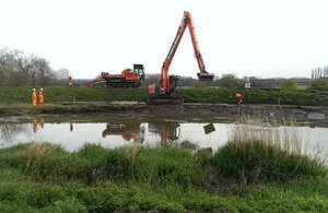
Dredging begins on the River Parrett in Somerset
Dredging of one of the major rivers in the Somerset Moors and Levels will begin today (31 March 2014), the Environment Agency announced.

Initial work on a 200-metre stretch of the River Parrett gets underway ahead of dredging of an eight kilometre stretch of river near where the Tone and Parrett meet at Burrowbridge.
Today’s preliminary work is on a key part of the river that has been specifically identified for dredging and where significant amounts of silt have built up. Dredging forms part of the ‘Somerset Levels and Moors Flood Action Plan’, commissioned by Environment Secretary Owen Paterson, and has been made possible by additional Government funding announced earlier this year.
The start of dredging follows on from months of extreme weather which saw the country’s largest-ever pumping operation on the Somerset Levels and Moors. Twenty-five temporary pumps, brought in by the Environment Agency to supplement the existing 40 pumps, worked to pump millions of tonnes of water off the Levels every day, meaning that residents were able to return to their homes as early as possible. Flood waters have now subsided meaning it is safe to start dredging.
Dredging is part of the joint action plan
Dr Paul Leinster, Chief Executive at the Environment Agency, said:
Today is an important milestone in the work to reduce the risk of flooding to people, property and land in Somerset and we welcome the additional money from Government that has allowed us to undertake this further dredging.
We are committed to dredging as part of the joint action plan which includes other measures such as supporting farmers and making some temporary flood risk management measures permanent. We will continue to work closely with Defra, Somerset County Council and other partners to reduce the impact of future floods.
John Osman, Leader of Somerset County Council Councillor, said:
We have contributed a significant amount of money to the pot for dredging and so we are extremely pleased to see the first dredging activity taking place.
It is vital that our flood-hit communities know this activity is taking place to give them some reassurance, but dredging is only part of the solution. The Somerset Moors and Levels Flood Action Plan is key to reducing the risk of flooding in the future and we will work hard to win the funding necessary to deliver it.
Some of the removed material will be used by the Environment Agency for flood bank repairs and construction to further improve flood resilience of the area.
The Environment Agency is working across the country to repair defences damaged over the last three months of extreme weather. During the winter 2013 / 2014 floods, many people suffered as around 6,500 properties were flooded. However, Environment Agency flood schemes defended more than 1.4 million homes and businesses and protected nearly 2,500 square kilometres of farmland across England.
Further information
- De-silting work was last carried out on targeted points on the Rivers Parrett and Tone in November 2013.
- The effectiveness of dredging in reducing flood risk varies river by river.
- On the Somerset Levels, flood risk management assets have protected more than 200 square kilometres of land and 3,500 properties - including in the towns of Langport, Martock, Ilchester and Ham.