England Coast Path: a step closer in Cumbria
Natural England has published its formal proposals to improve public access along a 55 km stretch of coast in Cumbria, between Whitehaven and Silecroft.

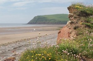
Coast at St Bees © Gerry Rusbridge / Natural England
From 15 October 2014, there is a period of 8 weeks for legal interests and members of the public to make objections or representations. The Secretary of State must take these into account when considering whether to approve the proposals.
If approved, this route will become part of the England Coast Path – the long distance walking route and National Trail - that is being developed around the entire English coast. Once completed, the path will be one of the longest coastal routes in the world.
Natural England has been working on the Cumbria section of the England Coast Path since 2011. The first new access rights were opened between Allonby and Whitehaven earlier this year.
This 55 km stretch extends south from Whitehaven and the proposed walking route will link together settlements such as St Bees, Seascale, Ravenglass and Silecroft. The route takes in mainly low-lying agricultural land and is in contrast to the dominating cliffs at St Bees Head.
The proposals at St Bees will also help to provide an improved and secure first stage of the classic Wainwright Coast to Coast route. Here, the cliffs rise high above sea level, to provide spectacular views of the Cumbrian mountains and coast.
Since 2012, Natural England and Cumbria County Council have met landowners and interested parties to ‘walk the course’, consider local issues and discuss the new route. The report outlines improvements to some of the existing access, as well as recommending many new sections between Whitehaven and Silecroft, with proposals to:
- identify a clear and continuous way-marked walking route along this part of the coast, bringing some sections of the existing coastal footpath closer to the sea and linking some places together for the first time
- allow the route to ‘roll back’ if the coastline erodes or slips, solving the long-standing difficulties of maintaining a continuous route along the coast
- secure legal rights of public access for the first time to the area’s beaches
Anyone can make representations to Natural England about the report during the 8 week consultation period. Owners and occupiers of affected land can make objections about the report on specified grounds, which will be considered by a Planning Inspector before the Secretary of State makes a final decision.
All representations and objections must be received by Natural England no later than 5pm on Wednesday 10 December 2014.
Copies of the report can be viewed in several locations along the coast between Whitehaven and Silecroft: the Copeland Centre, Whitehaven; Seacote Hotel, St Bees; Tarnside Caravan park, Braystones; Seascale Library; and The Pennington Hotel, Ravenglass .
The full report and all the forms and guidance on how to make a representation or objection within the next 8 weeks are also available on GOV.UK.
Natural England’s area manager Simon Humphries said; “This is the next step to establish the England Coast Path route along the Cumbria coastline, which will take in some fine views and many areas of coastline that have not previously had access.
“We’ve worked closely with Cumbria County Council, landowners and interested groups to identify a route and thank everyone for their time so far. We encourage anyone with a view on coastal access to take a look at the plans, which are now available for comment for the next eight weeks. Owners of land affected by the proposals may also submit a formal objection should they wish ”.
Councillor Keith Little, Cumbria County Council’s cabinet member for highways, said: “We are pleased to see the progress being made in developing this route further down the coast, following the successful completion of the section between Allonby and Whitehaven earlier this year. When linked together, these two stretches will give a fantastic walking experience, provide a real boost to the local economy and take us a step closer to a new national trail along our outstanding coastline.”
This report is issued under the revised coastal access scheme, which is the methodology for the whole project. This scheme was approved by the government in July 2013, and simplifies the process followed on each stretch of coast.
Notes to editors
Natural England press office contact: Emma Lusby, press officer / 0300 060 4231 / emma.lusby@naturalengland.org.uk
The Marine and Coastal Access Act 2009 places a duty on the Secretary of State and Natural England to secure a long distance walking trail around the open coast of England, together with public access rights to a wider area of land along the way for people to enjoy.
The England Coast Path will be a new long distance National Trail that will eventually allow people to walk 4,500km around the whole of the English Coast. In addition to Cumbria, Natural England is also currently working to deliver coastal access in several other locations around the country:
- south west: Somerset and Dorset
- south east: Kent
- east of England: Norfolk
- north east: Durham, Sunderland and Hartlepool, and North Yorkshire and East Riding of Yorkshire.
The right of access has already been introduced on stretches of the coast near Weymouth, and on other parts of the coast in Cumbria and Durham/Hartlepool and Sunderland.
For information about Natural England see GOV.UK or Twitter @NaturalEngland