Environment Agency exploring options to reduce Birmingham floods
The Bourn Flood Risk Management Scheme aims to minimise flooding from the River Bourn by creating flood storage areas to hold excess water during high rainfall.

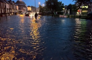
Flooding in the Stirchley area of Birmingham in 2016.
The Environment Agency is exploring options to help better protect communities in the Bournville and Stirchley areas of Birmingham from the devastation of flooding.
The Bourn Flood Risk Management Scheme aims to minimise flooding from the River Bourn, a tributary of the River Rea by creating flood storage areas to hold excess water from the watercourse during times of high rainfall.
Environment Agency modelling shows that approximately 200 residential properties and 100 businesses face the adverse impacts of flooding in the Bournville and Stirchley area.
The Bourn is prone to rapid flooding during intense storms as was seen in 2018 when 58mm fell in less than an hour over the Birmingham Conurbation resulting in significant river and surface water flooding. Flooding has also impacted communities in the area in 2008, 2012 and 2016.
Sites for the flood storage areas are being considered at Manor Farm Park, Weoley Hill Park and Valley Parkway in the Bournville area. Outside of these times the parks will still be usable as normal.
The flood storage areas will manage floodwaters during periods of heightened risk, such as large-scale events seen in 2018, to protect the local community and safeguard infrastructure. For the majority of the time the parks will continue to be used as they currently are by the surrounding communities.
Environment Manager for the Birmingham area Suzanne Ward said:
“We know the devastating impact that flooding can have, which is why protecting people and communities is our top priority.
“With anticipated climate change impacts and an increasing urban population, we are likely to see an increase in both the likelihood and impact of flood events in the future.
“It’s important to emphasis that no decisions have been made yet and we are still working on a concept design. We are committed to working with the community to seek their views and discuss any concerns they may have.”
Our aim will be to enhance the park landscapes and increase their biodiversity value whilst reducing flood risk to homes, communities and infrastructure including the local road and rail network.
The Environment Agency is committed to working with the community and hosted an open drop-in session at Weoley Village Hall in January. Further sessions, workshops, and information events will be taking place as the project progresses to maintain a transparent and inclusive approach.
More information can be found on the Bourn Flood Risk Management Scheme web page which is being regularly updated to reflect changes.