£200 million flood and coastal innovation programmes: mid-programme report
Published 28 October 2024
Applies to England

© Crown copyright 2024
This publication is licensed under the terms of the Open Government Licence v3.0 except where otherwise stated. To view this licence, visit nationalarchives.gov.uk/doc/open-government-licence/version/3 or write to the Information Policy Team, The National Archives, Kew, London TW9 4DU, or email: psi@nationalarchives.gov.uk.
Where we have identified any third party copyright information you will need to obtain permission from the copyright holders concerned.
This publication is available at https://www.gov.uk/government/publications/200-million-flood-and-coastal-innovation-programmes-mid-programme-report/200-million-flood-and-coastal-innovation-programmes-mid-programme-report
1. Foreword
The flood and coastal innovation programmes (the programmes) are developing new ways to manage flood and coastal erosion risks in the face of a changing climate. The programmes play a crucial role in helping to achieve the ambitions in the national Flood and Coastal Erosion Risk Management strategy. These are for a nation that is resilient to flooding and coastal change today, tomorrow and to the year 2100.
The learning from the programmes will also support government’s environmental commitments and its review of the Environment Improvement Plan.
The 35 local innovation projects are developing new methods and techniques, alongside practical actions to bolster flood and coastal resilience and climate adaptation. The main aims of the programmes are to:
- share and embed learning
- inform future policy and investment choices
This is why the Environment Agency has completed a mid-programme review. The review is informed by feedback from:
- project teams
- workshops
- interviews
- questionnaires
We shared initial high-level findings in the mid-programme summary in August 2024. This mid-programme report provides more details of the work of project teams across the country.
This includes:
- what has been achieved so far
- examples of the best innovations and learning
- the challenges encountered by project teams in delivering resilience and adaptation to flooding and coastal change
We would like to thank the dedicated project teams for their commitment and knowledgeable input, as well as Defra for their work championing the programmes.
Julie Foley
Director of Flood Risk Strategy and Adaptation, Environment Agency
2. Executive summary
In the 2020 Budget, government announced a £200 million innovation fund. This is led and managed by the Environment Agency.
The flood and coastal innovation programmes include the:
- flood and coastal resilience innovation programme – this is testing and implementing practical and innovative actions to improve resilience to flooding and coastal erosion
- coastal transition accelerator programme – this supports communities and businesses at risk of coastal erosion to transition and adapt to a changing coast
- adaptation pathways programme – this is developing adaptation pathway plans in locations of national significance, helping local places to better plan for and adapt to future flooding and coastal change
The programmes have already achieved many successes including:
- creating 97 natural flood management interventions – these use natural processes to help slow the flow and store floodwaters
- installing 572 river flow, rainfall and surface water monitoring sensors – these measure and monitor flood risk in real-time
- developing 3 artificial intelligence and machine learning projects using CCTV footage – these identify blockages on flood control structures
- creating 211 sustainable drainage system (SuDS) interventions – these help to control surface water runoff in urban areas reducing localised surface water flood risk
- securing about £21 million of partner funding contributions from water and sewerage companies, national public organisations, local authorities and the third sector
- enabling more than 20 local flood community groups – these help communities develop flood response plans so they can respond to and recover quickly from flooding
- supporting 25 PhD positions – these are investigating challenging areas of flood resilience and coastal transition
The learning from project teams has been drawn together into five themes:
- flood and coastal resilience can unlock significant wider social, economic and environmental benefits for people, places, and wildlife
- a lack of understanding and evidence hinders the coordination and delivery of groundwater flood risk management
- continual monitoring of flood and coastal resilience is vital to measuring performance and evaluating benefits over time
- flood and coastal resilience requires strong local leadership and governance, including community and political engagement
- the third sector are critical to delivery of flood and coastal resilience projects
This report highlights the:
- innovations and challenges in achieving flood and coastal resilience, adaptation and coastal transition
- learning we will share with government and partners around the country
3. Introduction
This report provides an update on the £200 million flood and coastal innovation programmes that are led and managed by the Environment Agency.
In the 2020 Budget the government announced a £200 million innovation fund. The fund helps meet the aims of the statutory national Flood and Coastal Erosion Risk Management strategy for England.
This report highlights the innovations and challenges in achieving flood and coastal resilience, adaptation and coastal transition at the mid-point of the programmes. We have developed it based on workshops, interviews, and reports from project teams.
4. The flood and coastal innovation programmes
The programmes have four core aims. These are to:
- test and demonstrate innovative practical resilience actions
- generate evidence on costs and benefits of resilience and adaptation
- enhance local resilience and adaptation to a changing climate
- use evidence to inform future policy and investment options
Between 2021 and 2027, the flood and coastal resilience innovation fund will share £200 million across three programmes. These are managed by the Environment Agency.
4.1 Flood and coastal resilience innovation programme (FCRIP)
This programme will receive £150 million. It covers 25 local authority projects. The projects will test and implement practical and innovative resilience actions to improve resilience to flooding and coastal erosion.
4.2 Coastal transition accelerator programme (CTAP)
This programme will receive £36 million. It is supporting communities and businesses at significant risk of coastal erosion to transition and adapt to a changing coast.
Projects have already started in:
- East Riding of Yorkshire
- North Norfolk
The programme has recently been expanded to include additional, smaller projects in:
- Bude in Cornwall
- Charmouth and Swanage in Dorset
4.3 Adaptation pathways programme (APP)
This programme will receive £8 million. It is developing adaptation pathway plans in locations of national significance. These will help local places to better plan for and adapt to future flooding, coastal change and climate hazards. Projects working on long term planning for climate adaptation are happening in:
- the Thames and Humber estuaries
- the Severn Valley
- Yorkshire
4.4 Other programme activities
The remaining funds are being used to:
- provide strategic support to the innovation programme projects (the projects)
- to evaluate the benefits of the programmes
We have also set up a knowledge exchange community for the programmes which provides full details of all projects.
We have also produced two online ‘Horizons’ magazines. You can read edition 1 and edition 2. The magazines share new evidence and best practice of on the ground delivery of the programmes.
As well as providing practical and innovative resilience actions, the innovation projects will help Defra with several policy challenge areas. These include:
- balancing agricultural, flood and environmental priorities in low-lying agricultural land
- meeting the need for major new developments in areas with flood risks
- retrofitting drainage and water management arrangements in urban areas
We are working closely with Defra to make sure the FCRIP projects help inform future policy development. The learning from the CTAP projects will also help to inform government policy options on spatial planning and land use for future coastal management.
5. Important metrics and achievements
As of October 2024, some of the important achievements of the programmes include:
- creating 97 natural flood management interventions that use natural processes to help slow the flow and store floodwaters – these include leaky barriers, small wetland ponds and enhancing marine habitats
- installing 572 river flow, rainfall and surface water monitoring sensors – these measure and monitor flood risk in real-time and allow us to maintain local flood control assets at the right time
- developing 3 artificial intelligence and machine learning projects using CCTV footage to identify blockages on flood control structures – these projects provide alerts to local authorities and smaller rural communities to improve readiness and response to flood incidents
- creating 211 SuDS interventions, including rainwater harvesting, water butts, permeable paving, storage and swales – these help to control surface water runoff in urban areas, reducing surface water flood risk to homes, schools and public spaces whilst enhancing public amenity
- securing around £21 million of partner funding contributions (from water and sewerage companies, national government organisations and local authorities) as well as contributions in kind (from trusts, charities and landowners) – this additional funding has enabled the projects to tackle wider societal issues such as anti-social behaviour, public health and improvements to public amenity
- enabling the formation of more than 20 local flood community groups and establishing 6 community resilience funds – these community groups have helped local people to come together to take action to develop community flood response plans and provide equipment to respond to and recover quickly from flooding
- supporting 25 PhD positions, which are investigating challenging areas of flood resilience and coastal transition – these include developing new methods for assessing the value for money of new and emerging flood and coastal resilience actions
You can also see these mid programme achievements summarised in infographic 1.
As of May 2024, the programmes’ forecast expenditure is on track. 99.8% of programmes spent to forecast between April 2023 and March 2024. All the projects have a high degree of delivery confidence.
The projects have also engaged extensively with stakeholders and partners across the flood and coastal innovation programmes. In total, 260 stakeholders have been involved across 35 projects. Table 1 shows the main groups involved.
Table 1: FCIP stakeholders
| Stakeholder | Number |
|---|---|
| FCRIP projects | 25 |
| Charity, trusts and communities | 104 |
| Local authorities | 78 |
| Consultancies and businesses | 32 |
| Academic | 21 |
| Water companies and internal drainage boards | 13 |
| Agencies and large non-governmental organisations | 12 |
You can also see this engagement summarised in infographic 2.
6. Mid programme review – important themes
We have combined the learning, successes and challenges from project teams into five themes. These are:
- flood and coastal resilience can unlock significant wider social, economic and environmental benefits for people, places, and wildlife
- a lack of understanding and evidence hinders the coordination and delivery of groundwater flood risk management
- continual monitoring of flood and coastal resilience is vital to measuring performance and evaluating benefits over time
- flood and coastal resilience requires strong local leadership and governance, including community and political engagement
- third sector organisations are often critical to the effective delivery of flood and coastal resilience projects
We will provide more information on each of these themes in the next section using examples from the project teams.
6.1 Theme 1: Flood and coastal resilience can unlock significant wider social, economic and environmental benefits for people, places, and wildlife
Overview
Flood and coastal resilience:
- provides wider benefits for people, local places and the natural environment
- creates opportunities to unlock other funding sources
Public realm benefits
Many projects have placed a strong emphasis on building social capital. They are empowering local communities and other local organisations to be involved in the co-design of flood and coastal resilience actions.
The Action for Silk Stream project is in Watling Park in the London Borough of Barnet. The project team has partnered with the police to align its sensitive landscape design with public realm improvements.
The aim is not only to reduce flood risk, but to also:
- create safer and more accessible public spaces
- reduce anti-social behaviour and crimes, especially those against women
This project has also secured £1.2 million partnership contributions from the Greater London Authority and Thames 21. These contributions support the enhancement of public open spaces through natural flood management and blue-green SuDS features.
The Resilient Roch project is located in Rochdale. It is combining property flood resilience and energy efficiency measures, to retrofit social housing targeted at disadvantaged communities in Littleborough and Wardleworth.
The local authority has aligned funding from a ~£3m package of energy efficiency measures with Ovo Energy to provide practical flood resilience and energy efficiency advice. This is helping to boost resilience and save money for householders.
The project team has also developed guidance on the co-delivery of flood resilience and energy surveys. This will help any other local authorities wishing to replicate the approach taken in Rochdale.
Local amenity benefits
Projects have sought to find ways to support communities by enhancing the resilience of important local community facilities to surface water flood risk.
The flood aware informed resilient (FAIR) project is in Staffordshire, Norton Canes. The public library has invested in an innovative ‘hydrorock’ (mineral wool) artificial aquifer which will help to capture and store surface water. This will prevent future flooding of this valuable community building.
Norton Canes library video, credit: FAIR project
The Reclaim the Rain project in Suffolk is partnering with J.S. Wright & Sons Cricket Bat Company to grow willow trees. The trees will:
- help to mitigate flood risk
- provide a long-term resource for cricket bat manufacture
Young willow trees have also been planted at Bower House Farm to help:
- mitigate surface water flood risk to the village of Boxford
- prevent soil erosion
- enhance water quality
Nature based solutions
The projects have also found ways of maximising the benefits of nature-based solutions to provide wider benefits to the local natural environment and supporting the local economy by using nature to safeguard tourism and enable new industries.
In South Tyneside, the Stronger Shores team are embracing nature-based solutions by establishing:
- seagrass meadows
- kelp forests
- oyster reefs
In certain conditions, kelp forests can lower wave energy by up to 50%, reducing the erosive power of wave action at the shore. They also have carbon sequestration benefits.
The team is partnering with academia to understand how such measures can reduce coastal erosion and deliver local economic benefits from an improved marine environment. Across the project sites, just under 20 million visitors use the beaches, coastal paths and parks each year contributing to the local visitor economy.
The project is also partnering with a commercial kelp farming company called Seagrown. This work will test opportunities for offshore kelp to benefit for the local economy.
Stronger Shores, South Tyneside (£6.7 million)
- where the project is – South Tyneside and surrounding coast (Tees to the Tweed) covering 6 locations
- risk sources – coastal erosion and coastal flooding
- resilience actions – nature-based solutions
- wider benefits – biodiversity, water quality, local economy, health and wellbeing
Work achieved so far:
- raised £235,000 of partner funding and contributions in kind
- established a sea grass meadow in North Gare, Teeside
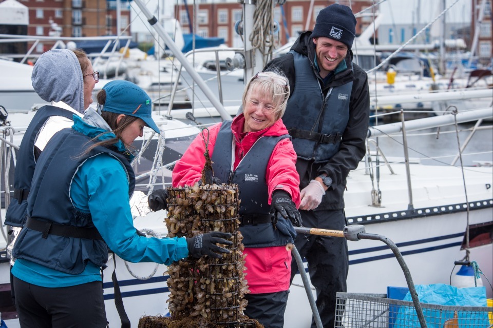
Photograph 1 - developing oyster reefs, credit Stronger Shores

Photograph 2 - seagrass propagation facility in Hartlepool, credit Stronger Shores
The Making Space for Sand project is in Cornwall. It is using nature-based solutions to:
- stabilise dune systems
- provide localised economic benefits for recreation
At one of their 40 sites on the Cornish coast, the project is supporting local community groups to ‘harvest’ marram grass from the Newquay Golf Club. They are replanting this in areas where sand is building up behind old Christmas trees and fencing.
These volunteer-led actions have helped to:
- strengthen the natural dunes
- kept access to the beach open to visitors
The estimated avoided flood and coastal risk damages of the project across the 40 sites, are estimated at between £30m and £60m over the next 100 years.
The main learning points under theme 1 are that:
- flood and coastal resilience actions can enable wider health, amenity and social benefits in local communities
- nature based solutions can benefit the local economy through community amenity improvements and supporting local tourism
6.2 Theme 2 - a lack of understanding and evidence hinders the coordination and delivery of groundwater flood risk management
Overview
Groundwater flooding:
- comes up through the ground or the floor and is often devastating for communities
- is far less understood compared to river or surface water flooding
- can persist for days, weeks or even months after heavy or prolonged rainfall
In England, the Flood and Water Management Act (2010) gives lead local flood authorities (LLFAs) a duty to manage groundwater flooding. However, because specialist knowledge is needed to manage groundwater, LLFAs often lack the necessary resources and evidence base to manage it effectively.
Collaboration on groundwater flood risk management
There are 3 groundwater projects within the programmes, covering 70% of England’s groundwater aquifer types. They cover 3 regions:
- Buckinghamshire
- Lincolnshire
- Northumbria
The 3 projects have partnered under the umbrella title of Project Groundwater, though they manage separate challenges.

Photograph 3 - Project Groundwater partners at the 2023 Project Groundwater summit, credit Project Groundwater
They have formed the Project Groundwater Network, which is sharing experiences of local authority staff, co-developing solutions and identifying strategic groundwater needs.
The network aims to:
- improve the evidence on groundwater flood risk
- provide options for better mitigating its impacts
- enable collaboration across organisations managing groundwater flood risk
Plugging evidence gaps
The Environment Agency’s review of groundwater flood risk management in England (2021) found that groundwater flooding is often completely overlooked in town and country planning. This is partly due to the lack of evidence on how to assess groundwater risks.
Project Groundwater: Buckinghamshire is aiming to fill this gap. The project is producing guidance for how developers and planners should assess groundwater flood risk in planning applications.
In Buckinghamshire alone, up to 200 communities and 70,000 properties are at risk of groundwater flooding. The project team have, for the first time, captured all the groundwater flood risk maps for the chalk aquifers across Buckinghamshire.
This library of evidence will be used:
- as part of Buckinghamshire’s next local flood risk management strategy
- to inform development planning decisions
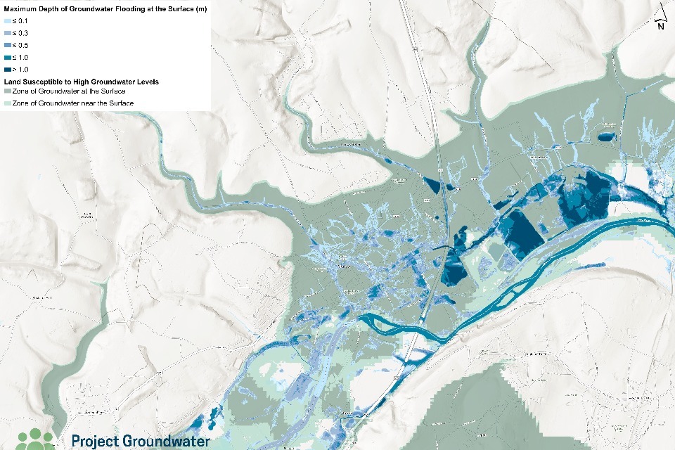
Photograph 4: Project Groundwater flood map for Marlow, Buckinghamshire showing groundwater flooding extents below and above ground, credit Project Groundwater
Project Groundwater: Lincolnshire is partnering with Middlesex University to update the ‘Multi-Coloured Manual’ for groundwater flooding. The manual:
- brings together information and research on the impacts of flooding and erosion
- allows projects to assess the economic benefits of different resilience actions
The team hope that better analysis of economic damages from groundwater flooding to property and agricultural land will simplify investment cases for groundwater flood risk projects.
Research into the long-term mental health impacts of groundwater flooding is less extensive compared to other types of flooding. The Project Groundwater Network is also partnering with academia to develop methods to better value the impacts of groundwater flooding on mental health.
Mitigating groundwater flood risk
Project Groundwater: Lincolnshire is transforming abandoned allotments in Grimsby into a £2 million wetland. This will help to mitigate groundwater flood risk for nearby homes. The Saltings Allotments have been largely unused since 2001 due to rising groundwater causing local flooding.
Outline designs for the wetland aim to increase the floodwater storage capacity across the site and provide new public amenity.
The main learning points under theme 2 are that:
- groundwater flood risk is not adequately considered when assessing applications for new development due to gaps in evidence and maps on groundwater flood risk
- there is a need for more research and evidence into the local economic benefits of groundwater flood management
6.3 Theme 3: Continual monitoring of flood and coastal resilience is vital to measuring performance and evaluating benefits over time
Overview
Monitoring is crucial to understand current and future flood and coastal risk. It helps us to measure and evaluate the impacts of investments in flood and coastal resilience.
Informing investment and maintenance
Better monitoring allows more targeted investment and maintenance decisions. This is crucial when managing constrained local authority budgets.
The Doncaster, Immingham & Grimsby project has pursued both monitoring and detailed drainage modelling to tackle surface water flooding.
The project partners include:
- local authorities
- water companies
- academia (SuDSLab)
The team have:
- established a network of 63 sensors
- completed a detailed drainage model of the urban catchments
- achieved a 90% saving on flow sensor costs – by swapping conventional impellor-based sensors with depth sensors
The monitoring data from the sensors is captured in real-time. The team are using it to identify parts of the network that could benefit from SuDS features. This includes:
- swales
- SuDS planters
- rain gardens
The team are making their monitoring data publicly available through the SuDSLab portal. The project team have already provided 60 SuDS interventions and identified opportunities for a further 134.
New approaches to flood warning and response
It is challenging to predict flooding from surface water and rivers in small catchments and urban areas. Flooding events:
- are often very localised
- develop quickly
- only last for short periods of time
The FCRIP projects in Devon and Northumberland have been exploring how to develop forecasting and warning services for isolated communities in small, rapid responding catchments. Doing this will give emergency responders and communities as much time to prepare as possible.
In East Sussex, the Blue Heart project has installed 66 real-time sensors to monitor water levels and rainfall. These will provide a better understanding of how water moves through Eastbourne and Wealden (a catchment of about 48 sq km).
Blue Heart project video, credit Blue Heart, East Sussex
Blue Heart’s real-time network will:
- allow river maintenance to be targeted which will help enhance the councils’ emergency response during flooding
- automatically release water and create more capacity for storing flood water in advance of predicted high rainfall
Using new technologies and artificial intelligence
Artificial intelligence (AI) and new remote sensing methods are being employed on a handful of projects. They will help us understand how flood risk management can be achieved more cost effectively and with greater accuracy.
Project Groundwater: Buckinghamshire has partnered with ISS Aerospace, to develop a ground penetrating radar (GPR) equipped drone.

Photograph 5 - ISS aerospace Ground Penetrating Radar (GPR) equipped drone, credit: Project Groundwater
The team are investigating how this technology can be used to monitor groundwater tables. They are using the drone in combination with borehole records to understand how GPR data can be verified and calibrated against local groundwater records. This technology could potentially reduce groundwater monitoring costs.
Some projects are also experimenting with AI. In Northumberland, the FloodAI project is developing a flood warning system across six isolated rural catchments, using AI and new sensor technology. The project team aim to develop a low cost, more accurate flood warning solution for isolated, rural communities, that are not covered by existing services. The team are applying AI to their network of 43 smart hydrometric sensors and river gauges to gather the information they need to develop automated flood warnings by 2025.
You can watch FloodAI project video on LinkedIn. Credit: FloodAI, Northumberland County Council.
The FAIR project is in Staffordshire. The team are working with the University of Reading to apply ‘machine learning’ to the processing of real-time CCTV footage of culverts. They are doing this both during and after heavy rainfall events. The technology aims to identify where maintenance or trash screen clearance is required to reduce the impacts of flooding and aid local incident response.
The main learning points under theme 3 are that:
- better monitoring can enable more targeted investment and maintenance decisions to help reduce the impacts of flooding
- use of artificial intelligence can play an important role in generating the real time information needed to support automated flood warnings
6.4 Theme 4: Flood and coastal resilience requires strong local leadership and governance, including community and political engagement
Overview
It is vital that community representatives and local elected members participate in flood and coastal resilience projects. This provides local democratic legitimacy. Many projects are being delivered through broad partnerships across multiple organisations.
These can include:
- local authorities
- academia
- NGOs
- consultancies
- charities
- community groups
Clear governance arrangements are crucial to make sure these partnerships work effectively.
Effective local leadership
Raising awareness of the risk of coastal change and erosion loss can be, for understandable reasons, an unpopular message to communicate.
The Coastwise project is in North Norfolk. The team are working with local elected leaders to help raise awareness of the implications of coastal erosion and coastal change amongst local residents.
This has been illustrated by the political leadership of Councillor Harry Blaythwayt. He has helped to:
- promote the importance of the council’s work rolling back property and infrastructure away from the eroding coastline in Trimingham
- raise awareness of the realities of coastal erosion through the national media
Councillor Blathwayt and Julie Foley of the Environment Agency were interviewed on coastal change and shoreline management planning for Planet Possible podcast.
You can listen to the How to Handle a Moving Coastline: Planet Possible podcast courtesy of Foley, J, Blaythwayt, H & Roach, N. (2024).
Partnership governance in flood and coastal resilience
Planning long term adaptation to flooding and coastal change requires strong partnerships between:
- communities
- local government
- risk management authorities (RMAs)
- local politicians
These partnerships can present unique governance challenges.
The Thames Estuary 2100 Plan team established a series of external steering groups. These stakeholders to collaborate and share their perspectives on the main challenges for the estuary.
These challenges include understanding how to:
- fund the implementation of the plan
- maintain and fund third party flood defences
- increase awareness of the plan amongst local authorities and the public
In addition to other government departments, these groups include representatives from:
- the Committee for Climate Change
- the Greater London Authority
- the Port of London Authority
- the Southern, Thames and Anglian Eastern Regional Flood and Coastal Committee
- the Infrastructure & Projects Authority and National Infrastructure Commission
This approach has led to greater alignment with the Thames Estuary Growth Board to support businesses within the estuary. A separate task force has been established chaired by the Thames Estuary Growth Board. The Board will support the delivery of the Thames Estuary 2100 Plan and its long-term ambition for a ‘climate resilient estuary’.
The Humber Strategy 2100+ team has applied the learning and governance structures from the Thames Estuary 2100 Plan to design their own partnership governance.
6.5 Community engagement and involvement in decision-making
CTAP project teams are applying a community-led approach to coastal transition. The Changing Coasts and Coastwise project teams are using open and honest dialogue with communities experiencing coastal erosion. They are using community engagement to reinforce the need for coastal transition plans to safeguard people, property and livelihoods for the long term.
Project teams have been able to benchmark:
- community awareness of coastal erosion
- their readiness to accept it
- their willingness to adapt
Coastwise project video, credit Coastwise, North Norfolk
Through the APP, project teams have also experimented with citizen’s panels to secure a diverse and inclusive range of community perspectives in local adaptation planning.
These panels have been developed in:
- the Thames estuary
- the Humber estuary
- Yorkshire
- the River Severn catchment
The panels captured live feedback from diverse communities and socioeconomic groups through facilitated workshops. These panels have:
- helped to strengthen community relations early-on in the decision-making process
- brought together a representative, consultative body of local residents from a range of background, to find out what matters to them and to test out different policy choices
- successfully gauged public understanding of current and future risks, and support for different policies, approaches or action
We are producing guidance for citizen’s panels, which will be available in 2024 to 2025.
The main learning points under theme 4 are that:
- coastal transition requires visible and proactive leadership by elected members to secure awareness and buy-in from communities, partners and local government
- citizen panels can ensure a diverse and inclusive range of community perspectives are heard and used to drive decisions in local adaptation planning
6.6 Theme 5: third sector organisations are often critical to the effective delivery of flood and coastal resilience projects
Overview
Third sector groups are often critical to building trust with local communities. This includes:
- local charities
- other local environmental organisations
These groups often unlock opportunities for collaboration with local landowners and farmers.
Building trust with communities
It is essential that those communicating information about flood and coastal resilience and adaptation are trusted by local communities and local partners. The third sector is well placed to lead on certain types of projects, for example natural flood management.
The Cumbria Innovative Flood Resilience project is funding Catchment Sensitive Farming Officers. These officers are building relationships with landowners and working with Cumbria Wildlife Trust to deliver natural flood management interventions.
The project has highlighted the value of forging strong community-based partnerships. The work has particularly benefited from the local experience and knowledge of landowners and farmers. Third sector partners can overcome initial reluctance from landowners by identifying funding options for the long-term maintenance of natural flood management measures. An example of this is through the Environmental Land Management (ELM) scheme.
The Community Bluescapes project is based in Richmond. The team are delivering nature-based solutions (for example, reed beds and SuDS) by partnering with the Wildfowl & Wetlands Trust and Friends of Barnes Common Ltd.
The partners are modifying their own landholdings to store and slow floodwater which helps reduce flood risk downstream. These landholdings include:
- parks
- wetlands
- grasslands
- recreational areas
Two new reedbeds are being established on Barnes Common. These will store water from the Beverley Brook and surface water runoff. The reedbeds provide:
- an important habitat for wildlife including Cetti’s warblers
- a refuge for fish and other creatures during flood events
The neighbouring Project Sponge project in Slough is a great example of a local authority working in partnership with third sector organisations to provide flood resilience. The project partnership includes the National Flood Forum (NFF) and the Wildfowl & Wetlands Trust.
The NFF are leading impartial community engagement in communities affected by flooding. The project team have found that:
- relaying flood risk information and messages through the NFF is more effective than through the local authority - it creates greater trust and more open dialogue in communities
- working with a third sector organisation has helped to break down communication barriers and enable better two-way communication and the co-development of SuDS solutions
The main learning points under theme 5 are that:
- the third sector is often better placed at building trust with local communities and working with landowners and farmers on flood resilience projects
- third sector organisations are often well placed to break down communication barriers with local communities at risk of flooding and erosion and enable better two way communication
7. Important challenges
An important part of innovation is learning by doing. This can sometimes mean failing well. Many projects are trialling methods for the very first time which means their success is not guaranteed.
We are capturing where:
- projects have trialled methods or techniques that have not worked as intended
- governance, policy or funding challenges may be impeding progress in delivering resilience and adaptation to flooding and coastal change
The Reclaim the Rain project in Suffolk has found it difficult to navigate the different policy, funding and regulatory frameworks for flood risk management and water resources management. As a result, the project has struggled to align its twin goals of enhancing both flood and drought resilience.
There are strict requirements for water abstraction licencing in areas that experience too much or too little water at different times of the year. This has made it challenging to develop options for dual-purpose flood and water storage. The team is working closely with the Environment Agency to overcome these challenges and to understand the policy hurdles.
The Action for Silk Stream project tested new thermosensors to detect where surface water is infiltrating the foul water network. Whilst initially promising, the technology:
- has proven unreliable and does not function as intended
- is not able to reliably identify the ingress of different water sources using temperature alone, offering poor correlation with water quality data
Many projects have struggled to manage and secure services from local community groups or smaller third sector organisations.
There can be a lack of:
- experience and knowledge in project development and procurement skills – this can hold up work
- familiarity with the government’s Functional Standards and the due diligence checks that ensure consistency, regularity and propriety in administering government grants
Larger third sector organisations and charities often have a much greater experience and skills to lead and manage multi-disciplinary project delivery.
8. Putting learning into practice
The programmes have gathered a wealth of evidence so far. This shows how flood and coastal resilience, adaptation and coastal transition can be achieved successfully.
An important aspect of the programmes is to make sure that useful learning, techniques and evidence is quickly mainstreamed into flood and coastal risk management activities.
We will make a knowledge management system available to RMAs to help them achieve local resilience and adaptation.
The knowledge management system will hold:
- case studies
- tools
- data
- technical guidance
- videos
- briefings
- a range of other materials
We are also working with project teams to find ways to share learning so that it can inform future investment choices.
An example of this is from the York Ousewem project. The team developed a local tool to appraise the flood risk and economic benefits of natural flood management interventions. We have used this work to help develop a new national tool for consistently estimating flood risk reductions and other environmental benefits. This will help to save time and avoid disproportionate project development costs.
The new national tool has been used as part of the project selection process for the Natural Flood Management programme. It will also be used to help inform policy options for mainstreaming natural flood management in our future investment programmes
We have partnered with the Association of Directors for Environment, Economy, Planning & Transport to share learning from the APP with local authorities.
The lessons learnt from the APP have been used to create an adaptation pathways explainer video for local authorities. This introduces the theory and application of the pathways approach.
More recently, we have partnered with ADEPT to co-develop a Rapid Adaptation Pathways (RAPA) toolkit for local authorities.
ADEPT-EA Adaptation Pathways explainer video
The Cumbria innovative flood resilience (CiFR) project has also produced four ‘stop-motion’ animations. These aim to communicate clear and important information about flooding to communities and young people.
The wild ideas about flooding videos secured first prize in the Educational Film category of the Learning on Screen awards at the British Film Institute. The project team has now produced four new videos, which you can see on our YouTube channel.
The innovation programmes have secured two honours at the 2024 Flood & Coastal Excellence Awards. These were for:
- the Resilience and Innovation Northants (RAIN) project, which won the ‘Innovation and Resilience’ award – this recognised their use of innovative resilience solutions to flooding and coastal change
- Anna Hastings, of the Blue Heart project, also won the ‘Early Career Professional’ award
9. Next steps
This mid-programme review has provided an overview of delivery, successes and challenges from the 35 projects so far. We have outlined how learning is being shared so communities can benefit from improved resilience and adaptation to flooding and coastal change.
We will continue to:
- gather evidence from the programmes between now and 2027, which will support continuous improvement and development in FCERM
- work closely with Defra to inform work on future policy reform on coastal transition, strategic flood risk planning and water level management
For more information, see the flood and coastal innovation programmes website, or email the Environment Agency at innovativeresilience@environment-agency.gov.uk.