Avon Bristol and Somerset North Streams management catchment: baseline length of rivers and estuaries polluted by abandoned metal mines
Published 12 March 2025
Applies to England

© Crown copyright 2025
This publication is licensed under the terms of the Open Government Licence v3.0 except where otherwise stated. To view this licence, visit nationalarchives.gov.uk/doc/open-government-licence/version/3 or write to the Information Policy Team, The National Archives, Kew, London TW9 4DU, or email: psi@nationalarchives.gov.uk.
Where we have identified any third party copyright information you will need to obtain permission from the copyright holders concerned.
This publication is available at https://www.gov.uk/government/publications/abandoned-metal-mines-in-england-baseline-length-of-rivers-and-estuaries-polluted-by-harmful-metals/avon-bristol-and-somerset-north-streams-management-catchment-baseline-length-of-rivers-and-estuaries-polluted-by-abandoned-metal-mines
This is one of 20 reports, one for each polluted management catchment, on the water quality monitoring undertaken by the Environment Agency to determine the baseline length of rivers and estuaries considered polluted by any of the Environment Act target substances from abandoned metal mines in 2022.
A length of river or estuary is considered polluted where the concentration of one or more of the 6 target substances (arsenic, cadmium, copper, lead, nickel and zinc) exceeds the relevant Environmental Quality Standard (EQS). EQS concentrations are based on ecotoxicology data and set by Government at a level that should prevent harmful environmental impacts. When the concentration of a substance in a water sample is higher than the EQS, adverse impacts on the aquatic ecosystem can be expected. The relevant EQS for each target substance are set out in The Water Framework Directive (Standards and Classification) Directions (England and Wales) 2015.
The purpose of calculating this baseline was to enable measurement of the statutory abandoned metal mines target set out in Part 4 of the Environmental Targets (Water) (England) Regulations 2023. This regulation requires that the combined length of English rivers and estuaries polluted by the target substances from abandoned metal mines is, by 31 December 2038, at least 50% lower than the baseline.
In the Avon Bristol and Somerset North Streams management catchment, the baseline length of polluted rivers for the abandoned metal mines water target is 25km. We will aim to identify the key sources of metal pollution in this management catchment by carrying out detailed monitoring investigations.
You can find further background and context on the Environment Act abandoned metal mines water target in the national baseline report which should be read together with this report.
The Avon Bristol and Somerset North Streams management catchment
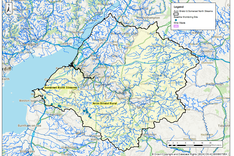
The Avon Bristol and Somerset North Streams management catchment covers an area of approximately 2,808km2 and includes areas of the Cotswolds National Landscape, the North Wessex Downs National Landscape and the Mendip Hills National Landscape. Please go to Avon Bristol and Somerset North Streams Management Catchment on the Catchment Data Explorer for an interactive map showing the 4 operational catchments that make up the management catchment. The boundary of the Avon Bristol and Somerset North Streams management catchment and all 4 operational catchments are highlighted in Figure 1.
Metal mining in the Avon Bristol and Somerset North Streams management catchment
There is a long history of metal mining in the Mendips Hills. The Harptree area was an important lead and zinc mining area. Lead ore was mined from veins in the Carboniferous Limestone around Gibbets Brow and Lamb Leer, and manganese and zinc from veins in the Dolomitic Conglomerate around Harptree Combe. This has left a legacy of old pits, spoil heaps and shafts creating areas of pockmarked ‘gruffy ground’. Much of the ore was processed and smelted on Smitham Hill where ore dressing and smelting works were built by the East Harptree Lead Works Company in 1867. The Smitham Chimney dates from this time and is the last old lead-smelting chimney still standing on Mendip. To the south-west of Harptree, lead was also mined from the Chewton area. For more information, please visit Mendip Mines - Northern Mine Research Society (nmrs.org.uk).
Figure 1 shows the areas of abandoned mine wastes (mining spoil) in the Avon Bristol and Somerset North Streams management catchment. There are currently no mapped mine water discharges in this catchment.
Figure 1. Map showing the abandoned metal mines, mineral veins and baseline river monitoring sites in the Avon Bristol and Somerset North Streams management catchment
© Environment Agency
This information has been gathered from various sources including:
- BGS Geological mapping - GeoIndex - British Geological Survey
- Prioritisation of abandoned non-coal mine impacts on the environment
- Inventory of closed mining waste facilities causing serious environmental impacts
- Defra-funded ‘Source apportionment of pollution from non-coal mines’ research project by Newcastle University and Hull University (unpublished)
- Environment Agency water quality data archive
Most of the historical mining activities in the Avon Bristol and Somerset North Streams management catchment were concentrated in the Somerset North Streams and Avon Bristol Rural operational catchments.
The tables below list the catchments (surface water bodies) that are polluted by target substances from abandoned metal mines in the Avon Bristol and Somerset North Streams management catchment. These tables highlight where there are known point sources (mine adits or mine drainage levels) and diffuse sources (mine wastes or spoil heaps) within the catchment. The Environment Agency is continuing to investigate point and diffuse sources within the Avon Bristol and Somerset North Streams management catchment by undertaking a series of catchment characterisation studies. These studies will help us identify which sources of metals need to be tackled to achieve the long-term statutory target.
Avon Bristol Rural operational catchment: sources of metal pollution
Table 1 summarises which type of pollution sources from abandoned metal mines have been identified within the catchments (surface water bodies) in the Avon Bristol Rural operational catchment.
Table 1. Summary of metal pollution sources in the Avon Bristol Rural operational catchment
| Catchment (Surface water body) | Point sources of pollution | Diffuse sources of pollution |
|---|---|---|
| Chew: source to Chew Valley Lake | Further investigation required | Yes |
| Chew - Chew Valley Lake to conf Winford Brook | Further investigation required | Further investigation required |
| Winford Bk - source to conf R Chew | Further investigation required | Further investigation required |
Somerset North Streams operational catchment: sources of metal pollution
Table 2 summarises which type of pollution sources from abandoned metal mines have been identified within the catchments (surface water bodies) in the Somerset North Streams operational catchment.
Table 2. Summary of metal pollution sources in the Somerset North Streams operational catchment
| Catchment (Surface water body) | Point sources of pollution | Diffuse sources of pollution |
|---|---|---|
| Oldbridge River - source to nr Manor Fm | Further investigation required | Yes |
Baseline monitoring
The objective of the baseline monitoring was to establish the upstream and downstream extent of surface waters polluted by the target substances from abandoned metal mines. We selected the baseline monitoring sites by first completing a desk study to review previous water quality data, maps and reports. We then made initial site visits to collect samples and to assess the suitability of the site for continued sampling. Generally, at least twelve water quality samples were then collected from each monitoring site.
Within the Avon Bristol Somerset North Streams management catchment, water quality monitoring was undertaken in 2 out of the 4 operational catchments (Avon Bristol Rural and Somerset North Streams). We did not carry out monitoring in operational catchments where there is either no historical metal mining within the catchment or a combination of current and historical monitoring data shows that waterbodies within these catchments are not polluted by abandoned metal mines.
In total, 13 monitoring sites were selected across the Avon Bristol and Somerset North Streams management catchment to determine the baseline length of rivers polluted by target substances from abandoned metal mines. The locations of these monitoring sites are shown in Figure 1.
Water quality data collected between 1 January 2022 and 31 March 2024 have been used to determine and validate the baseline length of rivers and estuaries considered polluted in 2022. The length of rivers polluted by abandoned metal mines fluctuates in response to natural variation in rainfall and river flows. However, this length will not materially change unless remediation measures like mine water treatment schemes or diffuse interventions are installed to decrease inputs of metals. Therefore, data collected after 31 December 2022 are considered to be representative of rivers, provided no new remediation measures had been constructed since 2022. No new remediation measures have been constructed in the Avon Bristol Somerset North Streams management catchment since 2022.
Water quality monitoring results
In the Avon Bristol and Somerset North Streams management catchment, the target substances measured were cadmium, copper, lead, nickel and zinc. We did not undertake testing for arsenic in this management catchment since historical monitoring data and knowledge of the local geology across the catchment indicated that no rivers are polluted by arsenic in this management catchment.
The baseline water quality data for all monitoring sites are available on the Environment Agency’s public water quality archive.
For a river water quality sample to be considered polluted, concentrations of one or more of the target substances must exceed the relevant Environmental Quality Standards (EQS) set by Government when assessed as an “annual average”. The EQS are set out in The Water Framework Directive (Standards and Classification) Directions (England and Wales) 2015.
The EQS are derived using ecotoxicology data and set at a level that should prevent harmful environmental impacts. When the concentration of a substance in a water sample is higher than the EQS, adverse impacts on the aquatic ecosystem can occur, and the sample is considered to be polluted.
To understand the severity of pollution, we calculated a numeric “pollution level” by dividing the measured concentration of the target substances by the EQS. If the pollution level is greater than 1, the monitoring site is considered polluted by that target substance. Therefore, the higher the numeric pollution level, the greater the likelihood of harm to aquatic life.
Baseline polluted river length: Avon Bristol and Somerset North Streams management catchment
Our detailed monitoring across a range of flow conditions between January 2022 and March 2024 shows that in the Avon Bristol and Somerset North Streams management catchment, the baseline length of polluted rivers for the abandoned metal mines target is 25km.
Figure 2 shows the rivers in the Avon Bristol and Somerset North Streams management catchment that are polluted by target substances from abandoned metal mines.
Figure 2. The baseline length of rivers polluted by target substances from abandoned metal mines in the Avon Bristol and Somerset North Streams management catchment is 25km
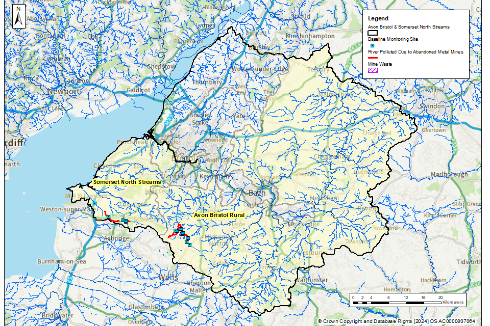
© Environment Agency
Table 3 shows the river length (in km) that are polluted by each of the target substances within the Avon Bristol and Somerset North Streams management catchment.
In general, the most polluted rivers are impacted by more than one target substance.
Table 3. River length (in km) polluted by each of the target substances within the Avon Bristol and Somerset North Streams management catchment.
| Target substance | Polluted river length (km) | Pollution level: less than 3 times | Pollution level: 3 to 5 times | Pollution level: greater than 5 times |
|---|---|---|---|---|
| Cadmium (Cd) | 23 | 16 | 0 | 7 |
| Lead (Pb) | 7 | 2 | 0 | 5 |
| Nickel (Ni) | 0 | 0 | 0 | 0 |
| Zinc (Zn) | 25 | 1 | 17 | 17 |
| Copper (Cu) | 0 | 0 | 0 | 0 |
Rivers polluted by abandoned metal mines: Avon Bristol and Somerset North Streams management catchment
Avon Bristol Rural operational catchment: baseline polluted rivers
All monitored baseline sites in the Chew catchment upstream of Chew Valley Lake are polluted by zinc and cadmium. Pollution levels are particularly high in the Molly Brook tributary which is polluted for zinc, cadmium and lead. This stream drains East Harptree Woods, a site of extensive historic lead and zinc mining.
Figure 3 shows the baseline polluted rivers in this operational catchment.
Figure 3. The baseline length of rivers polluted by target substances from abandoned metal mines in the Avon Bristol Rural operational catchment is 18km
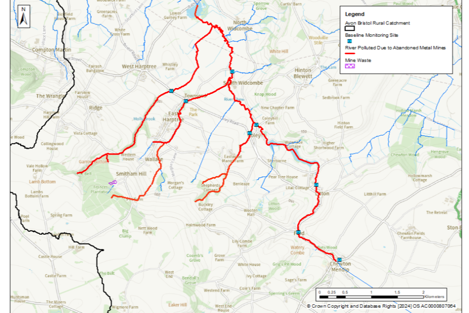
© Environment Agency
It should be noted that due to close proximity of some of the sampling points to each other, some of the sampling point markers on this map (blue squares) may overlap.
Somerset North Streams operational catchment: baseline polluted rivers
Monitoring data shows that both the Churchill Rhyne and the Towerhead brook are polluted by one or more target substances at a certain point on the watercourse. Both watercourses are tributaries of the Oldbridge River. It was difficult to determine the downstream extent of the pollution on these tributaries or on the Oldbridge River due to a lack of suitably accessible monitoring points. Limited monitoring of 2 tributaries upstream of the monitoring point on the Churchill Rhyne (Rowberrow Warren 1 and Rowberrow Warren 2) indicated that zinc, lead and cadmium were elevated in Rowberrow Warren 2 which drains the south of Rowberrow Warren.
Figure 4 shows the baseline polluted rivers in this operational catchment.
Figure 4. The baseline length of rivers polluted by target substances from abandoned metal mines in the Somerset North Streams operational catchment is 7km
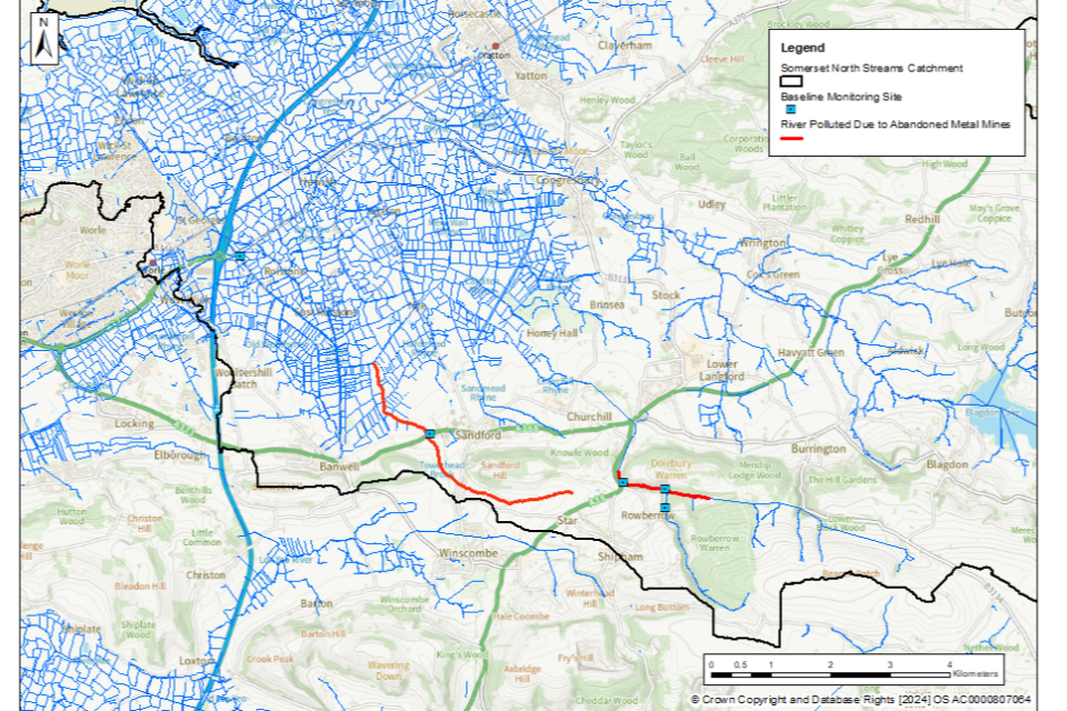
© Environment Agency
It should be noted that due to close proximity of some of the sampling points to each other, some of the sampling point markers on this map (blue squares) may overlap.