Somerset South and West management catchment: baseline length of rivers and estuaries polluted by abandoned metal mines
Published 12 March 2025
Applies to England

© Crown copyright 2025
This publication is licensed under the terms of the Open Government Licence v3.0 except where otherwise stated. To view this licence, visit nationalarchives.gov.uk/doc/open-government-licence/version/3 or write to the Information Policy Team, The National Archives, Kew, London TW9 4DU, or email: psi@nationalarchives.gov.uk.
Where we have identified any third party copyright information you will need to obtain permission from the copyright holders concerned.
This publication is available at https://www.gov.uk/government/publications/abandoned-metal-mines-in-england-baseline-length-of-rivers-and-estuaries-polluted-by-harmful-metals/somerset-south-and-west-management-catchment-baseline-length-of-rivers-and-estuaries-polluted-by-abandoned-metal-mines
This is one of 20 reports, one for each polluted management catchment, on the water quality monitoring undertaken by the Environment Agency to calculate the baseline length of rivers and estuaries considered polluted by any of the Environment Act target substances from abandoned metal mines in 2022.
A length of river or estuary is considered polluted where the concentration of one or more of the 6 target substances (arsenic, cadmium, copper, lead, nickel and zinc) exceeds the relevant Environmental Quality Standard (EQS). EQS concentrations are based on ecotoxicology data and set by Government at a level that should prevent harmful environmental impacts. When the concentration of a substance in a water sample is higher than the EQS, adverse impacts on the aquatic ecosystem can be expected. The relevant EQS for each target substance are set out in The Water Framework Directive (Standards and Classification) Directions (England and Wales) 2015.
The purpose of calculating this baseline was to enable measurement of the statutory abandoned metal mines target set out in Part 4 of the Environmental Targets (Water) (England) Regulations 2023. This regulation requires that the combined length of English rivers and estuaries polluted by the target substances from abandoned metal mines is, by 31 December 2038, at least 50% lower than the baseline.
In the Somerset South and West management catchment, the baseline length of polluted rivers for the abandoned metal mines water target is 45km. We will aim to identify the key sources of metal pollution in this management catchment by carrying out detailed monitoring investigations.
You can find further background and context on the Environment Act abandoned metal mines water target in the national baseline report which should be read together with this report.
The Somerset South and West management catchment
The Somerset South and West management catchment covers an area of approximately 2,816km2 and encompasses areas of Exmoor National Park, along with the Quantock Hills National Landscape and the Mendip Hills National Landscape. Please go to Somerset South and West Management Catchment on the Catchment Data Explorer for an interactive map showing the 4 operational catchments that make up the management catchment. The boundary of the Somerset South and West management catchment and all 4 operational catchments are highlighted in Figure 1.
Metal mining in the Somerset South and West management catchment
Metal mining in the catchment was largely centred in the area around the Mendip Hills. The central Mendips, which include the famous mineries at Charterhouse and Priddy, have been mined for lead from at least Roman times right up to the start of the 20th century. To the west, the village of Shipham became a major mining centre following the discovery of zinc ore in the 16th century, and elevated concentrations of cadmium have been reported in local soils. Further information can be found at Mendip Mines - Northern Mine Research Society.
Within Exmoor National Park, iron ore was mined from the Brendon Hills in the latter half of the 19th century. A large area of the Brendon Hills was leased to the Brendon Hills Iron Ore Company from which iron ore was exported to South Wales.
Figure 1 shows the locations of mineral veins, known mine water discharges, closed mine waste facilities known to be causing serious environmental harm, and areas of abandoned mine wastes (mining spoil) in the Somerset South and West management catchment.
This information has been gathered from various sources including:
- BGS Geological mapping - GeoIndex - British Geological Survey
- Prioritisation of abandoned non-coal mine impacts on the environment
- Inventory of closed mining waste facilities causing serious environmental impacts
- Defra-funded ‘Source apportionment of pollution from non-coal mines’ research project by Newcastle University and Hull University (unpublished)
- Environment Agency water quality data archive
As we can see in Figure 1, most of the historical mining activities in the Somerset South and West were concentrated in the Brue and Axe and West Somerset Streams operational catchments.
Figure 1. Map showing the abandoned metal mines, mineral veins and baseline river monitoring sites in the Somerset South and West management catchment
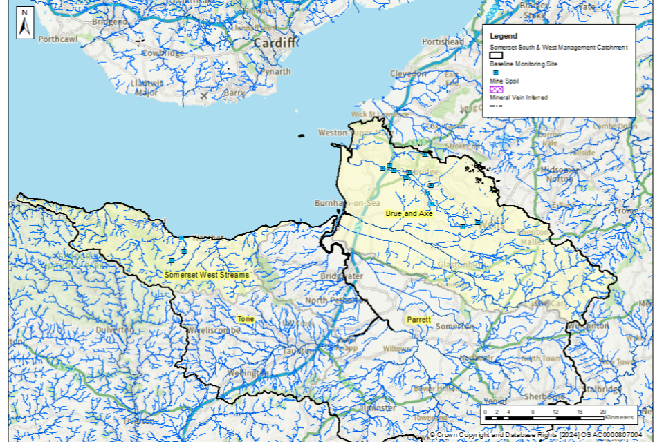
© Environment Agency
The tables below list the catchments (surface water bodies) that are polluted by target substances from abandoned metal mines in the Somerset South and West management catchment. These tables highlight where there are known point sources (mine adits or mine drainage levels) and diffuse sources (mine wastes or spoil heaps) within the catchment. The Environment Agency is continuing to investigate point and diffuse sources within the Somerset South and West management catchment by undertaking a series of catchment characterisation studies. These studies will help us identify which sources of metals need to be tackled to achieve the long-term statutory target.
Brue and Axe operational catchment: sources of metal pollution
Table 1 summarises which type of pollution sources from abandoned metal mines have been identified within the catchments (surface water bodies) in the Brue and Axe operational catchment.
Table 1. Summary of metal pollution sources in the Brue and Axe operational catchment
| Catchment (Surface water body) | Point sources of pollution | Diffuse sources of pollution |
|---|---|---|
| Cheddar Yeo - source to conf Stubbingham Rhyne | Further investigation required | Further investigation required |
| Axe - source to Cocklake | Further investigation required | Further investigation required |
| Axe - Cocklake to Brean Cross Sluice | Further investigation required | Further investigation required |
| Lox Yeo – source to conf River Axe | Further investigation required | Further investigation required |
Somerset West Streams operational catchment: sources of metal pollution
Table 2 summarises which type of pollution sources from abandoned metal mines have been identified within the catchments (surface water bodies) in the Somerset West Streams operational catchment.
Table 2. Summary of metal pollution sources in the Somerset West Streams operational catchment
| Catchment (Surface water body) | Point sources of pollution | Diffuse sources of pollution |
|---|---|---|
| Pill | Further investigation required | Further investigation required |
Baseline monitoring
The objective of the baseline monitoring was to establish the upstream and downstream extent of surface waters polluted by the target substances from abandoned metal mines. We selected the baseline monitoring sites by first completing a desk study to review previous water quality data, maps and reports. We then made initial site visits to collect samples and to assess the suitability of the site for continued sampling. Generally, at least twelve water quality samples were then collected from each monitoring site.
Within the Somerset South and West management catchment, water quality monitoring was undertaken in 2 out of the 4 operational catchments (Brue and Axe and Somerset West Streams). We did not carry out monitoring in operational catchments where there is either no historical metal mining within the catchment or a combination of current and historical monitoring data shows that waterbodies within these catchments are not polluted by abandoned metal mines.
In total, 14 monitoring sites were selected across the Somerset South and West management catchment to determine the baseline length of rivers polluted by target substances from abandoned metal mines. The locations of these monitoring sites are shown in Figure 1.
Water quality data collected between 1 January 2022 and 31 March 2024 have been used to determine and validate the baseline length of rivers and estuaries considered polluted in 2022. The length of rivers polluted by abandoned metal mines fluctuates in response to natural variation in rainfall and river flows. However, this length will not materially change unless remediation measures like mine water treatment schemes or diffuse interventions are installed to decrease inputs of metals. Therefore, data collected after 31 December 2022 are considered to be representative of rivers, provided no new remediation measures had been constructed since 2022. No new remediation measures have been constructed in the Somerset South and West management catchment since 2022.
Water quality monitoring results
In the Somerset South and West management catchment, the target substances measured were cadmium, copper, lead, nickel and zinc. We did not undertake testing for arsenic in this management catchment since historical monitoring data and knowledge of the local geology across the catchment indicated that no rivers are polluted by arsenic in this management catchment.
The baseline water quality data for all monitoring sites are available on the Environment Agency’s public water quality archive.
For a river water quality sample to be considered polluted, concentrations of one or more of the target substances must exceed the relevant EQS set by Government when assessed as an “annual average”. The EQS are set out in The Water Framework Directive (Standards and Classification) Directions (England and Wales) 2015.
The EQS are derived using ecotoxicology data and set at a level that should prevent harmful environmental impacts. When the concentration of a substance in a water sample is higher than the EQS, adverse impacts on the aquatic ecosystem can occur, and the sample is considered to be polluted.
To understand the severity of pollution, we calculated a numeric “pollution level” by dividing the measured concentration of the target substances by the EQS. If the pollution level is greater than 1, the monitoring site is considered polluted by that target substance. Therefore, the higher the numeric pollution level, the greater the likelihood of harm to aquatic life.
Baseline polluted river length: Somerset South and West management catchment
Our detailed monitoring across a range of flow conditions between January 2022 and March 2024 shows that in the Somerset South and West management catchment, the baseline length of polluted rivers for the abandoned metal mines target is 45km.
Figure 2 shows the rivers in the Somerset South and West management catchment that are polluted by target substances from abandoned metal mines.
Figure 2. The baseline length of rivers polluted by target substances from abandoned metal mines in the Somerset South and West management catchment is 45km
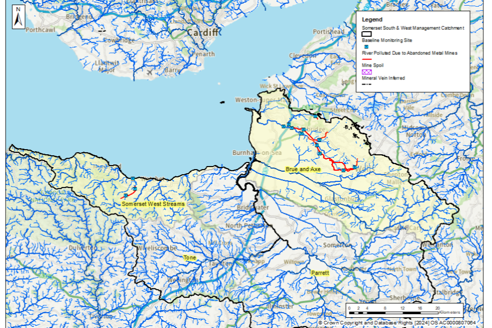
© Environment Agency
Table 3 shows the river length (in km) that are polluted by each of the target substances within the Somerset South and West management catchment. In general, the most polluted rivers are impacted by more than one target substance.
Table 3. River length (in km) polluted by each of the target substances within the Somerset South and West management catchment
| Target substance | Polluted river length (km) | Pollution level: less than 3 times | Pollution level: 3 to 5 times | Pollution level: more than 5 times |
|---|---|---|---|---|
| Cadmium (Cd) | 12 | 10 | 2 | 0 |
| Lead (Pb) | 38 | 24 | 4 | 10 |
| Nickel (Ni) | 0 | 0 | 0 | 0 |
| Zinc (Zn) | 45 | 25 | 7 | 13 |
| Copper (Cu) | 0 | 0 | 0 | 0 |
Rivers polluted by abandoned metal mines: Somerset South and West management catchment
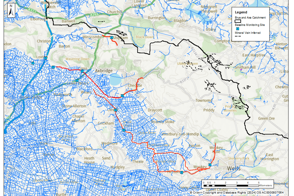
Brue and Axe operational catchment: baseline polluted rivers
The River Axe is polluted for one or more target substances at the farthest upstream monitoring location at Henley Hill by cadmium, zinc and lead. Historically, water quality monitoring confirms that the River Axe is polluted upstream of this point to its source at the mouth of the Wookey Hole cave system (approximately 2km upstream). Downstream of Henley Hill, the River Axe is polluted to the monitoring point at Clewer.
Cheddar Yeo is also polluted at the most upstream monitoring location at Hythe down to the confluence with the River Axe by cadmium, zinc and lead. Upstream of Hythe, historical monitoring data shows that Cheddar Yeo fails up to its source at Goughs Old Cave (approximately 2km upstream). Both the River Axe and Cheddar Yeo converge approximately 0.5km upstream of the baseline monitoring site at Crab Hole, where the watercourse is no longer polluted by any of the target substances
A small un-named stream at Winterhead, downstream of the village of Shipham, is polluted by zinc and cadmium from its source (a spring) to the point at which it sinks underground just past the A38 road bridge at Winscombe.
Figure 3 shows the baseline polluted rivers in this operational catchment.
Figure 3. The baseline length of rivers polluted by target substances from abandoned metal mines in the Brue and Axe operational catchment is 40km
© Environment Agency
It should be noted that due to close proximity of some of the sampling points to each other, some of the sampling point markers on this map (blue squares) may overlap.
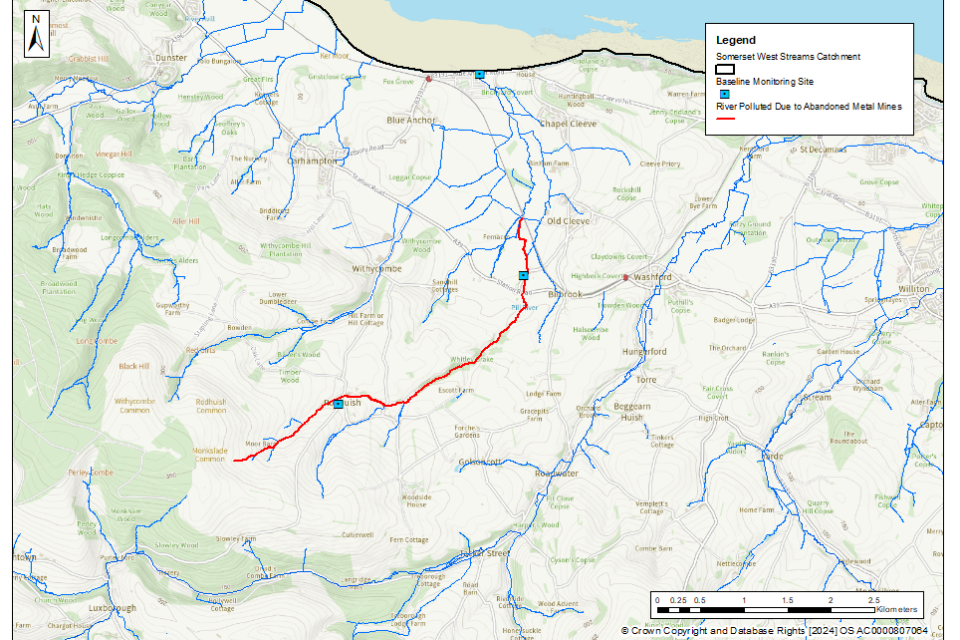
Somerset West Streams: baseline polluted rivers
The Pill River is polluted by zinc and cadmium at the most upstream monitoring point at Rodhuish Farm from its source on the northeastern slopes of Monkham Hill. Some dilution has occurred by the time the Pill River reaches the next downstream monitoring location at Bilbrook Ford although the river remains polluted by zinc. Monitoring shows that the river is no longer polluted by any of the target substances where the Pill River flows into Bridgewater Bay at Blue Anchor.
Figure 4 shows the baseline polluted rivers in this operational catchment.
Figure 4. The baseline length of rivers polluted by target substances from abandoned metal mines in the Somerset West Streams operational catchment is 5km
© Environment Agency