Swale, Ure, Nidd, Ouse Upper management catchment: baseline length of rivers and estuaries polluted by abandoned metal mines
Published 12 March 2025
Applies to England

© Crown copyright 2025
This publication is licensed under the terms of the Open Government Licence v3.0 except where otherwise stated. To view this licence, visit nationalarchives.gov.uk/doc/open-government-licence/version/3 or write to the Information Policy Team, The National Archives, Kew, London TW9 4DU, or email: psi@nationalarchives.gov.uk.
Where we have identified any third party copyright information you will need to obtain permission from the copyright holders concerned.
This publication is available at https://www.gov.uk/government/publications/abandoned-metal-mines-in-england-baseline-length-of-rivers-and-estuaries-polluted-by-harmful-metals/swale-ure-nidd-ouse-upper-management-catchment-baseline-length-of-rivers-and-estuaries-polluted-by-abandoned-metal-mines
This is one of 20 reports, one for each polluted management catchment, on the water quality monitoring undertaken by the Environment Agency to calculate the baseline length of rivers and estuaries considered polluted by any of the Environment Act target substances from abandoned metal mines in 2022.
A length of river or estuary is considered polluted where the concentration of one or more of the 6 target substances (arsenic, cadmium, copper, lead, nickel and zinc) exceeds the relevant Environmental Quality Standard (EQS). EQS concentrations are based on ecotoxicology data and set by government at a level that should prevent harmful environmental impacts. When the concentration of a substance in a water sample is higher than the EQS, adverse impacts on the aquatic ecosystem can be expected. The relevant EQS for each target substance are set out in The Water Framework Directive (Standards and Classification) Directions (England and Wales) 2015.
The purpose of calculating this baseline was to enable measurement of the statutory abandoned metal mines target set out in Part 4 of the Environmental Targets (Water) (England) Regulations 2023. This regulation requires that the combined length of English rivers and estuaries polluted by the target substances from abandoned metal mines is, by 31 December 2038, at least 50% lower than the baseline.
In the Swale, Ure, Nidd, Ouse Upper management catchment, the baseline length of polluted rivers for the abandoned metal mines water target is 206km. We will aim to identify the key sources of metal pollution in this management catchment by carrying out detailed monitoring investigations.
You can find further background and context on the Environment Act abandoned metal mines water target in the national baseline report which should be read together with this report.
The Swale, Ure, Nidd, Ouse Upper management catchment
The Swale, Ure, Nidd and Ouse Upper management catchment (abbreviated to SUNO in this report) covers an area of approximately 3,500km2 extending from the North Pennines Moors and the Yorkshire Dales down to the low-lying Vale of York. Please go to Swale Ure Nidd and Ouse Upper Management Catchment on the Catchment Data Explorer for an interactive map showing the ten operational catchments that make up the management catchment. The boundary of the SUNO management catchment and all 10 operational catchments are shown on Figure 1.
Metal mining in the Swale, Ure, Nidd, Ouse Upper management catchment
There is evidence of lead mining in the Yorkshire Dales since Roman times. The importance of lead mining grew during the medieval period and had become a major part of the economy of Swaledale and Nidderdale by the late 16th and 18th centuries, respectively. Mining activity continued to grow throughout the 17th and 18th centuries, peaking in the 19th century before the final mines closed in the 1910s. For more information, please visit Lead Mining in the Dales - Yorkshire Dales National Park.
Figure 1 shows the locations of mineral veins, known mine water discharges, closed mine waste facilities known to be causing serious environmental harm, and areas of abandoned mine wastes (mining spoil) in the SUNO management catchment.
This information has been gathered from various sources including:
- BGS Geological mapping - GeoIndex - British Geological Survey
- Prioritisation of abandoned non-coal mine impacts on the environment
- Inventory of closed mining waste facilities causing serious environmental impacts
- Defra-funded ‘Source apportionment of pollution from non-coal mines’ research project by Newcastle University and Hull University (unpublished)
- Environment Agency water quality data archive
As we can see from Figure 1, most of the historical mining activities in the SUNO management catchment were concentrated in the Swale Upper, Ure Upper and Nidd Upper operational catchments, however, pollution from these mines extends into the downstream operational catchments.
Figure 1. Map showing the abandoned metal mines, mineral veins and baseline river monitoring sites in the SUNO management catchment
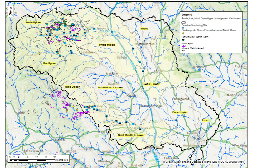
© Environment Agency
The tables below list the catchments (surface water bodies) that are polluted by target substances from abandoned metal mines in the SUNO management catchment. These tables highlight where there are known point sources (mine adits or mine drainage levels) and diffuse sources (mine wastes or spoil heaps) within the catchment. The Environment Agency is continuing to investigate point and diffuse sources within the SUNO management catchment by undertaking a series of catchment characterisation studies. These studies will help us identify which sources of metals need to be tackled to achieve the long-term statutory target.
Swale Upper operational catchment: sources of metal pollution
Table 1 summarises which type of pollution sources from abandoned metal mines have been identified within the catchments (surface water bodies) in the Swale Upper operational catchment.
Table 1. Summary of metal pollution sources in the Swale Upper operational catchment
| Catchment (Surface water body) | Point sources of pollution | Diffuse sources of pollution |
|---|---|---|
| Swale from Stonesdale Beck to Muker Beck | None identified | Yes |
| Gunnerside Gill from Source to River Swale | Yes | Yes |
| Barney Beck/Hard Level Gill from Source to River Swale | Yes | Yes |
| Arkle Beck from Source to River Swale | Yes | Yes |
| Marske Beck from Source to River Swale | Yes | Yes |
Swale Middle operational catchment: sources of metal pollution
Table 2 summarises which type of pollution sources from abandoned metal mines have been identified within the catchments (surface water bodies) in the Swale Middle operational catchment.
Table 2. Summary of metal pollution sources in the Swale Middle operational catchment
| Catchment (Surface water body) | Point sources of pollution | Diffuse sources of pollution |
|---|---|---|
| Swale from Muker Beck to Clapgate Beck | None identified: sources are upstream | None identified: sources are upstream |
Ure Upper operational catchment: sources of metal pollution
Table 3 summarises which type of pollution sources from abandoned metal mines have been identified within the catchments (surface water bodies) in the Ure Upper operational catchment.
Table 3. Summary of metal pollution sources in the Ure Upper operational catchment
| Catchment (Surface water body) | Point sources of pollution | Diffuse sources of pollution |
|---|---|---|
| Ure from Duerley Beck to Mill Beck | Further investigation required | Yes |
| Apedale Beck Catchment (tributary of River Ure) | Further investigation required | Yes |
Nidd Upper operational catchment: sources of metal pollution
Table 4 summarises which type of pollution sources from abandoned metal mines have been identified within the catchments (surface water bodies) in the Nidd Upper operational catchment.
Table 4. Summary of metal pollution sources in the Nidd Upper operational catchment
| Catchment (Surface water body) | Point sources of pollution | Diffuse sources of pollution |
|---|---|---|
| Ashfoldside Beck to River Nidd | Yes | Yes |
| River Nidd from Ashfoldside Beck to Birstwith | Yes | None identified |
Nidd Middle and Lower operational catchment: sources of metal pollution
Table 5 summarises which type of pollution sources from abandoned metal mines have been identified within the catchments (surface water bodies) in the Nidd Middle and Lower operational catchment.
Table 5. Summary of metal pollution sources in the Nidd Middle and Lower operational catchment
| Catchment (Surface water body | Point sources of pollution | Diffuse sources of pollution |
|---|---|---|
| Nidd from Burstwith to Oak Beck | None identified: sources are upstream | None identified: sources are upstream |
| Nidd from Oak Beck to Low Bridge on Briggate (Knaresborough) | None identified: sources are upstream | None identified: sources are upstream |
Baseline monitoring
The objective of the baseline monitoring was to establish the upstream and downstream extent of surface waters polluted by the target substances from abandoned metal mines. We selected the baseline monitoring sites by first completing a desk study to review previous water quality data, maps and reports. We then made initial site visits to collect samples and to assess the suitability of the site for continued sampling. Generally, at least twelve water quality samples were then collected from each monitoring site.
Within the SUNO management catchment, water quality monitoring was undertaken in 6 of the 10 operational catchments (Swale Upper, Swale Middle, Swale Lower, Ure Upper, Nidd Upper and Nidd Middle Lower). These are highlighted in Figure 1. We did not carry out monitoring in operational catchments where there is either no historical metal mining within the catchment or where existing monitoring data shows that rivers in these catchments are not polluted by abandoned metal mines.
In total, 58 monitoring sites were selected across the SUNO management catchment to determine the baseline length of rivers polluted by target substances from abandoned metal mines. The locations of these monitoring sites are shown in Figure 1.
Water quality data collected between 1 January 2022 and 31 March 2024 have been used to determine and validate the baseline length of rivers and estuaries considered polluted in 2022. The length of rivers polluted by abandoned metal mines fluctuates in response to natural variation in rainfall and river flows. However, this length will not materially change unless remediation measures like mine water treatment schemes or diffuse interventions are installed to decrease inputs of metals. Therefore, data collected after 31 December 2022 are considered to be representative of rivers, provided no new remediation measures had been constructed since 2022. No new remediation measures have been constructed in the SUNO management catchment since 2022.
Water quality monitoring results
In the SUNO management catchment, the target substances measured were cadmium, copper, lead, nickel and zinc. We did not undertake testing for arsenic in this management catchment since historical monitoring data and knowledge of the local geology across the catchment indicated that no rivers are polluted by arsenic in this management catchment.
The baseline water quality data for all monitoring sites are available on the Environment Agency’s public water quality archive.
For a river water quality sample to be considered polluted, concentrations of one or more of the target substances must exceed the relevant EQS set by government when assessed as an “annual average”. The EQS are set out in The Water Framework Directive (Standards and Classification) Directions (England and Wales) 2015.
The EQS are derived using ecotoxicology data and set at a level that should prevent harmful environmental impacts. When the concentration of a substance in a water sample is higher than the EQS, adverse impacts on the aquatic ecosystem can occur, and the sample is considered to be polluted.
To understand the severity of pollution, we calculated a numeric “pollution level” by dividing the measured concentration of the target substances by the EQS. If the pollution level is greater than 1, the monitoring site is considered polluted by that target substance. Therefore, the higher the numeric pollution level, the greater the likelihood of harm to aquatic life.
Baseline polluted river length: SUNO management catchment
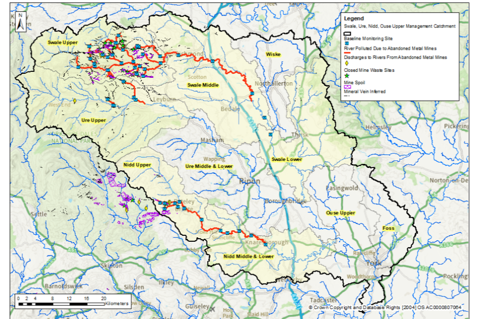
Our detailed monitoring across a range of flow conditions between January 2022 and March 2024 shows that in the SUNO management catchment, the baseline length of polluted rivers for the abandoned metal mines target is 206km.
Figure 2 shows the rivers in the SUNO management catchment that are polluted by target substances from abandoned metal mines.
Figure 2. The baseline length of rivers polluted by target substances from abandoned metal mines in the SUNO management catchment is 206km
© Environment Agency
Table 6 shows the river length (in km) that are polluted by each of the target substances within the SUNO management catchment. In general, the most polluted rivers are impacted by more than one target substance.
Table 6. River length (in km) polluted by each of the target substances within the SUNO management catchment.
| Target substance | Polluted river length (km) | Pollution level: less than 3 times | Pollution level: 3 to 5 times | Pollution level: greater than 5 times |
|---|---|---|---|---|
| Cadmium (Cd) | 193 | 96 | 50 | 47 |
| Lead (Pb) | 118 | 76 | 13 | 29 |
| Nickel (Ni) | 0 | 0 | 0 | 0 |
| Zinc (Zn) | 129 | 75 | 35 | 19 |
| Copper (Cu) | 3 | 3 | 0 | 0 |
Rivers polluted by abandoned metal mines: SUNO management catchment
Swale Upper, Middle and Lower operational catchments: baseline polluted rivers
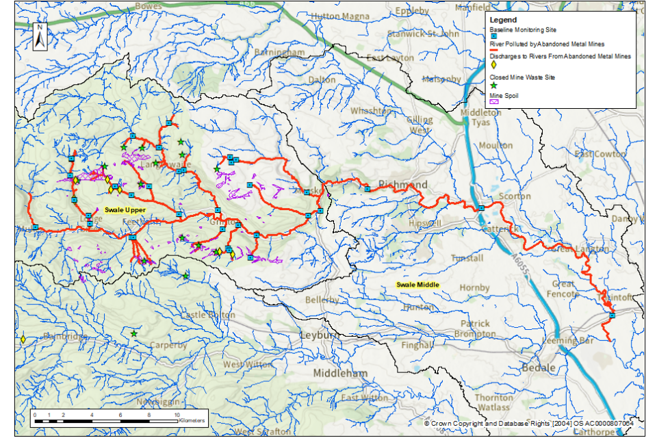
The River Swale is polluted by zinc, lead and cadmium at all monitoring sites from upstream of the Swale at Muker until between Morton-on-Swale and Maunby. Many of the tributaries are polluted by the same substances from near to their headwaters until they join the River Swale.
Figure 3 shows the baseline polluted rivers in this operational catchment.
Figure 3. The baseline length of rivers polluted by target substances from abandoned metal mines in the Swale Upper, Middle and Lower operational catchments is 148km
© Environment Agency
It should be noted that due to close proximity of some of the sampling points to each other, some of the sampling point markers on this map (blue squares) may overlap.
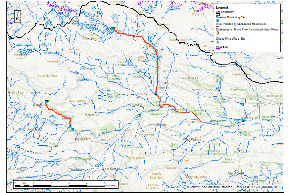
Ure Upper operational catchment
Two tributaries of the River Ure (Eller Beck and Apedale Beck) are polluted by zinc, lead and cadmium. However, only a small length of the River Ure is polluted before dilution with cleaner water decreases the pollution level to less than 1.
Figure 4 shows the baseline polluted rivers in this operational catchment.
Figure 4. The baseline length of rivers polluted by target substances from abandoned metal mines in the Ure Upper operational catchment is 14km
© Environment Agency
Nidd Upper, Middle and Lower operational catchment
The River Nidd is polluted by cadmium from upstream of Pateley Bridge (where it is joined by Ashfoldside Beck) until Knaresborough. The Ashfoldside Beck, Brandstone Beck and Rash Dike tributaries are polluted by zinc, lead and cadmium.
Figure 5 shows the baseline polluted rivers in this operational catchment.
Figure 5. The baseline length of rivers polluted by target substances from abandoned metal mines in the Nidd Upper, Middle and Lower operational catchments is 44km
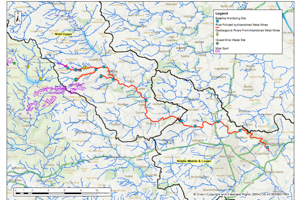
© Environment Agency