Tyne management catchment: baseline length of rivers and estuaries polluted by abandoned metal mines
Published 12 March 2025
Applies to England

© Crown copyright 2025
This publication is licensed under the terms of the Open Government Licence v3.0 except where otherwise stated. To view this licence, visit nationalarchives.gov.uk/doc/open-government-licence/version/3 or write to the Information Policy Team, The National Archives, Kew, London TW9 4DU, or email: psi@nationalarchives.gov.uk.
Where we have identified any third party copyright information you will need to obtain permission from the copyright holders concerned.
This publication is available at https://www.gov.uk/government/publications/abandoned-metal-mines-in-england-baseline-length-of-rivers-and-estuaries-polluted-by-harmful-metals/tyne-management-catchment-baseline-length-of-rivers-and-estuaries-polluted-by-abandoned-metal-mines
This is one of 20 reports, one for each polluted management catchment, on the water quality monitoring undertaken by the Environment Agency to determine the baseline length of rivers and estuaries considered polluted by any of the Environment Act target substances from abandoned metal mines in 2022.
A length of river or estuary is considered polluted where the concentration of one or more of the 6 target substances (arsenic, cadmium, copper, lead, nickel and zinc) exceeds the relevant Environmental Quality Standard (EQS). EQS concentrations are based on ecotoxicology data and set by government at a level that should prevent harmful environmental impacts. When the concentration of a substance in a water sample is higher than the EQS, adverse impacts on the aquatic ecosystem can be expected. The relevant EQS for each target substance are set out in The Water Framework Directive (Standards and Classification) Directions (England and Wales) 2015.
The purpose of calculating this baseline was to enable measurement of the statutory abandoned metal mines target set out in Part 4 of the Environmental Targets (Water) (England) Regulations 2023. This regulation requires that the combined length of English rivers and estuaries polluted by the target substances from abandoned metal mines is, by 31 December 2038, at least 50% lower than the baseline.
In the Tyne management catchment, the baseline length of polluted rivers for the abandoned metal mines water target is 217km. We will aim to identify the key sources of metal pollution in this management catchment by carrying out detailed monitoring investigations.
You can find further background and context on the Environment Act abandoned metal mines water target in the national baseline report which should be read together with this report.
The Tyne management catchment
The Tyne management catchment covers an area of approximately 2,940km2 and encompasses areas of Northumberland National Park and the North Pennines National Landscape. Please go to Tyne Management Catchment on the Catchment Data Explorer for an interactive map showing the 9 operational catchments that make up the management catchment.
Metal mining in the Tyne management catchment
The rich metal ore deposits in the headwaters of the Tyne, Wear and Tees catchments meant that in the 1800s, the North Pennines was one of the heavily industrialised upland landscapes in England. The first written evidence of mining in the North Pennines is recorded in a lease from 1130 which refers to Carlisle Silver mines, thought to refer to the silver rich mineral deposits on Alston Moor. There is circumstantial evidence of the mining history extending back to the Romans due to the proximity of Roman occupied sites, however, this has not been confirmed (see OREsome project – North Pennines National Landscape).
Mining in the area expanded rapidly from around 1690 when mineral ownership passed from the Crown to landowners. Driving of Rampgill level at Nenthead (Nent catchment) started in 1690 and Barney Craig level at Carrshield started in 1760. Numerous other mines and smelt mills were opened in the area and production from the London Lead Company peaked in the 1820s. Production dwindled until the late 19th century with only a handful of mining operations continuing into the early 20th century. The final phase of mineral extraction involved reprocessing of mine waste heaps to recover zinc and fluorspar, which ceased in the 1980s. For more information, please visit North Pennines - Northern Mine Research Society or Kincey and others, 2022, Metals, mines and moorland: the changing lead mining landscapes of the North Pennines, UK, 1700-1948.
This intensive mining activity transformed the physical landscape, permanently altered how groundwater discharged to rivers and left extensive areas of metal-contaminated mine wastes on which unusual calaminarian (‘metal-loving’) plants thrive, often designated as sites of special scientific interest. Many former mine sites are protected as scheduled monuments for their industrial archaeological significance.
Figure 1 shows the locations of mineral veins, known mine water discharges, closed mine waste facilities known to be causing serious environmental harm, and recorded areas of abandoned mine wastes (mining spoil) in the Tyne management catchment.
This information has been gathered from various sources including:
- BGS Geological mapping - GeoIndex - British Geological Survey
- Prioritisation of abandoned non-coal mine impacts on the environment
- Inventory of closed mining waste facilities causing serious environmental impacts
- Defra-funded ‘Source apportionment of pollution from non-coal mines’ research project by Newcastle University and Hull University (unpublished)
- Environment Agency water quality data archive
As we can see from Figure 1 most of the historical mining activities in the Tyne management catchment were concentrated in the South Tyne operational catchment.
Figure 1. Map showing the abandoned metal mines, mineral veins and baseline river monitoring sites in the Tyne management catchment
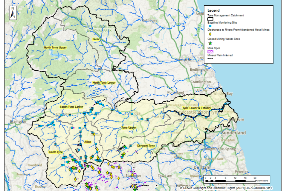
© Environment Agency
The tables below list the catchments (surface water bodies) polluted by abandoned metal mines in the Tyne management catchment. The tables highlight known point sources (mine adits or mine drainage levels) and diffuse sources (mine wastes or spoil) within the catchment. The Environment Agency is continuing to investigate point and diffuse sources within the Tyne management catchment by undertaking a series of catchment characterisation studies. These studies will help us identify which sources of metals need to be tackled to achieve the long-term statutory target.
South Tyne Upper operational catchment: sources of metal pollution
Table 1 summarises which type of pollution sources from abandoned metal mines have been identified within the catchments (surface water bodies) in the South Tyne Upper operational catchment.
Table 1. Summary of metal pollution sources in the South Tyne Upper operational catchment
| Catchment (Surface water body) | Point sources of pollution | Diffuse sources of pollution |
|---|---|---|
| Nent from Source to South Tyne | Yes | Yes |
| South Tyne from Cross Gill to Black Burn (Aleson) | Yes | Yes |
| South Tyne from Blackburn to Tipalt Burn | None identified: sources are upstream | Yes |
| Hartley Burn from Source to Black Burn | None identified: sources are upstream | Yes |
| South Tyne from Source to Cross Gill | Yes | Yes |
| Hartley Burn from Black Burn to South Tyne | None identified: sources are upstream | None identified: sources are upstream |
| Black Burn from Source to Aglionby Beck | Further investigation required | Further investigation required |
| Aglionby Beck (trib of Black Burn) | Further investigation required | Further investigation required |
Allen operational catchment: sources of metal pollution
Table 2 summarises which type of pollution sources from abandoned metal mines have been identified within the catchments (surface water bodies) in the Allen operational catchment.
Table 2 Summary of metal pollution sources in the Allen operational catchment
| Catchment (Surface water body) | Point sources of pollution | Diffuse sources of pollution |
|---|---|---|
| West Allen from Source to Wellhope Burn | Yes | Yes |
| Allen from Source to West Allen | Yes | Yes |
| Wellhope Burn | None identified | Yes |
| West Allen from Wellhope to Allen | None identified: sources are upstream | Yes |
| Allen from West Allen to South Tyne | None identified: sources are upstream | None identified: sources are upstream |
South Tyne Lower operational catchment: sources of metal pollution
Table 3 summarises which type of pollution sources from abandoned metal mines have been identified within the catchments (surface water bodies) in the South Tyne Lower operational catchment.
Table 3 Summary of metal pollution sources in the South Tyne Lower operational catchment
| Catchment (Surface water body) | Point sources of pollution | Diffuse sources of pollution |
|---|---|---|
| Newbrough Burn | Yes | Yes |
| Honeycrook Burn | None identified | Yes |
| South Tyne from Tipalt to Allen | None identified: sources are upstream | None identified: sources are upstream |
| South Tyne from Allen to North Tyne | None identified: sources are upstream | None identified: sources are upstream |
Derwent Tyne operational catchment: sources of metal pollution
Table 4 summarises which type of pollution sources from abandoned metal mines have been identified within the catchments (surface water bodies) in the Derwent Tyne operational catchment.
Table 4. Summary of metal pollution sources in the Derwent Tyne operational catchment
| Catchment (Surface water body) | Point sources of pollution | Diffuse sources of pollution |
|---|---|---|
| Derwent from Nookton Burn to Burnhope burn | Further investigation required | Yes |
Tyne Estuary operational catchment: sources of metal pollution
Table 5 summarises which type of pollution sources from abandoned metal mines have been identified within the catchments (surface water bodies) in the Tyne Estuary operational catchment.
Table 5. Summary of metal pollution sources in the Tyne Estuary operational catchment
| Catchment (Surface water body) | Point sources of pollution | Diffuse sources of pollution |
|---|---|---|
| Tyne Estuary | None identified: sources are upstream | None identified: sources are upstream |
Baseline monitoring
The objective of the baseline monitoring was to establish the upstream and downstream extent of surface waters polluted by the target substances from abandoned metal mines. We selected the baseline monitoring sites by first completing a desk study to review previous water quality data, maps and reports. We then made initial site visits to collect samples and to assess the suitability of the site for continued sampling. Generally, at least twelve water quality samples were then collected from each monitoring site.
Within the Tyne management catchment, water quality monitoring was undertaken in 5 of the 9 operational catchments (Tyne). These catchments are highlighted in Figure 1. We did not carry out monitoring in operational catchments where there is either no historical metal mining within the catchment or a combination of current and historical monitoring data shows that waterbodies within these catchments are not polluted by abandoned metal mines.
In total, 79 monitoring sites were selected across the Tyne management catchment to determine the baseline length of rivers polluted by target substances from abandoned metal mines. The locations of these monitoring sites are shown in Figure 1.
Water quality data collected between 1 January 2022 and 31 March 2024 have been used to determine and validate the baseline length of rivers and estuaries considered polluted in 2022. The length of rivers polluted by abandoned metal mines fluctuates in response to natural variation in rainfall and river flows. However, this length will not materially change unless remediation measures like mine water treatment schemes or diffuse interventions are installed to decrease inputs of metals. Therefore, data collected after 31 December 2022 are considered to be representative of rivers, provided no new remediation measures had been constructed since 2022. Where new remediation measures have been constructed in the Tyne management catchment since 2022, the baseline was determined only using water quality data collected before these measures were completed.
Water quality monitoring results
In the Tyne management catchment, the target substances measured were cadmium, copper, lead, nickel and zinc. We did not undertake testing for arsenic in this management catchment since historical monitoring data and knowledge of the local geology across the catchment indicated that no rivers are polluted by arsenic in this management catchment.
The baseline water quality data for all monitoring sites are available on the Environment Agency’s public water quality archive.
For a river water quality sample to be considered polluted, concentrations of one or more of the target substances must exceed the relevant EQS set by government when assessed as an “annual average”. The EQS are set out in The Water Framework Directive (Standards and Classification) Directions (England and Wales) 2015.
The EQS are derived using ecotoxicology data and set at a level that should prevent harmful environmental impacts. When the concentration of a substance in a water sample is higher than the EQS, adverse impacts on the aquatic ecosystem can occur, and the sample is considered to be polluted.
To understand the severity of pollution, we calculated a numeric “pollution level” by dividing the measured concentration of the target substances by the EQS. If the pollution level is greater than 1, the monitoring site is considered polluted by that target substance. Therefore, the higher the numeric pollution level, the greater the likelihood of harm to aquatic life.
Baseline polluted river length: Tyne management catchment
Our detailed monitoring across a range of flow conditions between January 2022 and March 2024 shows that in the Tyne management catchment, the baseline length of polluted rivers for the abandoned metal mines target is 217km.
Figure 2 shows the rivers in the Tyne management catchment that are polluted by target substances from abandoned metal mines.
Figure 2. The baseline length of rivers polluted by target substances from abandoned metal mines in the Tyne management catchment is 217km
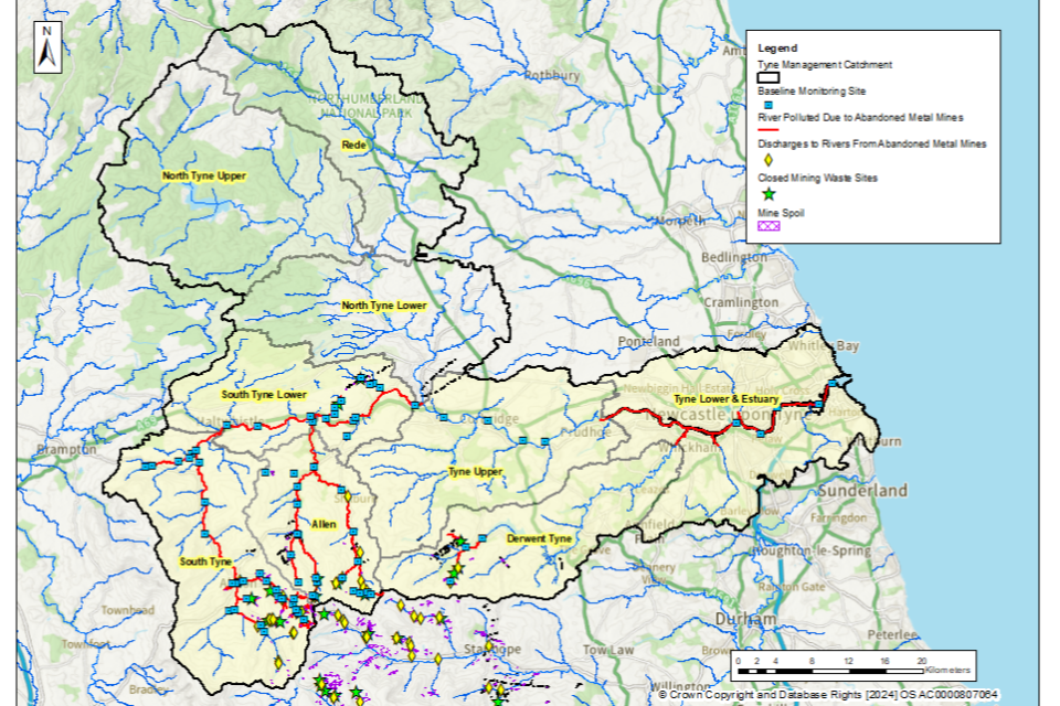
© Environment Agency
It should be noted that due to close proximity of some of the sampling points to each other, some of the sampling point markers on this map (blue squares) may overlap.
Table 6 shows the river length (in km) that are polluted by each of the target substances within the Tyne management catchment. In general, the most polluted rivers are impacted by more than one target substance.
Table 6. River length (in km) polluted by each of the target substances within the Tyne management catchment
| Target substance | Polluted river length (km) | Pollution level: less than 3 times | Pollution level: 3 to 5 times | Pollution level: greater than 5 times |
|---|---|---|---|---|
| Cadmium (Cd) | 184 | 98 | 36 | 50 |
| Lead (Pb) | 89 | 67 | 8 | 14 |
| Nickel (Ni) | 2 | 2 | 0 | 0 |
| Zinc (Zn) | 209 | 108 | 34 | 67 |
| Copper (Cu) | 0 | 0 | 0 | 0 |
Rivers polluted by abandoned metal mines: Tyne management catchment
South Tyne Upper operational catchment: baseline polluted rivers
The River South Tyne is polluted by metals from the point at which Garrigill Burn enters the river. The entire length of the River South Tyne is polluted by cadmium and zinc, with sources of metals in several tributaries, most notably the River Nent which is severely polluted by zinc and cadmium, and to a lesser extent, lead. The River South Tyne is no longer polluted by lead at Featherstone.
Figure 3 shows the baseline polluted rivers in this operational catchment.
Figure 3. The baseline length of rivers polluted by target substances from abandoned metal mines in the South Tyne Upper operational catchment is 76km

© Environment Agency
It should be noted that due to close proximity of some of the sampling points to each other, some of the sampling point markers on this map (blue squares) may overlap.
Allen operational catchment: baseline polluted rivers
The River West Allen is polluted from its source. The 2 tributaries, Coal Cleugh and Alston Cleugh that form the West Allen, are both polluted at the most upstream point that is accessible. Pollution from these tributaries extends to the bottom of the catchment and is supplemented by other point and diffuse sources along the way.
The River East Allen starts being polluted by metals where the East End Burn tributary enters the River East Allen in the village of Allenheads. This pollution continues until the East and West Allen converge to form the River Allen. The River Allen is also polluted by metals along its entire length until it meets the South Tyne. The highest pollution levels are seen in the upper catchments, particularly the West Allen. At the point the River Allen meets the South Tyne, it remains polluted by zinc and cadmium but is no longer polluted by lead.
Figure 4 shows the baseline polluted rivers in this operational catchment.
Figure 4. The baseline length of rivers polluted by target substances from abandoned metal mines in the Allen operational catchment is 61km

© Environment Agency
South Tyne Lower operational catchment: baseline polluted rivers
The River South Tyne is polluted by zinc and cadmium throughout this operational catchment. The watercourse is not polluted for lead in this catchment. Tributaries including the River Allen (see previous section), Honeycrook Burn and Newbrough Burn are also polluted, and also contribute to pollution in the River South Tyne. Figure 5 shows the baseline polluted rivers in this operational catchment.
Figure 5. The baseline length of rivers polluted by target substances from abandoned metal mines in the South Tyne Lower operational catchment is 38km
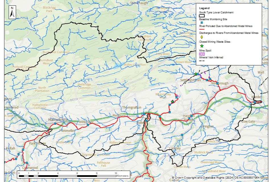
© Environment Agency
Derwent Tyne operational catchment: baseline polluted rivers
The River Derwent is polluted by cadmium, zinc and lead from where Bolts Burn and Shildon Burn join the main river until it flows into the Derwent Reservoir. The highest pollution levels are found in Shildon Burn and Bolts Burn.
Figure 6 shows the baseline polluted rivers in this operational catchment.
Figure 6. The baseline length of rivers polluted by target substances from abandoned metal mines in the Derwent Tyne operational catchment is 13km
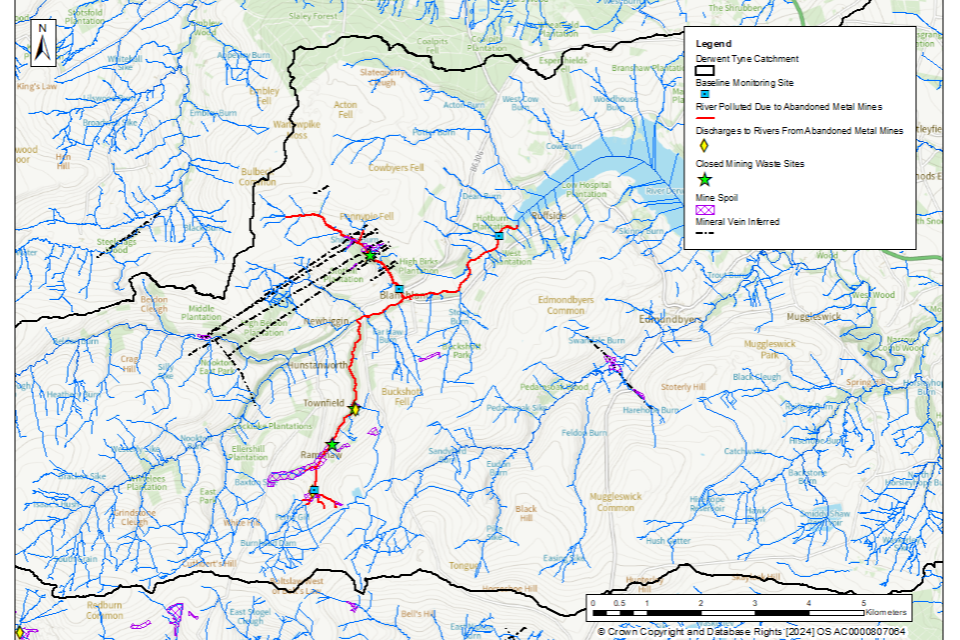
© Environment Agency
Tyne Estuary operational catchment: baseline polluted estuary
The Tyne Estuary is polluted by zinc and cadmium from the freshwater limit near Wylam down to the monitoring location off Whitehill Point near Tyne Dock.
Figure 7 shows the baseline polluted estuary in this operational catchment.
Figure 7. The baseline length of rivers polluted by target substances from abandoned metal mines in the Tyne Estuary operational catchment is 29km
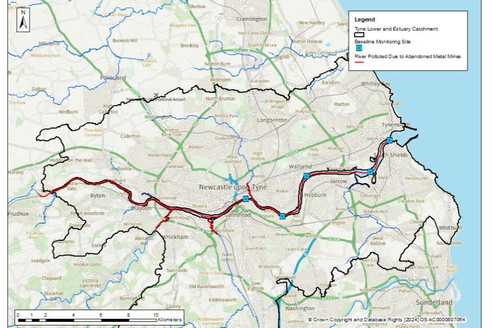
© Environment Agency