West Cornwall and Fal management catchment: baseline length of rivers and estuaries polluted by abandoned metal mines
Published 12 March 2025
Applies to England

© Crown copyright 2025
This publication is licensed under the terms of the Open Government Licence v3.0 except where otherwise stated. To view this licence, visit nationalarchives.gov.uk/doc/open-government-licence/version/3 or write to the Information Policy Team, The National Archives, Kew, London TW9 4DU, or email: psi@nationalarchives.gov.uk.
Where we have identified any third party copyright information you will need to obtain permission from the copyright holders concerned.
This publication is available at https://www.gov.uk/government/publications/abandoned-metal-mines-in-england-baseline-length-of-rivers-and-estuaries-polluted-by-harmful-metals/west-cornwall-and-fal-management-catchment-baseline-length-of-rivers-and-estuaries-polluted-by-abandoned-metal-mines
This is one of 20 reports, one for each polluted management catchment, on the water quality monitoring undertaken by the Environment Agency to determine the baseline length of rivers and estuaries considered polluted by any of the Environment Act target substances from abandoned metal mines in 2022.
A length of river or estuary is considered polluted where the concentration of one or more of the 6 target substances (arsenic, cadmium, copper, lead, nickel and zinc) exceeds the relevant Environmental Quality Standard (EQS). EQS concentrations are based on ecotoxicology data and set by government at a level that should prevent harmful environmental impacts. When the concentration of a substance in a water sample is higher than the EQS, adverse impacts on the aquatic ecosystem can be expected. The relevant EQS for each target substance are set out in The Water Framework Directive (Standards and Classification) Directions (England and Wales) 2015. The purpose of calculating this baseline was to enable measurement of the statutory abandoned metal mines target set out in Part 4 of the Environmental Targets (Water) (England) Regulations 2023. This regulation requires that the combined length of English rivers and estuaries polluted by the target substances from abandoned metal mines is, by 31 December 2038, at least 50% lower than the baseline.
In the West Cornwall and Fal management catchment, the baseline length of polluted rivers for the abandoned metal mines water target is 264km. We will aim to identify the key sources of metal pollution in this management catchment by carrying out detailed monitoring investigations.
You can find further background and context on the Environment Act abandoned metal mines water target in the national baseline report which should be read together with this report.
The West Cornwall and Fal management catchment
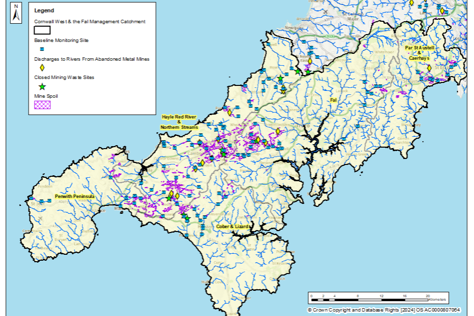
The West Cornwall and Fal management catchment covers an area of approximately 1,500km2 and includes areas of the Cornwall National Landscape. Please go to Cornwall West and the Fal Catchment on the Catchment Data Explorer for an interactive map showing the 5 operational catchments that make up the management catchment. The boundary of the West Cornwall and Fal management catchment and all 5 operational catchments are highlighted in Figure 1.
Metal mining in the West Cornwall and Fal management catchment
In West Cornwall, there has been evidence of tin and copper mining since the Bronze Age. Mining for tin and copper continued during the medieval period and grew throughout the 16th and 17th centuries, peaking in the 18th and early 19th centuries to coincide with the industrial revolution, with West Cornwall becoming one of the most important ore producing regions across the globe (for more information, please visit Cornish Mining World Heritage Site). During this time some mining also occurred, to a lesser extent, for arsenic, zinc, silver and lead. From the late 19th century onwards, mining in West Cornwall declined, with the closure of many mines at the end of the 19th century, and the last tin mine, South Crofty, closed in 1998. In late 2023, the South Crofty mine was re-opened by Cornish Metals Inc. (for more information, visit Cornish Metals - South Crofty Tin Project).
Figure 1 shows the locations of mineral veins, known mine water discharges, closed mine waste facilities known to be causing serious environmental harm, and recorded areas of abandoned mine wastes (mining spoil) in the West Cornwall and Fal management catchment.
This information has been gathered from various sources including:
- BGS Geological mapping - GeoIndex - British Geological Survey
- Prioritisation of abandoned non-coal mine impacts on the environment
- Inventory of closed mining waste facilities causing serious environmental impacts
- Defra-funded ‘Source apportionment of pollution from non-coal mines’ research project by Newcastle University and Hull University (unpublished)
- Environment Agency water quality data archive
As we can see in Figure 1, mining occurred extensively across the West Cornwall and Fal management catchment, with most historical mining activities occurring in the Hayle, Red River and Northern Streams, and Fal operational catchments.
Figure 1. Map showing the abandoned metal mines, mineral veins and baseline river monitoring sites in the West Cornwall and Fal management catchment
© Environment Agency
The tables below list the catchments (surface water bodies) that are polluted by target substances from abandoned metal mines in the West Cornwall and Fal management catchment. These tables highlight where there are known point sources (mine adits or mine drainage levels) and diffuse sources (mine wastes or spoil heaps) within the catchment. The Environment Agency is continuing to investigate point and diffuse sources within the West Cornwall and Fal management catchment by undertaking a series of catchment characterisation studies. These studies will help us identify which sources of metals need to be tackled to achieve the long-term statutory target.
Par St Austell and Caerhays operational catchment: sources of metal pollution
Table 1 summarises which type of pollution sources from abandoned metal mines have been identified within the catchments (surface water bodies) in the Par St Austell and Caerhays operational catchment.
Table 1. Summary of metal pollution sources in the Par St Austell and Caerhays operational catchment
| Catchment (Surface water body) | Point sources of pollution | Diffuse sources of pollution |
|---|---|---|
| Crinnis Stream | Yes | Further Investigation Required |
| Tywardreath Stream | Yes | Further Investigation Required |
Fal operational catchment: sources of metal pollution
Table 2 summarises which type of pollution sources from abandoned metal mines have been identified within the catchments (surface water bodies) in the Fal operational catchment.
Table 2. Summary of metal pollution sources in the Fal operational catchment
| Catchment (Surface water body) | Point sources of pollution | Diffuse sources of pollution |
|---|---|---|
| Gwindra Stream | Yes | No |
| Lower River Fal | None identified: sources are upstream | None identified: sources are upstream |
| Calenick Stream | Yes | Yes |
| Upper Carnon River | Yes | Yes |
| Lower Carnon River | Yes | Yes |
| Hicks Mill Stream | Yes | Yes |
Hayle Red River and Northern Streams operational catchment: sources of metal pollution
Table 3 summarises which type of pollution sources from abandoned metal mines have been identified within the catchments (surface water bodies) in the Hayle Red River and Northern Streams operational catchment.
Table 3. Summary of metal pollution sources in the Hayle Red River and Northern Streams operational catchment
| Catchment (Surface water body) | Point sources of pollution | Diffuse sources of pollution |
|---|---|---|
| Angarrack Stream | Yes | Yes |
| Bolingey Stream | Yes | Yes |
| Hayle | Yes | Further investigation required |
| Holywell Stream | Yes | Yes |
| Portreath Stream | Yes | Yes |
| Red River (Upper) | Yes | Yes |
| Red River (Lower) | Yes | Yes |
| Roseworthy Stream | Yes | Yes |
This operational catchment contains the following polluted rivers that are included in coastal water bodies in the South West River Basin Management Plan rather than surface water bodies.
| Catchment (Surface water body) | Point sources of pollution | Diffuse sources of pollution |
|---|---|---|
| Porthtowan Stream | Yes | Yes |
| Trevellas Stream | Further investigation required | Yes |
| Perranporth Stream | Further investigation required | Further investigation required |
Penwith Peninsula operational catchment: sources of metal pollution
Table 4 summarises which type of pollution sources from abandoned metal mines have been identified within the catchments (surface water bodies) in the Penwith operational catchment.
Table 4. Summary of key metal pollution sources in the Penwith Peninsula operational catchment
| Catchment (Surface water body) | Point sources of pollution | Diffuse sources of pollution |
|---|---|---|
| Marazion River | Yes | Yes |
Cober and Lizard operational catchment: sources of metal pollution
Table 5 summarises which type of pollution sources from abandoned metal mines have been identified within the catchments (surface water bodies) in the Cober and Lizard operational catchment.
Table 5. Summary of key metal pollution sources in the Cober and Lizard operational catchment
| Catchment (Surface water body) | Point sources of pollution | Diffuse sources of pollution |
|---|---|---|
| Upper River Cober | Further investigation required | Yes |
| Lower River Cober | Further investigation required | Further investigation required |
| Porthleven Stream | Yes | Yes |
Baseline monitoring
The objective of the baseline monitoring was to establish the upstream and downstream extent of surface waters polluted by the target substances from abandoned metal mines. We selected the baseline monitoring sites by first completing a desk study to review previous water quality data, maps and reports. We then made initial site visits to collect samples and to assess the suitability of the site for continued sampling. Generally, at least twelve water quality samples were then collected from each monitoring site.
Within the West Cornwall and Fal management catchment, water quality monitoring was undertaken in all 5 operational catchments, highlighted in Figure 1.
In total, 162 monitoring sites were selected across the West Cornwall and Fal management catchment to determine the baseline length of rivers polluted by target substances from abandoned metal mines. The locations of these monitoring sites are shown in Figure 1.
Water quality data collected between 1 January 2022 and 31 March 2024 have been used to determine and validate the baseline length of rivers and estuaries considered polluted in 2022. The length of rivers polluted by abandoned metal mines fluctuates in response to natural variation in rainfall and river flows. However, this length will not materially change unless remediation measures like mine water treatment schemes or diffuse interventions are installed to decrease inputs of metals. Therefore, data collected after 31 December 2022 are considered to be representative of rivers, provided no new remediation measures had been constructed since 2022. Where new remediation measures have been constructed in the West Cornwall and Fal management catchment since 2022, the baseline was determined only using water quality data collected before these measures were completed.
Water quality monitoring results
Within the West Cornwall and Fal management catchment, water quality monitoring was undertaken in all 5 operational catchments. These are highlighted in Figure 1. We did not carry out monitoring in water bodies where there is either no historical metal mining or where existing monitoring data shows that rivers are not polluted by abandoned metal mines.
The baseline water quality data for all monitoring sites are available on the Environment Agency’s public water quality archive.
For a river water quality sample to be considered polluted, concentrations of one or more of the target substances must exceed the relevant EQS set by government when assessed as an “annual average”. The EQS are set out in The Water Framework Directive (Standards and Classification) Directions (England and Wales) 2015.
The EQS are derived using ecotoxicology data and set at a level that should prevent harmful environmental impacts. When the concentration of a substance in a water sample is higher than the EQS, adverse impacts on the aquatic ecosystem can occur, and the sample is considered to be polluted.
To understand the severity of pollution, we calculated a numeric “pollution level” by dividing the measured concentration of the target substances by the EQS. If the pollution level is greater than 1, the monitoring site is considered polluted by that target substance. Therefore, the higher the numeric pollution level, the greater the likelihood of harm to aquatic life.
Baseline polluted river length: West Cornwall and Fal management catchment
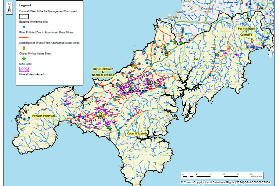
Our detailed monitoring across a range of flow conditions between January 2022 and March 2024 shows that in the West Cornwall and Fal management catchment, the baseline length of polluted rivers for the abandoned metal mines target is 264km.
Figure 2 shows the rivers in the West Cornwall and Fal management catchment that are polluted by target substances from abandoned metal mines.
Figure 2. The baseline length of rivers polluted by target substances from abandoned metal mines in the West Cornwall and Fal management catchment is 264km
© Environment Agency
Table 6 shows the river length (in km) that are polluted by each of the 6 target substances within the West Cornwall and Fal management catchment. In general, the most polluted rivers are impacted by more than one target substance.
Table 6. River length (in km) polluted by each of the target substances within the West Cornwall and Fal management catchment.
| Target substance | Polluted river length (km) | Pollution level: less than 3 times | Pollution level: 3 to 5 times | Pollution level: greater than 5 times |
|---|---|---|---|---|
| Cadmium (Cd) | 206 | 87 | 37 | 82 |
| Lead (Pb) | 20 | 13 | 3 | 4 |
| Nickel (Ni) | 68 | 54 | 6 | 8 |
| Zinc (Zn) | 249 | 42 | 48 | 159 |
| Copper (Cu) | 173 | 76 | 13 | 84 |
| Arsenic (As) | 4 | 4 | 0 | 0 |
Rivers polluted by abandoned metal mines: West Cornwall and Fal management catchment
Par St Austell and Caerhays operational catchment: baseline polluted length
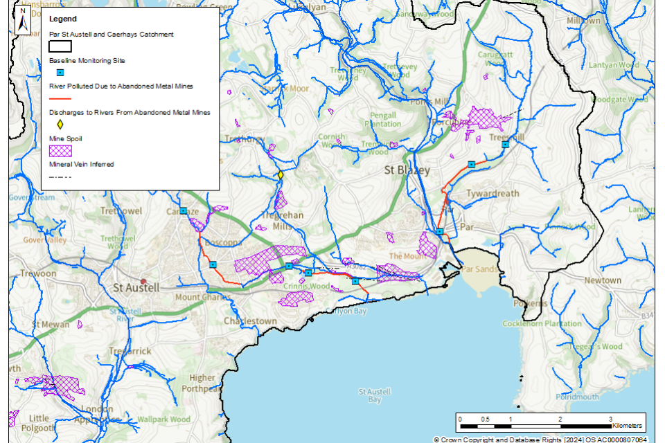
The Crinnis River is polluted for copper and zinc for much of its length. In the upper stretches of the river, these failures are likely due to the local geology and the naturally elevated metal concentrations in the bedrock as there is no known mining activity in the upper stretches. However, in the lower stretches of the river, there are inputs from abandoned mines located in the Cuddra Plantation which are polluting the river with metals.
The lower Tywardreath Stream is polluted by copper, zinc, and cadmium, below the input from the abandoned Fowey Consols mine. The upper stretches of the stream, above the old mine, are not polluted by any target substances.
Figure 3 shows the baseline polluted rivers in this operational catchment.
Figure 3. The baseline length of rivers polluted by target substances from abandoned metal mines in the Par St Austell and Caerhays operational catchment is 6km
© Environment Agency
It should be noted that due to close proximity of some of the sampling points to each other, some of the sampling point markers on this map (blue squares) may overlap.
Fal operational catchment: baseline polluted length
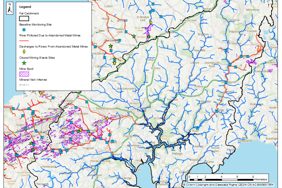
The Lower River Fal is polluted by zinc below the confluence of the Gwindra Stream to near the tidal limit. The Gwindra Stream itself is polluted by zinc and cadmium below the confluence with the metal polluted Coombe Stream. Most of this metal pollution is discharging from the Coombe Adit.
The Calenick Stream is polluted by zinc and cadmium along its entire length, with failures of the EQS for copper and lead in its lower stretches. There are several point source mine water discharges in this stream that contribute to the metal pollution.
The Carnon River, and its tributaries, are heavily polluted by the target substances, with especially high pollution levels for copper, zinc, and cadmium in the lower half of the river, as well as in the Hicks Mill Stream. The lower reaches of the River Carnon are also polluted by arsenic. Most of the metals in the lower Carnon River are discharged from the County Adit, a large network of about 40 miles of underground workings that historically drained water from many mines in the region. However, the Carnon River is also polluted by the target substances above the County Adit, to its headwaters at Blackwater. A major source of metals in the Hicks Mill Stream is from the Tresavean Adit discharge, although metal pollution is also observed upstream of there.
Figure 4 shows the baseline polluted rivers in this operational catchment.
Figure 4. The baseline length of rivers polluted by target substances from abandoned metal mines in the Fal operational catchment is 69km
© Environment Agency
It should be noted that due to close proximity of some of the sampling points to each other, some of the sampling point markers on this map (blue squares) may overlap.
Hayle Red River and Northern Streams operational catchment: baseline polluted rivers
Many rivers in the Hayle Red River and Northern Streams operational catchment are polluted by one or more of the target substances. On the north Cornwall coast, the Holywell Stream is polluted by zinc, lead, and cadmium throughout most of its length. Most of the Bolingey Stream catchment is polluted by zinc and cadmium, with high zinc and cadmium pollution levels in the headwaters of West Chiverton stream. The entire length of the Perranporth Stream is polluted by zinc and cadmium. The whole Trevallas Stream is polluted by zinc and cadmium, with the pollution level increasing down the catchment; most of this stream is also polluted by copper, nickel and lead. The entire Porthtowan Stream is polluted by zinc and cadmium, with the lower reaches also polluted by nickel and very high levels of copper.
The Portreath and Redruth Streams are polluted with the target substances across the catchment, with especially high copper pollution at the furthest upstream sampling locations. The upper stretch of the Redruth Stream is also polluted by arsenic.
The Red River is polluted by copper, zinc, and cadmium across most of the catchment, although the Praze River tributary is not polluted. The Treskillard Stream, near the top of the Red River, is polluted by copper, and is a major source of metals in the upper stretches of the watercourse. In the lower stretches of the Red River, the discharge from Dolcoath Adit, which drains the South Crofty mine and other abandoned workings, is a major source of metal pollution.
The Angarrack Stream is polluted with copper, zinc, cadmium and nickel across its catchment. Most of the River Hayle is polluted by copper, zinc, cadmium and nickel. There are many sources of metal pollution from abandoned metal mines in these catchments.
Figure 5 shows the baseline polluted rivers in this operational catchment.
Figure 5. The baseline length of rivers polluted by target substances from abandoned metal mines in the Hayle, Red River and Northern Streams operational catchment is 156km
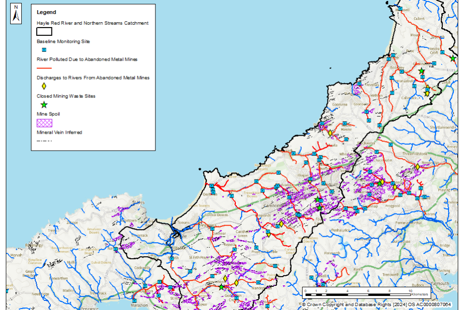
© Environment Agency
It should be noted that due to close proximity of some of the sampling points to each other, some of the sampling point markers on this map (blue squares) may overlap.
Penwith Peninsula operational catchment: baseline polluted rivers
The Marazion (also known as “Red”) River is polluted by copper, zinc, and cadmium below the confluence of the Tregilliowe Stream, which is also highly polluted by copper, zinc and cadmium.
Figure 6 shows the baseline polluted rivers in this operational catchment.
Figure 6. The baseline length of rivers polluted by target substances from abandoned metal mines in the Penwith Peninsula operational catchment is 11km
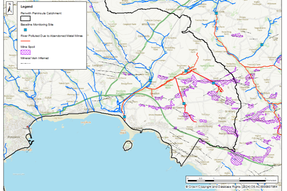
© Environment Agency
It should be noted that due to close proximity of some of the sampling points to each other, some of the sampling point markers on this map (blue squares) may overlap.
Cober and Lizard operational catchment: baseline polluted rivers
In the Upper River Cober catchment, the Medlyn Stream is polluted by copper, zinc and cadmium. Below the confluence with the Medlyn Stream, the River Cober is also polluted by copper for a short distance, as shown by data collected at the monitoring site at Trenear Bridge.
The Lower River Cober is polluted by zinc in all stretches below the confluence of the Mellangoose Stream. The Mellangoose Stream is polluted by copper, zinc and cadmium throughout.
The Porthleven Stream is polluted by copper, nickel, zinc and cadmium throughout the catchment, with the stream failing right up to its headwaters. However, the tributary of the Porthleven Stream at Tregew Farm is not polluted.
Figure 7 shows the baseline polluted rivers in this operational catchment.
Figure 7. The baseline length of rivers polluted by target substances from abandoned metal mines in the Cober and Lizard operational catchment is 22km
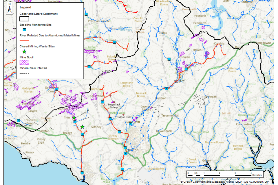
© Environment Agency
It should be noted that due to close proximity of some of the sampling points to each other, some of the sampling point markers on this map (blue squares) may overlap.