Aire and Calder abstraction licensing strategy
Updated 16 January 2025
Applies to England
1. About the licensing strategy
This strategy sets out our approach to managing new and existing abstraction and impoundment within the Aire and Calder catchment in the Humber river basin district.
Our approach ensures that we:
- meet river basin management plan objectives for water resources activities
- avoid deterioration within this catchment
We apply this approach to the water body in which the abstraction is located.
It also applies to:
- all downstream surface water bodies that may be affected by any reduction in abstraction-related flow
- adjacent groundwater bodies affected by any reduction in groundwater level
Our guidance on managing water abstraction gives the technical explanation, legal and policy requirements behind the abstraction licensing strategy (ALS).
Please see our guidance if you need to:
- check if you need a licence to abstract water
- check if you need a licence to impound water
- apply for an abstraction or impounding licence
While our assessment tools are continuously updated, we aim to update this document every 3 years. Because of this some details in this document, for example hands off flow (HoF) values, may be out of date. You can contact the Environment Agency for the latest data.
1.1 Collaborative and sustainable water management
Our long-term goal is to develop a stronger catchment focus for water resources. We are working with abstractors and catchment groups to:
- develop local solutions to existing pressures
- prepare for the future
Catchment groups may include a variety of different partnership groups such as:
- abstractor groups
- local catchment partnerships
- priority catchment groups
- environmental groups
Since the autumn of 2018, we have been collaborating with local partners. In several priority catchments across England we have explored:
- modern and innovative ways of improving access to water
- alternative ways to achieving sustainable abstraction
This strategy is a tool to make informed decisions on the choices abstractors make about their use of water. We want this strategy to help abstractors plan their water use and become more resilient in the face of climate change.
2. Catchment overview
The Aire and Calder catchment is situated in West Yorkshire and encompasses an area of approximately 2,057km2. The catchment stretches from Malham and Todmorden in the West to the River Ouse in the East. Significant towns and cities located wholly or partially within the boundaries of this ALS area include:
- Bradford
- Leeds
- Halifax
- Wakefield
- Castleford
- Huddersfield
There’s more information about the Aire and Calder ALS area on the catchment data explorer.
2.1 Landscape and land use
Land use in the upper Aire and Calder is centred on dairy cattle and sheep farming. The drier and freely draining areas in the lower Aire and Calder can support arable and root crops. In the urban areas of the towns and cities listed above land is mostly used for housing. There are also several protected areas within the catchment highlighting the diverse nature of the environment.
Aire and Calder landscape and land use summary statistics
Population: 2,332,469 (estimated from ONS 2020 mid-year local authority estimates).
1,864 farms covering 92,830 hectares of farmland (Defra farm statistics).
2.2 Water resources
The River Aire rises high in the Pennine Hills near Malham in the Yorkshire Dales National Park. It flows in a south easterly direction through limestone moorland areas passing:
- Keighley
- Bingley
- Bradford
- Leeds
- Castleford
At Castleford, the river turns eastwards to Goole where it meets the River Ouse, 148km from its source at Malham. From Keighley to Goole, the river flows through populated and industrialised areas.
The River Calder rises on the Pennine Moors west of Todmorden. It is predominately an urban river flowing through the West Yorkshire settlements of:
- Halifax
- Brighouse
- Huddersfield
- Dewsbury
- Wakefield
The River Calder then joins the River Aire at Castleford, 87km from its source.
There is an extensive canal network in the Aire and Calder catchment that includes the Leeds Liverpool Canal. The canal follows the River Aire closely through Skipton and Shipley, then down to Leeds where it joins the Aire and Calder Navigation.
The Selby Canal forms an artificial link between the River Aire at West Haddlesey and the River Ouse at Selby.
In the Calder catchment the Rochdale Canal runs from the heart of Manchester to its junction with the Calder and Hebble Navigation at Sowerby Bridge.
The Huddersfield Narrow Canal runs from the centre of Huddersfield to its junction with the Ashton Canal in Ashton-under-Lyne. This roughly follows the River Colne and the River Tame.
The Huddersfield Broad Canal runs between the Huddersfield Narrow Canal in the centre of Huddersfield to the Calder and Hebble Navigation at Cooper Bridge.
The majority of the Aire and Calder ALS area is underlain by Millstone Grit and Coal Measures. To the east of the catchment these are overlain by a thin band of Magnesian Limestone and Sherwood Sandstone. The Sherwood Sandstone provides one of the major groundwater sources for Yorkshire’s public water supply. The upper headwaters of the Aire are underlain by Carboniferous Limestone, forming the source of the river and is the oldest rock in the area.
The active water company in the Aire and Calder is Yorkshire Water. The catchment contains over 50 reservoirs licensed to provide water for public supply. The reservoirs in the Pennine uplands at the head of the valley also play a vital role in maintaining a healthy river flow. There are several sewage treatment works in the Aire and Calder catchment, which discharge a large quantity of water into both rivers.
There are many (both surface and groundwater) abstraction licences within the ALS area. These take water from the rivers, reservoirs and groundwater sources within the catchment for use by people and industries.
Most of the water used in this catchment is for:
- public water supply
- the chemical industry
- textiles
- mineral washing
- fish farming
The highest non-consumptive use of water in the area is for hydropower and power generation. The canals, rivers and reservoirs are also used for a variety of recreation and leisure activities including pleasure boating and canoeing.
2.3 Climate change
Climate change will likely impact on the quantity and seasonal availability of water resources within the Aire and Calder catchment.
2.4 Partnership working
The Aire and Calder Catchment Partnership is active in this catchment which brings together stakeholders from a range of backgrounds. It aims to develop collaborative approaches to water resources management and planning as well as address issues in the catchment.
The Aire Rivers Trust partnership website has more information on:
- ongoing activities in the Aire and Calder catchment
- how you can get involved
3. Water resource availability in the Aire and Calder catchment
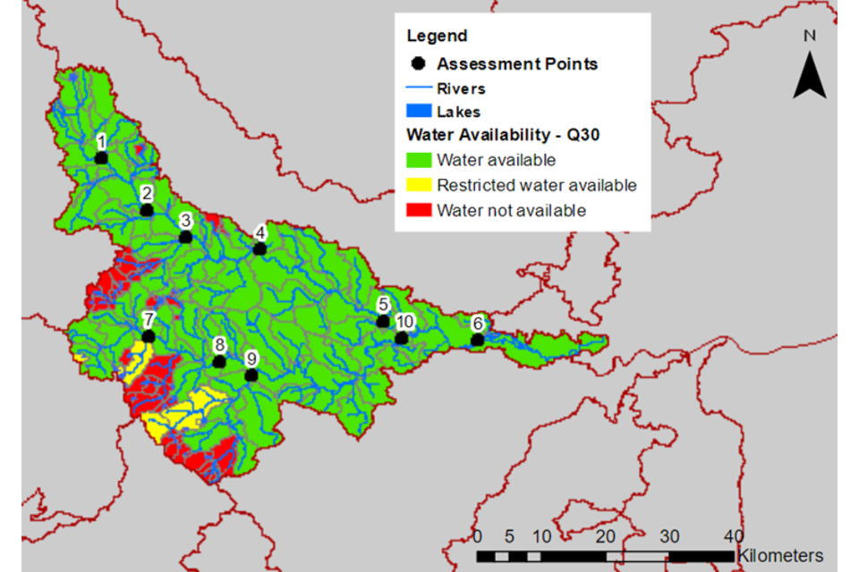
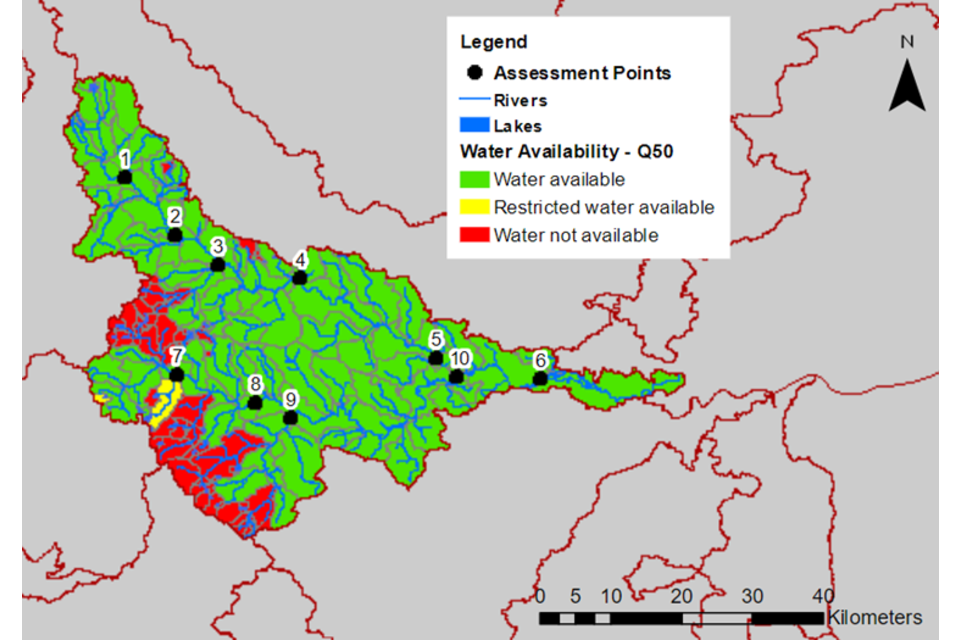
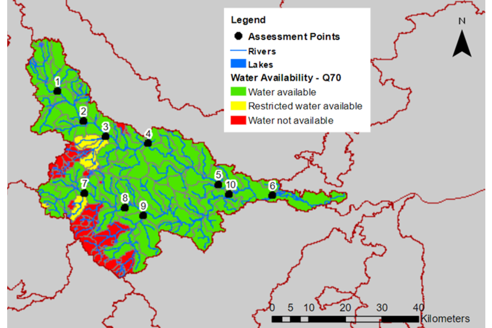
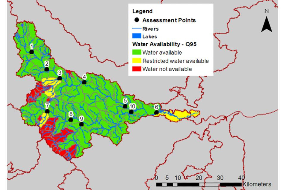
The method for calculating the water resource availability is explained in our guidance on managing water abstraction. Water availability is calculated at selected assessment points (APs). The maps show the water availability calculated at the AP – local water availability may differ.
There are 10 APs in the Aire and Calder ALS:
- AP1 covers the Aire headwaters and feeding tributaries from Malham Tarn to Gargrave gauging station
- AP2 covers the River Aire downstream of Gargrave gauging station to Kildwick gauging station and the tributary Eshton Beck
- AP3 covers the River Worth and tributaries
- AP4 covers the River Aire downstream of Kildwick gauging station to just upstream of the confluence with Gill Beck (Guisley) and tributaries including Bradford Beck
- AP5 covers the River Aire from just upstream of the confluence with Gill Beck (Guisley) to Oulton Lemonroyd gauging station and tributaries
- AP6 covers the River Aire from Oulton lemonroyd gauging station to Beal gauging station and tributaries including Oulton Beck
- AP7 covers the River Calder from source to just upstream of the confluence with Cragg Brook at Mytholmroyd and tributaries including:
- Walsden Water
- Hebden Water
- Colden Water
- AP8 covers the River Calder from just upstream of the confluence with Cragg Brook at Mytholmroyd to Elland gauging station and tributaries including:
- River Ryburn
- Leddenden Brook
- Cragg Brook
- Hebble Brook
- Black Brook
- AP9 covers the River Colne from source to Colne Bridge gauging station and tributaries the River Holme and Fenay Beck
- AP10 covers the River Calder from Elland gauging station to Methley gauging station and tributaries
3.1 Water resource availability colours and implications for licensing
We use colours to represent different surface water availability at a range of flows.
High hydrological regime
Blue

There is more water than required to meet the needs of the environment. However, due to the need to maintain the near pristine nature of the water body, further abstraction is severely restricted.
Water available for licensing
Green

There is more water than required to meet the needs of the environment. New licences can be considered depending on local and downstream impacts.
Restricted water available for licensing
Yellow

Full licensed flows fall below the environmental flow indicators (EFI).
If all licensed water is abstracted there will not be enough water left for the needs of the environment. No new consumptive licences would be granted. It is likely we’ll be taking action to reduce full licensed risks. Water may be available if you can ‘buy’ (known as licence trading) the entitlement to abstract water from an existing licence holder.
Water not available for licensing
Red

Recent actual flows are below the EFI.
This scenario highlights water bodies where flows are below the indicative flow requirement to help support a healthy ecology in our rivers. We call this ‘good ecological status’ (GES) or ‘good ecological potential’ (GEP) where a water body is heavily modified for reasons other than water resources.
We are currently taking action in water bodies that are not supporting GES or GEP. We will not grant further licences. Water may be available if you can buy (known as licence trading) the amount equivalent to recently abstracted from an existing licence holder.
Heavily modified water bodies (and discharge rich water bodies)
Grey

These water bodies have a modified flow that is influenced by reservoir compensation releases, or they have flows that are augmented. These are often known as ‘regulated rivers’. They may be managed through an operating agreement, often held by a water company. The availability of water is dependent on these operating agreements. More detail if applicable can be found in section 4.1.
There may be water available for abstraction in discharge rich catchments. You need to contact the Environment Agency to find out more.
The water resource availability is calculated, and the colour assigned, at 4 different flows:
- Q30 – the flow of a river which is exceeded on average for 30% of the time – therefore you would expect the river flow to be lower than Q30 on 256 days in an average year, that is, a higher flow
- Q50 – the flow of a river which is exceeded on average 50% of the time – therefore you would expect the river flow to be lower than Q50 on 183 days in an average year
- Q70 – the flow of a river which is exceeded on average for 70% of the time – therefore you would expect the river flow to be lower than Q70 on 110 days in an average year
- Q95 – the flow of a river which is exceeded on average for 95% of the time – therefore you would expect the river flow to be lower than Q95 on 18 days in an average year, that is, a low flow
3.2 Water availability maps
The water availability colours for the Aire and Calder catchment are presented in Table 1 and maps 1 to 4.
Table 1: summary of maps 1 to 4 – water availability at each assessment point by flow category
| Assessment point and name | Q30 | Q50 | Q70 | Q95 |
|---|---|---|---|---|
| 1 Aire Headwaters | Water available | Water available | Water available | Water available |
| 2 Upper Aire | Water available | Water available | Water available | Water available |
| 3 River Worth | Water available | Water available | Water available | Restricted water available |
| 4 Upper Mid Aire | Water available | Water available | Water available | Water available |
| 5 Lower Mid Aire | Water available | Water available | Water available | Water available |
| 6 Lower Aire | Water available | Water available | Water available | Restricted water available |
| 7 Upper Calder | Restricted water available | Restricted water available | Restricted water available | Restricted water available |
| 8 Mid Calder | Water available | Water available | Water available | Water available |
| 9 River Colne | Restricted water available | Water not available | Water not available | Water not available |
| 10 Lower Calder | Water available | Water available | Water available | Water available |
Map 1: water resource availability colours at Q30 for the Aire and Calder ALS
© Environment Agency copyright and database right 2023. All rights reserved. This map includes data supplied under licence from: © Crown Copyright and database right 2023. All rights reserved. Ordnance Survey licence number 100024198.
Map 2: water resource availability colours at Q50 for the Aire and Calder ALS
© Environment Agency copyright and database right 2023. All rights reserved. This map includes data supplied under licence from: © Crown Copyright and database right 2023. All rights reserved. Ordnance Survey licence number 100024198.
Map 3: water resource availability colours at Q70 for the Aire and Calder ALS
© Environment Agency copyright and database right 2023. All rights reserved. This map includes data supplied under licence from: © Crown Copyright and database right 2023. All rights reserved. Ordnance Survey licence number 100024198.
Map 4: water resource availability colours at Q95 for the Aire and Calder ALS
© Environment Agency copyright and database right 2023. All rights reserved. This map includes data supplied under licence from: © Crown Copyright and database right 2023. All rights reserved. Ordnance Survey licence number 100024198.
3.3 Groundwater resource availability
Abstracting groundwater can impact on overlying surface water bodies. This impact is measured at the surface water AP. We cannot grant new groundwater licences where abstraction is reducing flows to below the indicative flow requirement to help support a healthy ecology. This is based on Q95 flows.
We must also account for the:
- available resource in the aquifer
- impact of abstraction on protected sites
- risk of saline intrusion
3.4 Groundwater resource availability colours and implications for licensing
We use colours to represent different groundwater availability.
Water available for licensing
Green

Groundwater unit balance shows groundwater available for licensing. New licences can be considered depending on impacts on other abstractors, designated ecological sites and on surface water.
Restricted water available for licensing
Yellow

Groundwater unit balance shows more water is licensed than the amount available. But the actual situation is sustainable because either:
- recent actual abstractions are lower than the amount available
- management options are in place to deal with the known impacts
In restricted groundwater units no new consumptive licences will be granted. We may also investigate the possibilities for reducing fully licensed risks. Water may be available if you can ‘buy’ (known as licence trading) the entitlement to abstract water from an existing licence holder.
In other units there may be restrictions in some areas, for example in relation to saline intrusion.
Water not available for licensing
Red

Groundwater unit balance shows more water has been abstracted based on recent amounts than the amount available.
We will not grant further licences.
3.5 Groundwater availability map
Map 5: groundwater availability in the Aire and Calder ALS area
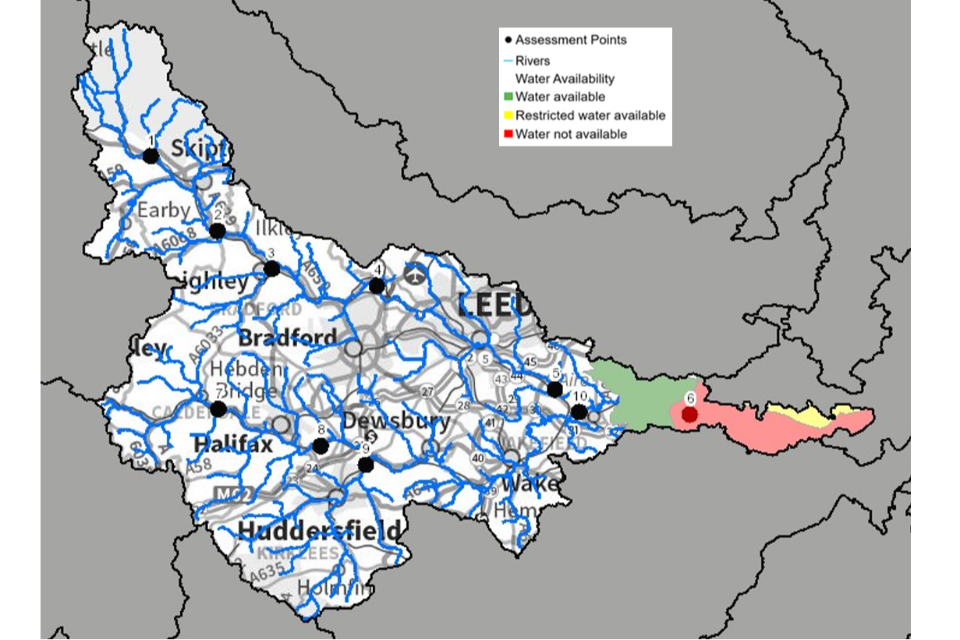
© Environment Agency copyright and database right 2023. All rights reserved. This map includes data supplied under licence from: © Crown Copyright and database right 2023. All rights reserved. Ordnance Survey licence number 100024198.
3.6 Resource reliability
If you want to apply for a licence, it’s worth considering the reliability of your abstraction. By assessing the quantity of water available at different flows it’s possible to see:
- when there is a surplus or deficit of water
- the associated reliability of an abstraction
This is an indication only. Actual reliability of a licence will be discussed when you apply.
Below is an indication of the resource availability for consumptive abstraction in the Aire and Calder ALS area expressed as a percentage of time:
- AP1: Consumptive abstraction is available at least 95% of the time
- AP2: Consumptive abstraction is available at least 95% of the time
- AP3: Consumptive abstraction is available less than 30% of the time
- AP4: Consumptive abstraction is available at least 95% of the time
- AP5: Consumptive abstraction is available at least 95% of the time (except from Milshaw Beck where consumptive abstraction is available at least 70% of the time)
- AP6: Consumptive abstraction is available at least 95% of the time
- AP7: Consumptive abstraction is available at least 95% of the time
- AP8: Consumptive abstraction is available at least 95% of the time
- AP9: Consumptive abstraction is available less than 30% of the time
- AP10: Consumptive abstraction is available at least 95% of the time
3.7 Other considerations for resource availability and reliability
We may have to add constraints to licences such as ‘hands off flow’ (HoF) or ‘hands off level’ (HoL) conditions to protect the environment and the rights of other abstractors. As a result, when we grant a licence, it does not mean that we guarantee a supply of water. These conditions specify that if the flow in the river drops below what is needed to protect the environment, abstraction must reduce or stop. So, in dry years, restrictions are likely to apply more often, which will affect the reliability of supply.
Whilst this document may say that water is available for abstraction, this does not guarantee that all applications will be successful. This is because we must determine each application on its own merits, and local factors may mean we are either unable to grant a licence as applied for, or even at all.
New licences within an ALS are usually given a common end date (CED), which allows them to be reviewed at the same time.
The next CED for this ALS is 31 March 2027 and the subsequent one is 31 March 2039.
Map 6: water resource reliability in the Aire and Calder catchment expressed as percentage of time available
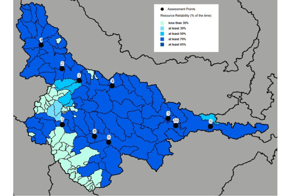
© Environment Agency copyright and database right 2023. All rights reserved. This map includes data supplied under licence from: © Crown Copyright and database right 2023. All rights reserved. Ordnance Survey licence number 100024198.
3.8 Impoundments
Applications for impoundments are dealt with on a case-by-case basis. There’s more information in our guidance on how to check if you need a licence to impound water.
4. How we manage water availability in the Aire and Calder ALS
4.1 Surface water
We assess surface water flows at assessment points (APs), which are significant points on a river, often where 2 major rivers join or at a gauging station. APs cover multiple surface water bodies.
Table 2 gives an indication of:
- how much water is available for further abstraction
- the associated restrictions we may have to apply to new and varied abstraction licences from the main river
Depending on the nature of the catchment, tributaries to the main river may be subject to different restrictions and quantities. This may be assessed locally on a case-by-case basis.
Each HoF is linked to an AP and is dependent on the resource availability at that AP. In some cases, additional restrictions may apply to licences where there is a more critical AP resource availability downstream. This protects the ecological requirements of the river and other water users. This is detailed in the last column of Table 2 if applicable.
All abstraction licence applications are subject to an assessment. This takes account of any local and downstream issues. It may be subject to further restrictions.
Reading from top to bottom in Table 2 are the APs in the Aire and Calder ALS area. Reading across the columns you can see the:
- potential HoF that may be applied to a licence
- number of days water may be available under this restriction
- approximate volume of water in Ml/d that may be available
In cases where there is water available at all flow, we may apply a minimum residual flow (MRF) to protect very low flows. We will decide this on a case-by-case basis. In the Aire and Calder catchment hydropower derogation agreements may have an impact on the restrictions required. We recommend that you contact the area team for more information on this.
Table 2: summary of licensing approach for the assessment points of Aire and Calder ALS
| AP and name | AP National Grid Reference | Water resource availability | HoF restriction (Ml/d) | Number of days per annum abstraction may be available | Approximate volume available at restriction (Ml/d) | Is there a gauging station at this AP? |
|---|---|---|---|---|---|---|
| 1 Aire Headwaters | SD 93737 53939 | Water available for licensing | Contact area | 361 | 0.4 | Yes |
| 2 Upper Aire | SE 01071 45692 | Water available for licensing | Contact area | 361 | 11.6 | Yes |
| 3 River Worth | SE 07062 41500 | Water available for licensing | Contact area | 127 | 17.4 | Yes |
| 4 Upper Mid Aire | SE 18607 39642 | Water available for licensing | Contact area | 361 | 55.8 | No |
| 5 Lower Mid Aire | SE 38169 28214 | Water available for licensing | Contact area | 361 | 314.7 | Yes |
| 6 Lower Aire | SE 52999 25452 | Water available for licensing | Contact area | 361 | 241.5 | Yes |
| 7 Upper Calder | SE 01159 26054 | Water available for licensing | Contact area | 361 | 16.1 | Yes |
| 8 Mid Calder | SE 12407 21990 | Water available for licensing | Contact area | 361 | 43.8 | Yes |
| 9 River Colne | SE 17390 19915 | Restricted water available | Contact area | 127 | 102.7 | Yes |
| 10 Lower Calder | SE 40845 25732 | Water available for licensing | Contact area | 361 | 53.5 | Yes |
4.2 Groundwater
For principal aquifers we may divide the area into groundwater management units (GWMU), which are sub-divisions of the groundwater bodies. In these cases, we use the information and assessments on these units to determine water availability and licence restrictions.
Where groundwater abstractions directly impact on surface water flows the impact is measured at the surface water AP. This includes where the impact reduces baseflow. In these cases, restrictions may be applied to licences, such as HoL conditions. The HoL is a groundwater level below which an abstractor is required to reduce or stop abstraction. Where there is known connectivity between surface water and groundwater, we may apply a HoF condition to the groundwater licence. This will relate to an appropriate surface water gauge.
Other restrictions may apply where availability is limited or to protect the environment, for example to prevent saline intrusion.
4.3 Licence restrictions on groundwater abstractions in the Aire and Calder ALS area
Aire and Calder Magnesian Limestone GWMU
The Magnesian Limestone aquifer overlies the Coal Measures and occurs immediately to the east of the Coal Measures in the Castleford area. Extensive faulting and fissuring of the limestone results in the aquifer being vulnerable to pollution. A long history of quarrying the limestone increases the risk because of the reduction in thickness of the unsaturated zone and removal of overburden.
Where superficial drift cover is absent, groundwater can be hydraulically connected to surface waters. In these cases, the same resource availability may apply to both surface and groundwater. However, the River Aire is underlain by thick superficial drift deposits. It is unlikely to interact to any great extent with groundwater from the Aire and Calder Magnesian Limestone GWMU. River flows are likely to be less sensitive to groundwater abstraction from this GWMU. Groundwater from this GWMU is available for licensing on a case-by-case basis (subject to assessment of local conditions and dependent on the outcome of groundwater pumping tests).
Aire and Calder Sherwood Sandstone GWMU
The Sherwood Sandstone aquifer provides one of the major groundwater resources for Yorkshire. It has been extensively developed for abstraction for public water supply between Selby and Doncaster. The agricultural and industrial sectors also utilise the Sherwood Sandstone in this area for abstraction.
Natural groundwater flow within the Sherwood Sandstone is generally eastwards. Most of the outcrop area is low-lying, resulting in low hydraulic gradients within the aquifer. Between the 1970s and mid 1990s there was an observed general decline in the groundwater level across the aquifer. This is because abstraction activity increased during this period. Our groundwater level information suggests that the level has remained relatively stable during recent years away from the concentrated areas of groundwater abstraction. However, it is still below sea level in some areas which we consider to be an unnatural situation.
Map 7 shows the Selby Sherwood Sandstone aquifer area which covers the following ALS areas:
- Derwent
- Wharfe and Lower Ouse
- Aire and Calder
- Don and Rother
- Hull and East Riding
The line plotted on the map represents where the general groundwater level within the Selby Sherwood Sandstone aquifer that is approximate to sea level. To the north of this line the groundwater level is considered to be above sea level. To the south of the line groundwater level is considered to be below sea level. However, we may use site specific groundwater level information to determine this and therefore how we would licence groundwater at such a location.
The Aire and Calder Sherwood Sandstone GWMU is located to the south of the general groundwater line that is approximate to sea level. There is a risk that proposals for new abstraction could further draw down the groundwater level in this GWMU. This may lead to the ingress of poorer quality water entering the freshwater zone of the aquifer. We do not consider this to be acceptable because it may compromise our duties towards protecting and improving the quality and quantity of our groundwater. Therefore, the moratorium imposed on issuing new abstraction licences is still in place within the Aire and Calder Sherwood Sandstone GWMU.
If the Aire and Calder Sherwood Sandstone GWMU defined as restricted water available, we may consider licence trading within this GWMU where:
- there is no net increase in fully licensed abstraction
- it is demonstrated that there is no overall detrimental impact to the aquifer
If the Aire and Calder Sherwood Sandstone GWMU defined as water not available, we may consider licence trading within this GWMU where:
- there is no net increase in actual abstraction
- it is demonstrated that there is no overall detrimental impact to the aquifer
Licence trades will be subject to assessment of local conditions and dependent on the outcome of groundwater pumping tests.
Secondary and unproductive aquifers
Much of the Aire and Calder catchment is underlain by secondary or unproductive aquifers which are not managed as GWMUs. These aquifers from north-west to south-east of the catchment are:
- the Carboniferous Limestone
- the Millstone Grit
- the Coal Measures
- other superficial (unconsolidated) deposits
The geological properties of these aquifers can vary greatly even over a short distance. This makes them potential sources of water supply at a local rather than strategic scale. The effects of historic mining activities can result in complex groundwater flow regimes and levels, further complicating assessment. This means that any proposal to abstract groundwater from one of these aquifers will require case-by-case assessment. Assessments will help understand:
- how sustainable the abstraction will be
- The impact of the abstraction on surface water features and other lawful users of water
Restrictions, as outlined above, will be applied as necessary.
Map 7: the Sherwood Sandstone aquifer
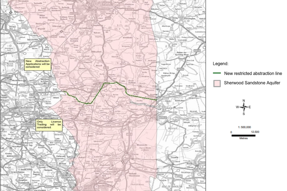
© Environment Agency copyright and database right 2023. All rights reserved. This map includes data supplied under licence from: © Crown Copyright and database right 2023. All rights reserved. Ordnance Survey licence number 100024198.
4.4 Coasts and estuaries
The Beal River flow gauging station measures the freshwater flow from the Aire and Calder catchment into the Humber Estuary. This accounts for only about 15% of the total freshwater inflow to the Humber.
Tidal effects are only seen at Beal in exceptional circumstances. The substantial weir at Haddlesey 6km downstream is the normal tidal limit. The maximum value recorded at the level gauge just downstream of the weir is just over 5.2 metres above ordinance datum (mAOD). This level occurs once every 15 months. Above this level, the washlands downstream start to fill. Abstraction from tidal reaches makes up less than 1% of the total volume abstracted in the Aire and Calder ALS area. Licence applications in tidal and estuarine areas will be considered on a case-by-case basis.
4.5 Heavily modified water bodies
Many surface water bodies are designated as ‘heavily modified’ for water resource purposes in the Aire and Calder catchment. They contain a public water supply reservoir or the flow regime is substantially modified due to reservoir compensation releases.
The watercourses in the west of the catchment are dominated by impounding reservoirs operated by Yorkshire Water Services Ltd for public water supply. Many of these impoundments discharge compensation water, which makes up the base flow in some headwaters. These discharges, along with effluent discharges from industry and sewage treatment works, may form a significant proportion of the flow during dry periods. In dry summer weather, about 65% of the river flow below Leeds is effluent, much of which is derived from outside the catchment. This has the impact of keeping the lowest flows at a relatively consistent level year-on-year but poses challenges for pollution control.
The reservoirs in the Aire and Calder catchment are listed below, whether they issue compensation water and which APs are impacted by this artificial modification.
The compensation releases listed have been modelled in the CAMS process.
| Reservoir | Compensates or storage | AP impacted |
|---|---|---|
| Winterburn | Compensates | AP1 – Aire Headwaters |
| Elslack | Compensates and storage | AP2 – Upper Aire |
| Embsay | Compensates and storage | AP2 – Upper Aire |
| Whinney Gill | Storage | AP2 – Upper Aire |
| Silsden | Compensates | AP2 – Upper Aire |
| Keighley Moor | Compensates and storage | AP3 – River Worth |
| Watersheddles | Storage | AP3 – River Worth |
| Ponden | Compensates and storage | AP3 – River Worth |
| Lower Laithe | Storage | AP3 – River Worth |
| Leeshaw | Compensates | AP3 – River Worth |
| Leeming | Compensates | AP3 – River Worth |
| Thornton Moor | Storage | AP4 – Upper Mid Aire |
| Stubden | Storage | AP4 – Upper Mid Aire |
| Doe Park | Compensates | AP4 – Upper Mid Aire |
| Hewenden | Compensates | AP4 – Upper Mid Aire |
| Graincliffe | Storage | AP4 – Upper Mid Aire |
| Eldwick | Compensates | AP4 – Upper Mid Aire |
| Weecher | Compensates and storage | AP4 – Upper Mid Aire |
| Reva | Compensates and storage | AP4 – Upper Mid Aire |
| Gorpley | Compensates | AP7 – Upper Calder |
| Gorple Upper | Storage | AP7 – Upper Calder |
| Gorple Lower | Storage | AP7 – Upper Calder |
| Widdop | Storage | AP7 – Upper Calder |
| Walshaw Dean Upper | Storage | AP7 – Upper Calder |
| Walshaw Dean Middle | Storage | AP7 – Upper Calder |
| Walshaw Dean Lower | Storage | AP7 – Upper Calder |
| Warley Moor | Storage | AP8 – Mid Calder |
| Dean Head Upper | Storage | AP8 – Mid Calder |
| Dean Head Lower | Storage | AP8 – Mid Calder |
| Castle Carr | Compensates | AP8 – Mid Calder |
| Ogden | Compensates and storage | AP8 – Mid Calder |
| Mixenden | Storage | AP8 – Mid Calder |
| Withens Clough | Compensates and storage | AP8 – Mid Calder |
| Turvin Clough | Compensates and storage | AP8 – Mid Calder |
| Baitings | Compensates and storage | AP8 – Mid Calder |
| Ryburn | Compensates and storage | AP8 – Mid Calder |
| Green Withens | Storage | AP8 – Mid Calder |
| Booth Dean Upper | Storage | AP8 – Mid Calder |
| Booth Dean Lower | Storage | AP8 – Mid Calder |
| Boothwood | Compensates and storage | AP8 – Mid Calder |
| Ringstone | Compensates and storage | AP8 – Mid Calder |
| Deanhead | Storage | AP8 – Mid Calder |
| Scammonden | Compensates and storage | AP8 – Mid Calder |
| Wessenden Head | Storage | AP9 – River Colne |
| Wessenden Old | Storage | AP9 – River Colne |
| Blakeley | Storage | AP9 – River Colne |
| Butterley | Compensates and storage | AP9 – River Colne |
| Deerhill | Compensates and storage | AP9 – River Colne |
| Blackmoorfoot | Compensates and storage | AP9 – River Colne |
| Bilberry | Storage | AP9 – River Colne |
| Digley | Compensates and storage | AP9 – River Colne |
| Yateholme | Storage | AP9 – River Colne |
| Riding Wood | Storage | AP9 – River Colne |
| Ramsden | Compensates and storage | AP9 – River Colne |
| Brownhill | Compensates and storage | AP9 – River Colne |
| Holmestyes | Compensates | AP9 – River Colne |
| Boshaw Whams | Compensates | AP9 – River Colne |
4.6 Protected sites
The Conservation of Habitats and Species Regulations 2017 (Habitats Regulations) provides a very high level of protection to:
- special areas of conservation (SAC), which contribute to biodiversity by maintaining and restoring habitats and species
- special protection area (SPA), which provides protection to birds and their nests, eggs and habitats
Government policy treats Ramsar sites (internationally important wetland sites) in the same way as SACs and SPAs. Ramsars, SACs and SPAs are referred to collectively as European sites. Sites of special scientific interest (SSSI) also carry a high level of environmental importance.
Conservation objectives are the main objectives for European and SSSI protected sites to maintain at, or to reach, favourable condition. These are set by Natural England. The process for setting targets is described through the Joint Nature Conservation Committee approved ‘Common Standards Monitoring guidance’. Natural England use these targets to assess the condition of European and SSSI protected sites. These quantitative targets are considered by Natural England as a pre-requisite for achieving the conservation objectives for European or SSSI designated sites. We have a duty to have regard to Natural England’s advice when determining licence applications that may impact on a designated site.
We may need more detailed supporting information when a licence application could impact on a designated conservation site. This will allow us to complete the required statutory assessment.
Water related SSSIs:
- Malham-Arncliffe
- New House Meadows
- Pikedaw Calamine Caverns
- West Nidderdale, Barden and Blubberhouses Moors
- Stonehead Beck (Gill Beck)
- Trench Meadows
- Bingley South Bog
- South Pennine Moors
- Leeds-Liverpool Canal
- Crimsworth Dean
- Broadhead Clough
- Withens Clough
- Denby Grange Colliery Ponds
- Seckar Wood
- Fairburn and Newton Ings
- Mickletown Ings
- Townclose Hills
- Roach Lime Hills
- Eskamhorn Meadows
- Breary Marsh
Water related SACs:
- Denby Grange Colliery Ponds
- Craven Limestone Complex
- North Pennine Dales Meadows
- North Pennine Moors
- South Pennine Moors
Water related SPAs:
- North Pennine Moors
- South Pennine Moors
5. Managing the catchment together
5.1 Action on unsustainable abstraction
Our guidance on managing water abstraction gives details on:
- what an unsustainable abstraction is
- the measures available to resolve environmental issues caused by abstraction
There are a series of actions that we are taking to address unsustainable abstraction, as part of our water abstraction plan. These include:
- taking action to reduce or revoke any unused or partially used licences across the area to secure the proper use of water resources
- reviewing time limited licences, adjusting them as necessary to make sure they do not allow environmental damage now and in the future
5.2 Water rights trading
We want to make it easier to trade water rights. A water rights trade is where a person sells all or part of their water right, as defined by their abstraction licences, to another person on a permanent or temporary basis. In many cases a trade will involve a change in abstraction location and use which we will need to approve through the issue or variation of abstraction licences.
In licensing trades, as with new abstraction licences, we need to make sure that we do not cause any deterioration in water body status both within the water bodies where the trade will take place and to downstream water bodies. Section 5.3 provides a guide to the potential for trading in water bodies of a particular ALS water resource availability colour, as shown on maps 1 to 4.
To find out more about licence trading, use our guidance on trading water abstraction rights.
5.3 Guide to potential trading based on water resource availability colours
High hydrological regime
Blue

Opportunities for trading water rights will be limited.
Water available for licensing
Green

There may be opportunities to allow trades of recent actual abstraction and licensed abstraction. But little demand for trading is expected as water is available for new abstractions.
Restricted water available for licensing
Yellow

There may be opportunities for licence holders to trade up to their full licensed quantities. But the quantities of water available to trade may be restricted once levels of actual abstraction reach sustainable limits. We will not permit licence trades in water bodies where we are taking action to prevent deterioration. The exception to this is if the trade is consistent with achieving water body objectives.
Water not available for licensing
Red

We will only trade recent actual abstraction but no increase in recent actual abstraction is permitted in the water body. Licensed abstraction will be recovered for the environment.
Heavily modified water bodies
Grey

Opportunities for trading will depend on local operating agreements and local management.
To find out more about licence trading, use our guidance on trading water abstraction rights.
6. Glossary
Abstraction: Removal of water from a source of supply (surface or groundwater).
Abstraction licence: The authorisation granted by the Environment Agency to allow the removal of water.
Assessment point: A significant point on a river, often where 2 major rivers join or at a gauging station.
Catchment: The area from which precipitation and groundwater will collect and contribute to the flow of a specific river.
Consumptive abstraction: Abstraction where a significant proportion of the water is not returned to the source of supply after use. For example, for the use of spray irrigation, general agriculture, domestic use, public water supply and water bottling.
Discharge: The release of substances (for example, water, treated sewage effluent) into surface waters.
Environmental flow indicator: Flow indicator to prevent environmental deterioration of rivers, set in line with new UK standards set by UKTAG.
Groundwater: Water that is contained in underground rocks.
Hands off flow: A condition attached to an abstraction licence which states that if flow (in the river) falls below the level specified on the licence, the abstractor will be required to reduce or stop the abstraction.
Hands off level: A condition attached to an abstraction licence which states that if level (in the river or groundwater aquifer) falls below the level specified on the licence, the abstractor will be required to reduce or stop the abstraction.
Impoundment: A structure that obstructs or impedes the flow of inland water, such as a dam, weir or other constructed works.
Non consumptive abstraction: Abstraction where a significant proportion of the water is returned either directly or indirectly to the source of supply after use. For example, for hydropower.
Surface water: This is a general term used to describe all water features such as rivers, streams, springs, ponds and lakes.
Water body: Units of either surface water or groundwater which we use to assess water availability.

