Developing estates: plan requirements and surveying specification (Practice Guide 41, supplement 5)
Updated 25 June 2015
Applies to England and Wales
Please note that HM Land Registry’s practice guides are aimed primarily at solicitors and other conveyancers. They often deal with complex matters and use legal terms.
To view the update history for this practice guide, please see practice guide 41, supplement 5: update history.
1. Overview
This supplement provides information and advice relating to the technical specification of any plan lodged with HM Land Registry for the purposes of:
- estate boundary approval.
- estate plan approval
To meet the developer’s and HM Land Registry’s requirements it is important that the plans you lodge satisfy all the criteria outlined in this supplement. HM Land Registry is always happy to consider any special circumstances that might apply to a particular development and discuss the best way forward.
2. Plan specification
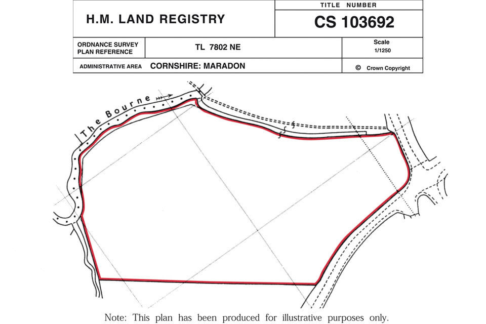
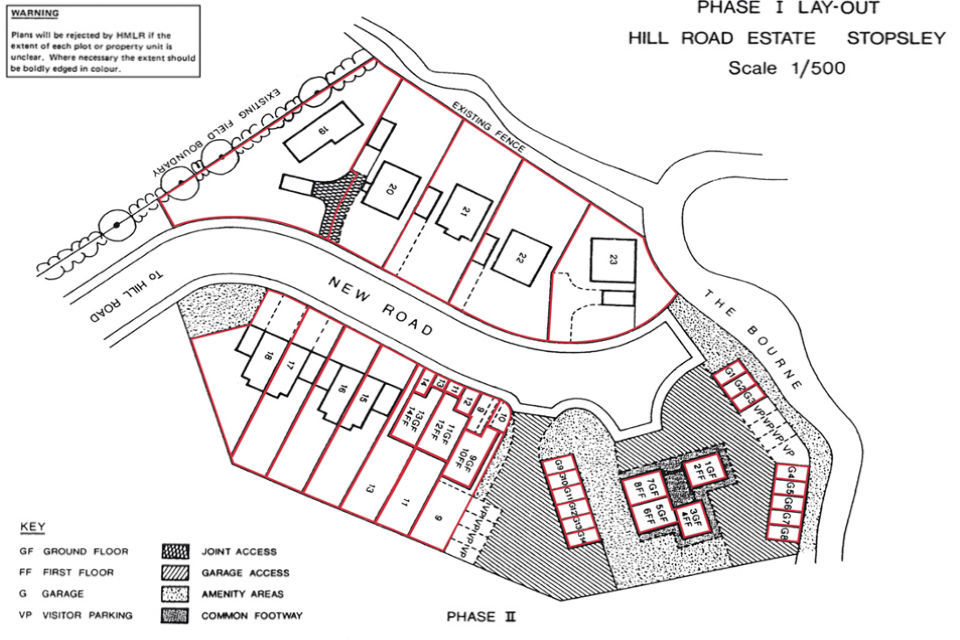
You can see examples of a typical title plan and estate layout plan below.
- The plan must clearly show the scale and orientation and be drawn to the scale quoted thereon. In addition to this, a bar scale could be added to the plan. The preferred scale is 1/500 although 1/1250 may be satisfactory if details of the layout including individual plot boundaries can be shown clearly. However, where the boundaries are intricate or complex, such as a boundary within a building, a larger scale may be necessary.
- Plans marked ‘For Identification only’ or ‘Do not scale from this drawing’ or any similar phrase are not acceptable.
- Plans, which bear a statement of disclaimer intended to comply with the Property Misdescriptions Act 1991, are similarly not acceptable.
- You must base the plan on an accurate survey, plotted to the chosen scale. The accuracy must be within the plottable limits of the scale ie distances scaled from the plan between well defined points of detail should be accurate to within 0.3mm at map scale plus one part in one thousand of the distance measured. For land surveyors, this specification gives the following tolerances:
| Distance scaled | 1/500 | 1/1250 |
|---|---|---|
| 100m | 0.15+0.1 = 0.25m | 0.375+0.1 = 0.475m |
| 200m | 0.15+0.2 = 0.35m | 0.375+0.2 = 0.575m |
| 500m | 0.15+0.5 = 0.65m | 0.375+0.5 = 0.875m |
| 1000m | 0.15+1.0 = 1.15m | 0.375+1.0 = 1.375m |
-
During the survey, you should site control stations in safe areas, thereby ensuring that the setting out of works and the final ‘as built’ survey are all based on the datum used for the original survey.
-
You must show any measurements in metric form.
-
You must show sufficient detail on the plan to enable us to relate the position of the proposed development to the boundaries of the land in the registered title or to other detail shown on the title plan. Therefore, you must ensure that detail immediately outside the external boundaries of the site is also shown on the plan.
-
The plan must clearly define the extent of each plot (including any separate parking spaces and garages) and show the number or reference identifying it. You must also precisely define the external boundaries of the plots so as to avoid any misinterpretation.
-
Where a property comprises more than one parcel (for example either a house plot with a separate garage or parking area or a flat with a separate garden) you must distinguish each parcel on the plan by means of a different number. If you give the same number to several parcels, difficulties of interpretation are likely to arise on an application for an official search of the register or inspection of the title plan. You can, however, describe the parts by separate references each of which could comprise the same plot number but a different letter prefix. The prefix may signify the purpose of each part, for example, where the house plot is numbered 46, the garage could be shown as G46 and the parking space as P46.
-
The plan must show buildings in their correct position on their plots and any access drives and pathways which form plot boundaries.
-
Any parts of the estate which are to remain as common parts, to be used as amenities or rights of way maintained by either the developer or the local authority, should be clearly indicated.
-
If two or more floors of a purpose built block of flats are co-extensive and the layout and extents of the flats are identical, it usually suffices if you supply a plan of the single floor. The plan must show the reference number distinguishing each flat and state the floor level of each flat.
-
Where boundaries are of an intricate or detailed nature, such as where they pass through a building, a larger scale plan or inset plan may be necessary.
If the plans lodged for approval do not meet the above requirements they will be rejected.

Practice guide 41s5 - image 1

Practice guide 41s5 - image 2
2.1 Plans printed from PDF and lodged for approval
HM Land Registry is increasingly rejecting plans lodged for approval because they are not to the stated scale. We suspect that plans are being accurately produced and sent as a PDF to solicitors. When they are printed from the PDF they are often inadvertently reduced to fit the paper size, and are therefore no longer to the stated scale.
Software settings can be adjusted to print the plan without a reduction in size.
When printing PDF files, ‘Page Scaling’ on the ‘Print’ menu can default to the ‘Shrink to Printable Area’ option (or a similar option, depending on your software). The ‘Preview’ panel will show the reduction in size expressed as a percentage.
To print without a size reduction, select ‘None’ in the ‘Page Scaling’ drop-down list. Depending on the size of the original image, the size of the paper may need to be changed.
To change the paper size, select the ‘Properties’ button, select the ‘Paper/Quality’ tab and then select the size of paper required from the appropriate ‘Paper Options’ drop-down menu.
After ‘Page Scaling’ has been changed it will subsequently default to ‘None’ on that PC for the user who changed it. If a different PC is used ‘Page Scaling’ will again need to be changed.
3. Reconciliation with Ordnance Survey maps
HM Land Registry bases its plans on large scale Ordnance Survey maps. In the case of developing estates these are normally drawn at 1/1250 scale. A developer can, therefore, be confident that, where there is conformity between the Ordnance Survey map and the developer’s estate layout plan, we will have little difficulty in relating the latter to our records.
In some circumstances (particularly where the Ordnance Survey map is at a scale 1/2500) a land surveyor may find differences between the site boundaries of the developer’s survey and the corresponding boundaries shown on the Ordnance Survey map. Any significant differences, that are identified when an accurately surveyed site plan is checked against the Ordnance Survey map, should be reported to the local Ordnance Survey Data Collection Field Office for investigation.
HM Land Registry revises its index map and the title plans of developer’s registered titles to show new buildings, fences, roads and other physical features. We do this at intervals, as the information becomes available from surveys carried out by Ordnance Survey.
Ordnance Survey has a responsibility to ensure that they properly survey the final development for the purpose of updating the Ordnance Survey map. However, if a satisfactory “as built” survey has been carried out for the developer by a competent land surveyor, Ordnance Survey may be able to make use of it to avoid the duplication of effort and expense. In this way the developer will ensure that the registration of the development proceeds without survey problems and, subject to negotiation with Ordnance Survey, may be able to recoup part of the cost of the ‘as built’ survey.
4. Things to remember
We only provide factual information and impartial advice about our procedures. Read more about the advice we give.

