River and floodplain management
Published 12 February 2025
Applies to England and Wales

© Crown copyright 2025
This publication is licensed under the terms of the Open Government Licence v3.0 except where otherwise stated. To view this licence, visit nationalarchives.gov.uk/doc/open-government-licence/version/3 or write to the Information Policy Team, The National Archives, Kew, London TW9 4DU, or email: psi@nationalarchives.gov.uk.
Where we have identified any third party copyright information you will need to obtain permission from the copyright holders concerned.
This publication is available at https://www.gov.uk/government/publications/natural-flood-management-evidence/river-and-floodplain-management
1. River restoration
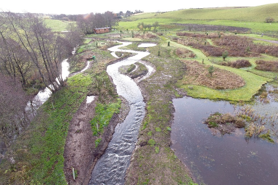
River Restoration at Cairn Beck. Image credit: Eden Rivers Trust (source - the NFM Hub, 2024)
River restoration is a reinstatement of the natural processes and features that are characteristic of a river.
Techniques can include:
- re-meandering
- removing man-made features
- reintroducing braided channels
In some cases, very little intervention is needed, while in others more extensive engineering and earthworks are required.
Flood risk from river restoration may be affected in several ways. This includes changing:
- channel roughness
- water storage times
1.1 What we know
We have medium confidence in the effect that river restoration has on flood risk.
We know that river restoration:
- can slow river flow and affect downstream peaks (by reintroducing features that reconnect the river with its floodplains, enable floodplain water storage, and increase inundation depth)
- can increase morphological diversity and change sediment sizes
- takes time to work (pace of adjustment will vary depending on flow and sediment supply)
- can reduce flood risk (but the extent depends on the length of river restored relative to the catchment size and may also be affected by other factors, including impoundment and floodplain connectivity)
- is most effective across entire reaches and in smaller catchments, but this may be due to challenges with monitoring at larger scales
- offers a range of techniques with different approaches suited to different river types
- will likely need maintenance that is site and design-specific, but it may change with time depending on the prevalence of flood events
1.2 Examples
In a 25 km2 catchment in the New Forest, a monitoring study found river restoration led to a 21% reduction in flood peak and a 33% increase in peak travel for a 2-year recurrence event (Sear and others, 2006).
Re-meandering within a Norfolk chalk stream resulted in a variation in channel depths, which increased the number of pools (Champkin and others, 2018).
A partially naturalised reach on the River Caldew, Carlisle, resulted in a net loss of material, whereas a large net gain was seen in the semi-braided reach. However, both naturalising reaches had larger relative active areas (40 to 41%) compared to the maintained control reaches (8 to 11%) (Heritage and Entwistle, 2020).
Modelling of river restoration in the Salmon Brook catchment has shown it can delay peak flow and reduce peak flood height at properties in the communities on the risk register (Gilbert, 2021a).
1.3 Multiple benefits
River restoration may result in improvements to:
- water quality
- habitat provision and biodiversity
- climate regulation
- health access
- flood risk reduction
While it is thought that river restoration may improve resilience to droughts, new evidence suggests that it can have minimal impact on water resources.

1.4 What we need to learn more about
We need to better understand:
- the flood risk reduction benefits, conveyance capacity and water storage effects that river restoration can provide
- long-term evaluation of flood risk reduction and multiple benefits
- catchment-wide factors that can boost ecosystem recovery
- the potential impact of different types of river restoration at greater spatial scales
- assessments to help improve design for future river restoration
1.5 References
CHAMPKIN, COPP, SAYER, CLILVERD, GEORGE, VILIZZI, GODARD, CLARKE, & WALKER, 2018. Responses of fishes and lampreys to the re-creation of meanders in a small English chalk stream. 34 (1). River Research and Applications. 34–43
GILBERT, 2021a. Salmons Brook Natural Flood Management Pilot: results and lessons. Thames21. [Accessed: 27 September 2023]
HERITAGE & ENTWISTLE, 2020. Impacts of River Engineering on River Channel Behaviour: Implications for Managing Downstream Flood Risk. 12 (5). Water. 1355
SEAR, D., KITTS, D. AND MILLIGAN, C., 2006. New Forest LIFE-III monitoring report: the geomorphic and hydrological response of New Forest streams to river restoration. Southampton: University of Southampton.
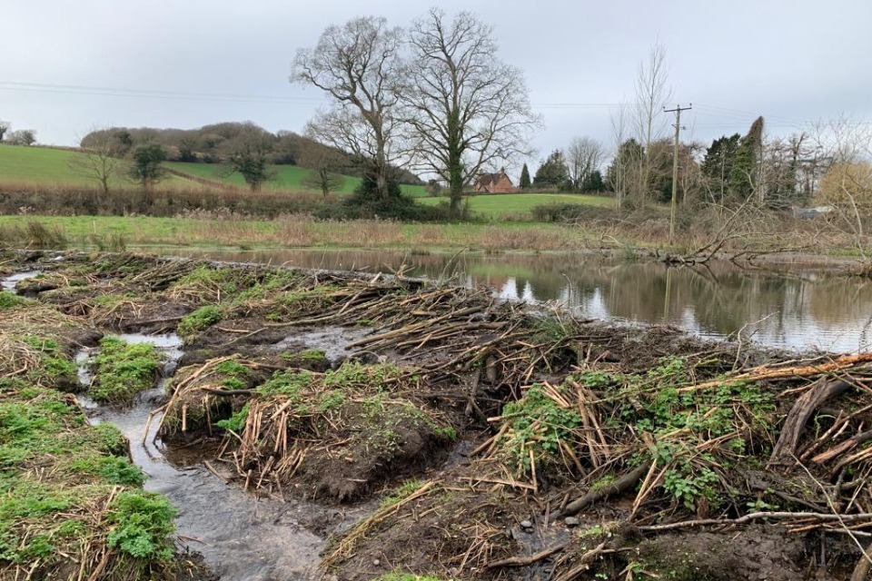
2. Floodplain and floodplain wetland restoration
Floodplain restoration, Holnicote Estate. Image credit: Matt Pang, National Trust
Wetlands are dynamic and changing habitats that include:
- fens
- grazing marsh and swamp
- upland and lowland peat bog
- reedbed
- wet woodland
- wet grassland
- wet heathland
Floodplains and floodplain wetlands can be restored or created to store large volumes of water for flood risk and ecological benefits.
Floodplain restoration aims to restore the hydrological connection between rivers and floodplains so that floodwater, sediment, and biological material inundate the floodplains and store water during times of high flows. This can involve removing flood embankments and other barriers to floodplain connectivity. Beaver activity can also significantly contribute to floodplain and floodplain wetland restoration.
2.1 What we know
We have low to medium confidence in the effect that floodplain and floodplain wetland restoration have on flood risk.
We know that floodplain and floodplain wetland restoration:
- can reduce or delay flood peaks (but these benefits are site-specific, hard to predict and can differ depending on location within the catchment)
- can reduce flood risk (but the extent of this effect depends on the length of river restored relative to catchment size, and also the river and floodplain type)
- take time before full floodplain connectivity is re-established and is able to attenuate larger flows
- can increase floodplain connectivity and overspilling (however this does not necessarily mean changes in the hydrograph will be observed)
- can capture and store sediment
- may attenuate high frequency, low return period floods
- may require some ongoing maintenance
In some circumstances, there could be a risk of increasing downstream flood risk, if peak flows become synchronised across the catchment.
2.2 Examples
Modelling of the River Dee found a large decrease in the required water level for overspilling after restoration. Peak water levels were higher on average post-restoration, although the difference varied depending on peak discharge (Addy and Wilkinson, 2021).
On the River Rom, modelling suggested channelling water through a purpose-constructed wetland would reduce peak flow downstream. For 1 in 20-year return period events, the modelling showed a 9% reduction in peak flow downstream of the constructed wetland and a 15% reduction in peak flow for a 1 in 100-year event (McKenna, 2021).
On the River Glaven, modelled and observed data showed that embankment removal led to floodplain inundation at high flows, with up to a 5% peak reduction in flood peak (Clilverd and others, 2013 and 2015).
2.3 Multiple benefits
Floodplain and floodplain wetland restoration may result in improvements to:
- water quality
- habitat provision
- climate regulation
- resilience to low flows
- flood risk reduction
Wetland restoration offers particularly high climate regulation and biodiversity benefits, but floodplain restoration also scores well for these categories. Water resources and air quality benefits can be more limited for both types of restoration.


2.4 What we need to learn more about
We need more work to better understand:
- flood risk benefit (or dis-benefits) across a range of return periods at downstream receptors resulting from restoration
- riparian processes at different temporal and spatial scales post-restoration
- scaling of projects from the local, wetland scale to larger, catchment scales
- the role of groundwater in floodplain restoration and different watercourse types
- how wetland hydrology functions across the variety of wetland types
- how assemblages of wetlands function together seasonally and annually
- maintenance requirements and whether floodplain restoration increases or decreases the need for in-channel maintenance downstream
- how to improve the design of solutions, including which features can be sited within the floodplain to further enhance flood risk benefit
2.5 References
ADDY & WILKINSON, 2021. Embankment lowering and natural self-recovery improves river-floodplain hydro-geomorphic connectivity of a gravel bed river. 770. Science of The Total Environment. 144626
CLILVERD, H.M., THOMPSON, J.R., HEPPELL, C.M., SAYER, C.D. and AXMACHER, J.C., 2013. River–floodplain hydrology of an embanked lowland Chalk river and initial response to embankment removal. Hydrological Sciences Journal-Journal Des Sciences Hydrologiques, 58 (3), 627-650.
CLILVERD, H., THOMPSON, J., HEPPELL, K., SAYER, C. AND AXMACHER, J., 2015. Removal of river embankments and the modelled effects on river–floodplain hydrodynamics. EGU General Assembly Conference Abstracts 2015, abstract 1297
MCKENNA, 2021. Rise Park Stream catchment, Hydraulic Modelling Report [Online]. Available from: https://jbagrp.sharepoint.com
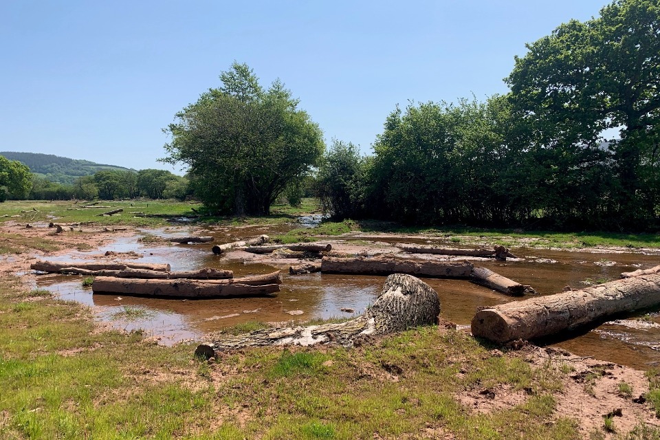
3. Leaky barriers
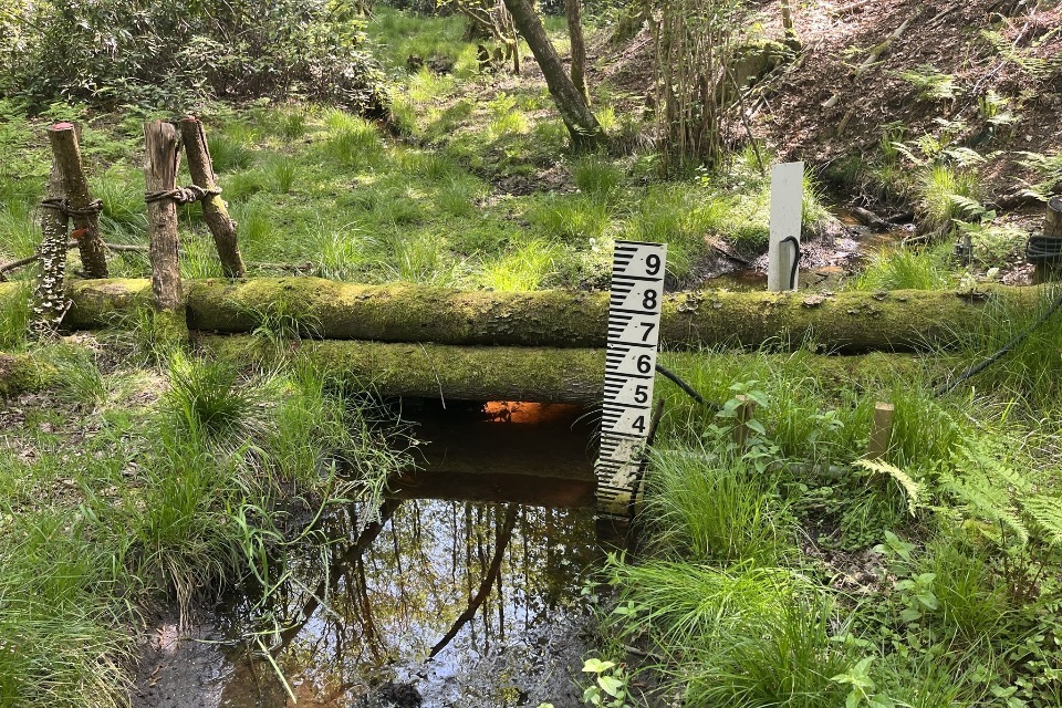
Leaky barriers, Dorking. Image credit: Ben Tonkin, Environment Agency
Leaky barriers are accumulations of wood, sometimes with living vegetation, in river channels, riverbanks or floodplains. They can also occur naturally along rivers because of trees falling.
They are also called:
- large woody debris
- log jams
- coarse woody debris
3.1 What we know
We have medium confidence in the effect that leaky barriers have on flood risk.
It is thought that leaky barriers:
- can reduce peak flow, but overall water volume stored is often modest
- will give flood risk benefits immediately once installed
- generally, show flood risk reduction benefits for small floods in small catchments (<10 km2) depending on design and placement
- can increase upstream water depth, with the corresponding backwater volume being proportional to the number, size, and packing density of the wood pieces in the barrier and extent of gaps, storing water and giving flood risk benefits
- may fail, but this is often site and technique-specific and could be a particular issue for fast flowing streams
- may require maintenance, particularly when there is no natural wood supply
- can alter ecology; this can often be positive but may be undesirable for species of conservation significance
- can work well when positioned in locations where they enable water to be shed from a channel into other storage features amid peak flow conditions
Caution is needed when installing leaky barriers to ensure they do not become detached and cause a downstream blockage with consequent effects on public safety. In some circumstances, there could be a risk of increasing downstream flood risk if peaks flows become synchronised across the catchment.
3.2 Examples
Five engineered leaky barriers installed on a flat, wide (26 m) decommissioned reservoir on the Smithills Estate, Bolton resulted in an average 27.3% reduction in peak water levels across a range of precipitation events of varying magnitude. Water was attenuated and backed up behind the barriers (Norbury and others, 2021).
Modelling of 50 leaky barriers and 11 tree trunk barriers in Edgware Brook and Silk Stream, Harrow, resulted in a 3% reduction in peak flow for the October 2020 event, dropping to 2% for a 20-year return period event and no effect on the 100-year event immediately downstream of the leaky barriers. No effect was noted in the community at risk, further downstream (Gilbert, 2021b).
3.3 Multiple benefits
Leaky barriers may result in improvement to:
- water quality (through sediment retention, although this may be limited)
- habitat provision (although this may present a barrier to fish passage)
- climate regulation
- resilience to low flows
- flood risk reduction
There are very limited benefits for amenity, air quality and soil identified from leaky barriers.

3.4 What we need to learn more about
We need to better understand:
- how reductions in flood peak flows caused by leaky barriers can translate into reductions in flood risk, and how leaky barriers may help reduce wider flood risks (for example, the benefits of debris dams working in conjunction with hard defences)
- the effectiveness of leaky barriers at greater flow magnitudes, at a range of catchment settings, geological environments and at larger spatial scales
- impacts in the long term on both flood risk and wider impacts as well as the life space of debris dams and whole life costs
- the influence of storm type, antecedent conditions and seasonality on performance of leaky barriers
- performance of a larger range of artificial and natural types of leaky barrier with different wood characteristics (such as wood density)
- how to improve leaky barrier representation within models, including at varying magnitudes
3.5 References
NORBURY, PHILLIPS, MACDONALD, BROWN, BOOTHROYD, WILSON, QUINN, & SHAW, 2021. Quantifying the hydrological implications of pre- and post-installation willowed engineered log jams in the Pennine Uplands, NW England. 603. Journal of Hydrology. 126855
GILBERT, 2021b. The River Pinn Park Wood NFM Pilot: results and lessons
4. Beavers
Beaver dam on the River Otter. Image credit: Elly Andison, Environment Agency
Eurasian beavers (Castor fiber) are often called ‘ecosystem engineers’ because they can modify habitats to meet their ecological needs.
Beavers create dams and canals that push water sideways, extending and creating complex wetland habitats. The dams and canals can slow and store water by increasing roughness, creating ponds and wetland features.
4.1 What we know
We have medium confidence in the effect that beavers have on flood risk.
It is thought that beaver dams and the complex habitats created:
- influence ecosystems profoundly, with significant associated positive hydrological, geomorphological, ecological and societal impacts
- can reduce longitudinal (downstream) connectivity, while simultaneously increasing lateral connectivity, pushing water sideways
- can increase surface water storage within ponds and canals, while also elevating the water table and contributing to groundwater recharge
- can attenuate flow in low and high flow periods, but may release flood water if dams become damaged
- can rapidly benefit locations where beaver dams create complex wetlands, often in headwaters and tributaries, and encompass benefits realised from leaky woody barriers, river and floodplain restoration, and offline storage areas
- may increase hydraulic roughness, reduce and slow flow velocities, trap fine sediment, create areas of sediment erosion and deposition, encourage sediment sorting and create in-channel features
- can slow flood flows as the dams encourage the river to reconnect with its floodplains, enable the storage of floodwaters on the floodplain and increase floodplain inundation depth
- can develop more benefits as features mature
- may increase groundwater storage but do not affect discharges
- can positively influence other wildlife and benefit wider issues such as drought and wildfire resilience
4.2 Examples
In the River Otter, the impacts of beaver colonisation were observed after 3 years. A delay to peak flow was observed, believed to be associated with an increase in storage capacity and a general slowing of the flow. In this example, the increase in storage was due to temporary floodplain storage which had also increased surface roughness. The study highlighted how topography influences how much beaver dams can slow the flow (Graham and others, 2022).
An analysis of storm events showed significant reductions in peak flows after beavers were re-introduced. The impact was greater at sites with well-established beaver activity. These impacts occurred over 4 sites, representative of the landscapes beavers are returning to in England (Puttock and others, 2021).
In the headwaters of the Tamar Catchment, Devon, total flows below the beaver-affected area were smaller than those above, with peak flows also showing a reduction. Significant differences were also noted during the largest storm events (Puttock and others, 2017).
4.3 Multiple benefits
The presence of beavers may result in improvements to:
- water quality (by storing sediment and associated nutrients)
- biodiversity (by creating new habitat)
- groundwater storage and, therefore, mitigate against drought and increase carbon storage and sequestration

4.4 What we need to learn more about
We need to better understand:
- examples from both real-world data and modelled scenarios to build further confidence in the evidence, particularly from the UK
- the hydrological impacts of beaver dams and sequences of beaver dams across scales and land uses
- the conditions of dam failure and consequences
- dam structure, number and location of dams in catchments required to have significant downstream flood reduction benefits
- confidence in the evidence, especially densely populated and intensively managed European landscapes
- influence of beaver landscape engineering on low flow conditions and wetland maintenance during drought
- whether beaver dam analogues/leaky woody debris dams could function as ‘starter dams’ to encourage beaver damming in optimal locations
- how to better represent beaver dams within models
4.5 References
GRAHAM, PUTTOCK, ELLIOTT, ANDERSON, & BRAZIER, 2022. Exploring the dynamics of flow attenuation at a beaver dam sequence. 36 (11). Hydrological Processes. e14735
PUTTOCK, GRAHAM, ASHE, LUSCOMBE, & BRAZIER, 2021. Beaver dams attenuate flow: A multi‐site study [Online]. 35 (2). Hydrological Processes. Available from: https://onlinelibrary.wiley.com/doi/10.1002. [Accessed: 28 April 2023]
PUTTOCK, GRAHAM, CUNLIFFE, ELLIOTT, & BRAZIER, 2017. Eurasian beaver activity increases water storage, attenuates flow and mitigates diffuse pollution from intensively-managed grasslands. 576. Science of The Total Environment. 430–443
5. Offline storage areas
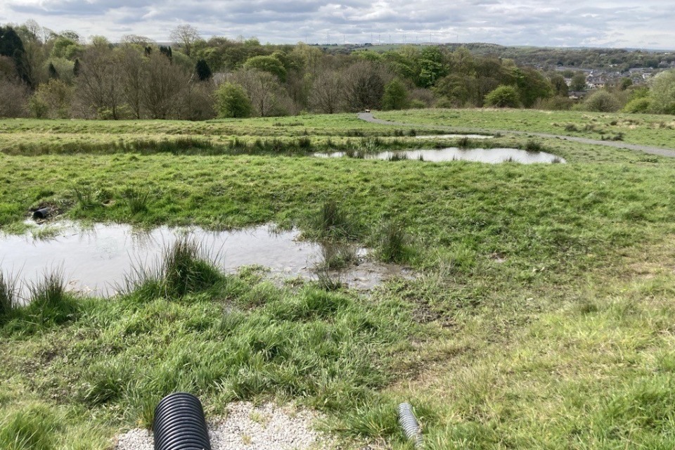
Offline storage area, Pleck Meadows. Image credit: Eleanor Heron, Environment Agency
Offline storage areas are floodplain areas that were adapted to retain and attenuate floodwater in a managed way.
They usually require the construction of a containment bund to increase the amount of water that can be stored on a floodplain. They may also have an inlet, outlet and spillway mechanism.
This summary focuses on small to medium scale offline storage areas (ponds) rather than engineered flood storage areas. The latter are typically online and built to reservoir safety standards.
5.1 What we know
We have medium confidence in the effect that offline storage areas have on flood risk.
It is thought that offline storage areas (ponds):
- work instantaneously
- can reduce flow velocities and create temporary storage which attenuates flood flows, but the rate of drainage affects the available storage and the ability to mitigate flood events that come in quick succession
- can reduce flood risk locally for small flood events
- can trap fine sediment during flood flows
- need to be bigger or more numerous as catchment size increases because a greater volume of storage is needed to reduce flood risk
- need to be designed carefully to allow for sufficient spilling and storage during the peak of flood events
- may require maintenance
Note that large storage areas or a series of smaller raised storage areas may have additional requirements if they fall under the Reservoirs Act.
5.2 Examples
An assessment of a two-pond network on the River Soar showed the ponds’ water levels to closely mirror the river water levels, leaving no available storage when it was needed during heavy rainfall events (Majeed, 2023).
Another example in Cumbria found ponds to drain almost to base level between flood peaks, indicating the ponds did not become overwhelmed and were able to slow flow throughout a flood event. These features can drain faster than online ponds as they stop receiving inflow once the stream levels decrease (Pearson, 2023a).
In a separate study of the same ponds, some issues with overflowing were noted during modest flood events. However, drainage through the overspill channel occurred quickly to create additional capacity during heavy rainfall periods (West Cumbria Rivers Trust, 2021b).
5.3 Multiple benefits
Offline storage areas have significant benefits for:
- flood risk reduction
- water resources
- biodiversity
- water quality (depending on how they are managed)
- amenity benefits (if they are designed for recreation)

5.4 What we need to learn more about
We need to better understand:
- the effectiveness of storage areas at reducing flood depths at a bigger scale for larger flood events
- the effects of using multiple storage areas throughout a catchment
- how to identify best locations for potential storage areas
- how storage areas may affect the potential for peak flows to align during a series of events
- how effective flood storage areas are in different types of watercourses
- how quickly storage will fill with sediments
- how storage areas function in different catchment types, such as groundwater-fed catchments
- maintenance requirements for offline storage areas
5.5 References
MAJEED, 2023. Soar NFM Project Data Analysis (2022-2023)
PEARSON, 2023a. Monitoring of Natural Flood Management water storage areas in the Glenderamackin catchment
WEST CUMBRIA RIVERS TRUST, 2023. Natural Flood Management Performance Monitoring Dovenby Bund