A guide to Forestry Commission’s sensitivity maps for woodland creation
Learn how our sensitivity maps can help you find out if your land is suitable for woodland creation and what environmental factors to consider.
Applies to England
You can view all the sensitivity maps on the Forestry Commission’s map browser, under ‘land sensitivity’.
Overview
We have developed a series of sensitivity maps, based on nationally available and consistent datasets to indicate where there are likely to be fewer sensitivities to woodland creation.
These will help landowners identify whether there is potential to establish new woodland on their land and where there may be sensitivities that would preclude planting or influence woodland design. If there are no obvious sensitivities, regulatory and grant processing is likely to be faster if complete applications are submitted.
The maps do not indicate that, where there is a low sensitivity to new woodland, planting will be agreed as appropriate by the Forestry Commission, responding to the views of Natural England, Environment Agency, Historic England, the local authority and other stakeholders. Likewise, planting/establishment of new woodland may be appropriate, particularly of native woodland, outside ‘low sensitivity’ areas.
England Woodland Creation Offer (EWCO) fast tracking
The low sensitivity map for woodland creation is used to define eligibility for EWCO’s fast-track process and associated low sensitivity land payment.
Eligibility for both the fast track and low sensitivity land payment will continue to be based on version 4.0 of the ‘low sensitivity’ for applications received before 1 January 2027.
Applications received after 1 January 2027 for both fast-tracking and the low sensitivity land payment will be based on version 5.0.
Find out more about EWCO fast tracking and the low sensitivity land payment.
Introduction to sensitivity maps for woodland creation version 5.0
This page provides the metadata for a series of related geospatial datasets that identify quantified assessments of the relative sensitivity of places for new woodland creation across all of England. Their purpose is to inform decisions on proposals for new planting of woodland.
The resultant geospatial datasets (map layers) have been created from an analysis of a range of other map layers and allocate all land in England according to its sensitivity to woodland creation into one of 4 categories:
- low sensitivity
- medium sensitivity
- high sensitivity
- unsuitable for woodland creation
The low sensitivity category has additionally been used to derive the ‘England woodland creation low sensitivity map’ geo-spatial data layer to help landowners and grant applicants engage with planting new woodlands.
At the time of publish (October 2026) the low sensitivity map for woodland creation version 5.0 described on this page is similar in name to but should not be confused with the ‘low risk map for woodland creation’ that remains in force as the formal map of reference for the Environmental Impact Assessment (EIA) regulations.
Relationship with the low-risk map for woodland creation
The low sensitivity map version 5.0 is a development of the low-risk map for woodland creation, as defined in the Environmental Impact (Forestry) Regulations (2017), with the main differences set as follows:
-
all areas of peat included in Natural England’s England peat map are excluded from the low sensitivity map (and its variants), with deep peat classified as ‘high sensitivity’ and shallow peat and other soils with peaty pockets classified as ‘medium sensitivity’
-
areas of land included in the wader zonal maps for curlew and golden plover as strata 2 to 5 are excluded from the low sensitivity map (and its variants), with strata 4 and 5 treated as high sensitivity and strata 2 and 3 as medium sensitivity
-
amended buffers are, in some cases, applied to Sites of Special Scientific Interest, Special protection Areas, Special Areas of Conservation and RAMSAR sites
-
integrated water bodies that are vulnerable to water resource constraints where existing woodland cover of the relevant type is more than 20% are treated as medium sensitivity and excluded from the low sensitivity map
-
land included in the enhanced Selected Heritage Inventory for Natural England geospatial layer is treated as medium sensitivity and excluded from the low sensitivity map
-
the low-risk map for woodland creation will continue to be used for meeting the requirements of the 2017 EIA (Forestry) regulations in terms of determining where notification may apply, rather than EIA screening; however, the full and low sensitivity maps represent a more current view of sensitivities to woodland creation
What’s changed between 4.0 and 5.0 of the sensitivity maps
Version 5.0 has been developed from version 4.0 of the sensitivity maps with the following changes:
- the Selected Heritage Inventory for Natural England (SHINE) geospatial layer has been added as an additional sensitivity – any of the 3 categories (low, medium and high) are categorised as medium sensitivity
- a geospatial layer identifying Integrated Water Bodies (IWBs) that are vulnerable to water resource constraints has been added as an additional sensitivity – IWBs where the relevant woodland cover (conifer or all woodland) exceeds 20% have been categorised as medium sensitivity
- the 2024 Land Classification Map has been incorporated as an update
- the 2024 National Forestry Inventory has been incorporated as an update
National breakdown of land sensitivity for woodland creation
Table 1. National breakdown of land sensitivity for the England woodland creation full sensitivity map version 5.0, the low sensitivity map (restricted to blocks more than 2 hectares in area) derived from it and the 3 variants.
| Sensitivity map | Variant | Sensitivity | Area of England (hectares) |
|---|---|---|---|
| Full sensitivity map v4.0 | None | Unsuitable | 3,327,426 |
| Low | 2,759,043 | ||
| Medium | 3,841,677 | ||
| High | 3,118,795 | ||
| Low sensitivity map v4.0 | Restricted to blocks less than 2 hectares in size | Low | 2,721,828 |
| Full sensitivity map v4.0, variant 1 | Agricultural Land Class (ALC) 3a: low sensitivity protected Landscapes: low sensitivity | Unsuitable | 3,327,426 |
| Low | 4,188,900 | ||
| Medium | 2,411,761 | ||
| High 3,118,795 | |||
| Full sensitivity map v4.0, variant 2 | ALC 3a: medium sensitivity protected landscapes: low sensitivity | Unsuitable | 3,327,426 |
| Low | 3,334,606 | ||
| Medium | 3,266,115 | ||
| High | 3,118,795 | ||
| Full sensitivity map v4.0, variant 3 | ALC 3a: low sensitivity protected Landscapes: medium sensitivity | Unsuitable | 3,327,426 |
| Low | 3,494,510 | ||
| Medium | 3,106,150 | ||
| High | 3,118,795 |
Potential area for woodland creation
Any land that falls under the following land classifications in the UK Centre for Ecology and Hydrology (UKCEH) Land Cover Map 2024 (25m raster):
| Type | Land classification identifier |
|---|---|
| Acid grassland | 7 |
| Arable and horticulture | 3 |
| Calcareous grassland | 6 |
| Heather | 9 |
| Heather grassland | 10 |
| Improved grassland | 4 |
| Neutral grassland | 5 |
The following non-woodland components of the National Forest Inventory are also included:
- agriculture land
- bare area
- grassland
- low density
- other vegetation
- shrub
Summary of the types of woodland creation sensitivity maps
The datasets now available are:
England woodland creation full sensitivity map v5.0
This dataset is the product of geospatial analysis to identify areas that may have sensitivities that need to be considered when creating new woodland in England. It identifies places regarded as either:
- Low sensitivity.
- Medium sensitivity.
- High sensitivity.
- Unsuitable (for woodland creation).
The full sensitivity map covers all of England to the high-water mark with the entire country assigned to one of the four categories set out above.
England woodland creation low sensitivity map v5.0
This dataset is based on a subset of the ‘England woodland creation full sensitivity map v5.0’ dataset, for England, showing only land regarded as:
1a. low sensitivity (as in the full sensitivity map), but with the additional criteria that these areas are greater than 2 hectares in extent.
Three variants of the low sensitivity map are also presented, further detail follows in the relevant sections:
1b. England woodland creation low sensitivity map v5.0 – variant 1
1c. England woodland creation low sensitivity map v5.0 – variant 2
1d. England woodland creation low sensitivity map v5.0 – variant 3
The low sensitivity map covers all of England to the high-water mark and shows where the land is assigned as low sensitivity according to the respective criteria for the specific map that follows.
What the sensitivity maps show
The England woodland creation full sensitivity map v5.0
Extent: England
Format: Raster grid. Polygon format is also available.
Grid resolution: 25 metres by 25 metres
Low sensitivity land for woodland creation
Land with a low sensitivity for woodland creation is defined in this map layer as land with any one or more of the following designations:
It is not:
- unsuitable
- high sensitivity for woodland creation
- medium sensitivity for woodland creation
It is also within land from the following land cover categories of the Land Cover Map (2024) published by UKCEH:
- acid grassland
- arable and horticulture
- calcareous grassland
- heather
- heather grassland
- improved grassland
- neutral grassland
The following non-woodland interpreted forest types from Forest Research’s National Forest Inventory woodland map (2024) are also included:
- agriculture land
- bare area
- grassland
- low density
- other vegetation
- shrub
Medium sensitivity land for woodland creation
Land with a medium sensitivity for new planting of woodland is defined in this map layer as land with any one or more of the following designations:
It is not:
- unsuitable
- high sensitivity for woodland creation
It is also in map layers defined as:
- Acid vulnerable catchments. Catchments are assessed for acid vulnerability using the water framework directive classification of water quality, published by the Environment Agency. We define acid vulnerability from the results for pH (one element of the physico-chemical quality test) and both fish and invertebrates which are elements of the biological quality test (i.e. all areas defined as ‘FAIL’, or ‘FAIL_BIO’ in the 2019 data).
- ALC. In areas ALC 1, or ALC 2 or ALC 3a as defined in the provisional agricultural land classification.
- National landscapes (previously Areas of Outstanding Natural Beauty).
- Birdlife International Important Bird Areas.
- Countryside Stewardship. a) Land parcels with Countryside Stewardship Scheme Agreements with end dates later than 31 December 2021 plus b) Land parcels in all Higher-tier agreements.
- Countryside Right of Way (CRoW) Act 2000 – S4 Conclusive Registered Common Land.
- Environmental Stewardship Higher Level agreements.
- Local nature reserves.
- National parks and the Broads.
- Natural England Peat Map (2008). On land with either shallow peaty soils = medium sensitivity and other soils with peaty pockets = medium sensitivity.
- Priority Habitat Inventory. In places that are any one or more of the following, fragmented heath, grass moorland, good quality semi-improved grassland.
- Wader Zonal Map for Golden Plover and Curlew breeding wading bird species (a combined layer showing highest sensitivity for either species). In either strata 2 or strata 3 areas (i.e. medium sensitivity).
- Ridge and furrow. Ridge and furrow with no buffer applied. Detection areas only.
- SHINE. Any of the three categories (low, medium and high).
- Integrated Water Bodies (conifer). Where conifer woodland cover exceeds 20%.
- Integrated Water Bodies (broadleaf). Where total woodland cover exceeds 20%.
High sensitivity land for woodland creation
Land with a high sensitivity for new planting of woodland is defined in this map layer as land within any one or more of the following designations:
It is not unsuitable.
It is also within:
- national nature reserves
- Natural England Peat Map. In areas of deep peaty soils
- Priority Habitat Inventory. Within other than fragmented heath, grass moorland and good quality semi-improved grassland
- RAMSAR sites. In, or within a 700m buffer
- registered battlefields. In, or within a 200m buffer
- registered parks and gardens. In or within a 200m buffer
- scheduled monuments. In or within a 200m buffer
- Special Protection Areas: in or within a 2,000m buffer
- Sites of Special Scientific Interest. If the land is above the moorland line, then in, or within a 1,000m buffer
- Sites of Special Scientific Interest. If the land is below the moorland line, then in, or within a 250m buffer
- Special Areas of Conservation. If the land is above the moorland line, then in, or within a 700m buffer
- Special Areas of Conservation. If the land is below the moorland line, then in, or within the 250m buffer
- Wader Zonal Map for Golden Plover and Curlew breeding wading bird species (a combined layer showing highest sensitivity for either species). In either strata 4 or strata 5 areas (i.e. high sensitivity)
- world heritage site. In, or within a 200m buffer
- wood pasture and parkland priority habitat. All categories
Land that is unsuitable for woodland creation
Land that is unsuitable for new planting of woodland is defined in this map layer as land with any one or more of the following designations based on Land Cover Map (2024) from the UKCEH with the following land classifications:
| Type | Land classification identifier |
|---|---|
| Bog | 11 |
| Coniferous woodland | 2 |
| Deciduous woodland | 1 |
| Fen | 8 |
| Freshwater | 14 |
| Inland rock | 12 |
| Littoral rock | 17 |
| Littoral sediment | 18 |
| Saltmarsh | 19 |
| Saltwater | 12 |
| Suburban | 21 |
| Supralittoral rock | 15 |
| Supralittoral sediment | 16 |
| Urban | 20 |
Or any of the following interpreted forest types from the National Forest Inventory woodland map (2024) from Forest Research:
- assumed woodland
- broadleaved
- conifer
- coppice
- coppice with standards
- failed
- felled
- ground prep
- mixed mainly broadleaved
- mixed mainly conifer
- open water
- quarry
- river
- road
- uncertain
- urban
- windblown
- young trees
All areas of England not thus defined as ‘unsuitable’ have gone on to be identified as either low sensitivity, medium sensitivity or high sensitivity.
The England woodland creation low sensitivity map v5.0
Extent: England
Format: Raster grid. Polygon format is also available.
Grid resolution: 25 metres by 25 metres
This is a separate geospatial map layer based upon a subset of the England woodland creation full sensitivity map v5.0.
It shows land parcels that fulfil both of the following criteria:
- Low sensitivity for woodland creation in the England woodland creation full sensitivity map v5.0.
- Of an extent of more than 2 hectares (i.e. > 2.0ha).
The England woodland creation low sensitivity map v5.0 – 3 further variants
Extent: England
Format: Raster grid. Polygon format also available.
Grid resolution: 25 metres by 25 metres
Of an extent of more than 2 hectares (> 2.0 ha)
These are 3 further, separate geospatial map layers based on the England woodland creation low sensitivity map v5.0:
England woodland creation low sensitivity map v5.0 – variant 1
This is the England woodland creation low sensitivity map v5.0 plus areas of land that have different sensitivities assigned compared to the core England woodland creation low sensitivity map v5.0:
- ALC 3a assigned as low sensitivity
- national landscapes (previously Areas of Outstanding Natural Beauty) assigned as low sensitivity
- national parks and the Broads assigned as low sensitivity
England woodland creation low sensitivity map v5.0 – variant 2
This is the England woodland creation low sensitivity map v5.0 plus areas of land that have different sensitivities assigned compared to the core England woodland creation low sensitivity map 5.0:
- national landscapes (previously Areas of Outstanding Natural Beauty) assigned as low sensitivity
- national parks and the Broads assigned as low sensitivity
England woodland creation low sensitivity map v5.0 – variant 3
This is the England woodland creation low sensitivity map v5.0 plus areas of land that have different sensitivities assigned compared to the core England woodland creation low sensitivity map 5.0:
- ALC 3a assigned as low sensitivity
Spatial datasets used in sensitivity mapping
| Dataset | Date of issue |
|---|---|
| Acid vulnerable catchments (see note 4) | 19 September 2023 |
| Agricultural Land Class (ALC) (see note 3) | 12 March 2019 |
| National landscapes (Areas of Outstanding Natural Beauty) | 18 June 2024 |
| Birdlife International Important Bird Areas (see note 5) | February 2020 |
| Countryside Stewardship | 17 June 2026 |
| CRoW Act 2000 – S4 Conclusive Registered Common Land | 24 October 2017 |
| Environmental Stewardship Higher Level Scheme agreements | 3 October 2022 |
| UKCEH Land Cover Map (2024) (see note 1) | 25 March 2026 |
| Local nature reserves | 18 June 2026 |
| National Forest Inventory woodland map (2024) | 3 September 2025 |
| National nature reserves | 29 June 2026 |
| National parks and the Broads | 10 December 2024 |
| Natural England Peat Map (see note 2) | 22 July 2021 |
| Priority Habitat Inventory | 23 October 2025 |
| RAMSAR sites | 23 January 2024 |
| Registered battlefields | 31 January 2025 |
| Registered parks and gardens | 29 June 2026 |
| Scheduled monuments | 29 June 2026 |
| Sites of Special Scientific Interest | 24 April 2025 |
| Special Areas of Conservation | 16 April 2024 |
| Special Protection Areas | 27 February 2025 |
| Wader Zonal Map | 17 February 2022 |
| World heritage sites | 29 June 2026 |
| Wood pasture and parkland priority habitat | 9 March 2026 |
| Ridge and furrow (see note 6) | 14 August 2023 |
| Integrated Water Bodies (see note 7) | 18 August 2025 |
| SHINE (see note 8) | 2 July 2026 |
Note 1: UKCEH Land Cover Map
UK Centre for Ecology and Hydrology’s Land Cover Maps are parcel-based thematic classifications of satellite image data covering the UK. They are used in a wide range of applications by government departments and agencies, county councils, charities and environmental management bodies.
Further details of the land cover map used for the woodland creation sensitivity maps can be found via the Digital Object Identifier; Morton, R,D; Marston C.G.; O’Neil.A.W.;Rowland.C.S; (2021). Land Cover Map 2024 (land parcels, GB) NERC EDS Environmental Information Data Centre.
Note 2: Natural England peat map 2008
Use Peaty soils location for more information on this data layer and licensing. By using this data you are accepting the terms of use of a third party supplier. You will be provided with the relevant terms of use. British Geological Survey (BGS), Cranfield University and Ordnance Survey must be acknowledged in any reports or documents produced as a result of using the peat layer.
Note 3: Provisional ALC
Data that has been further refined using the ‘Likelihood of Best and Most Versatile’ layer to split class 3 land into 3a and 3b. For this layer’s licence information email data.services@naturalengland.org.uk.
© Natural England copyright [2019], reproduced with the permission of Natural England © Crown copyright and database right [year]. Ordnance Survey licence number AC0000851168. Derived from 1:50 000 scale BGS Digital Data under licence 2006/072 British Geological Survey. © NERC. National Soils map © Cranfield University (NSRI) © Crown copyright and database rights [2026].
Note 4: The Acid Vulnerable Catchments layer
The mapping will be updated for each cycle of the river basin management plans. The ‘at risk’ category has been removed as there is enough evidence to determine if the catchment is vulnerable (failing) or not.
Waterbodies that have failed for pH (low pH – acidic) and/or biology due to acidification are treated as Failing and their catchments are flagged by failing in the column ‘RBMP_c3’.
Note 5: Important Bird Areas
Data reproduced with the permission of RSPB. © Crown copyright. Ordnance Survey licence number 100021787 (2022).
Note 6: Ridge and furrow
This dataset is subject to restrictions. It can only be used internally by the Forest Commission (Forest Services) and for inclusion in sensitivity and opportunity mapping where the data is aggregated with other large-scale datasets.
Note 7: The vulnerable IWB layer
This was developed by the Environment Agency as the most appropriate spatial scale to undertake water resource vulnerability modelling and guidance/regulation for the original research and development project. This dataset is subject to restrictions. It can only be used internally by the Forest Commission (Forest Services) and for inclusion in sensitivity and opportunity mapping where the data is aggregated with other large-scale datasets.
Note 8: SHINE
This dataset is subject to restrictions. SHINE data is owned and created by local historic environment services and provided under licence to Forest Services. It can only be used internally by the Forest Commission (Forest Services) and for inclusion in the land sensitivity mapping and the historic environment opportunity map for new woodland where the data is aggregated with other large-scale datasets.
Maps and variants of the full sensitivity map version 5.0
Map 1: England woodland creation full sensitivity map version 5.0.
Map 2: England woodland creation full sensitivity map version 5.0 variant 1.
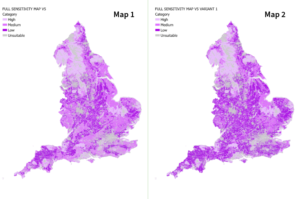
Map 1 and map 2: maps of England showing the different levels of sensitivity by shading. The darkest shading is 'low sensitivity' and the lightest is 'unsuitable'.
Map 3: England woodland creation full sensitivity map version 5.0 variant 2.
Map 4: England woodland creation full sensitivity map version 5.0 variant 3.
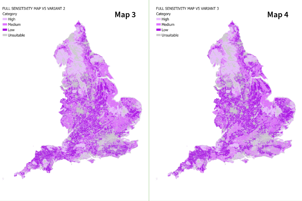
Map 3 and map 4: maps of England showing the different levels of sensitivity by shading. The darkest shading is 'low sensitivity' and the lightest is 'unsuitable'.
Map 5: England woodland creation low sensitivity map version 5.0.
Map 6: England woodland creation low sensitivity map version 5.0 variant 1.
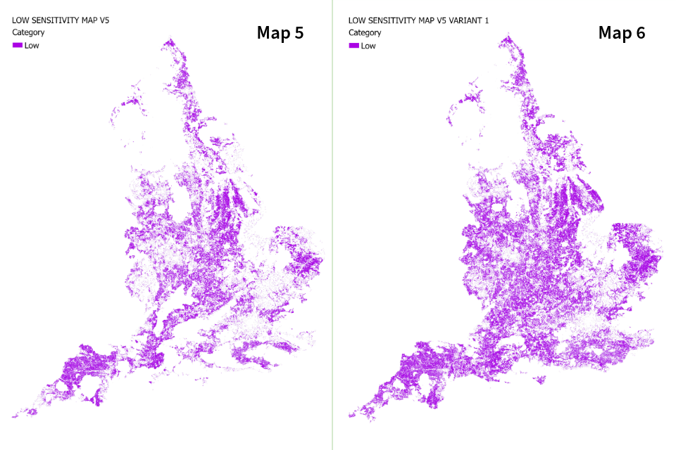
Map 5 and map 6: maps of England showing areas of low sensitivity by shading. Map 6 (variant 1) shows slightly more low sensitivity areas.
Map 7: England woodland creation low sensitivity map version 5.0 variant 2.
Map 8: England woodland creation low sensitivity map version 5.0 variant 3.
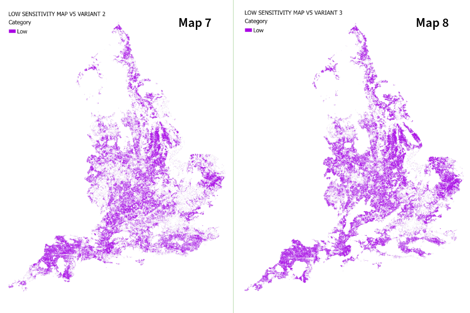
Map 7 and map 8: maps of England showing areas of low sensitivity by shading.
Contact us and further information
For further information on any of these woodland creation sensitivity map geospatial data layers you can contact:
evidence@forestrycommission.gov.uk
Previous sensitivity map versions
Version 4.0:
Version 3.0: