Grounding of bulk carrier Indian Partnership
Location: off the coast of Misool Island, Indonesian archipelago.
Completed preliminary assessment (PA) summary 4/24: Indian Partnership
Synopsis
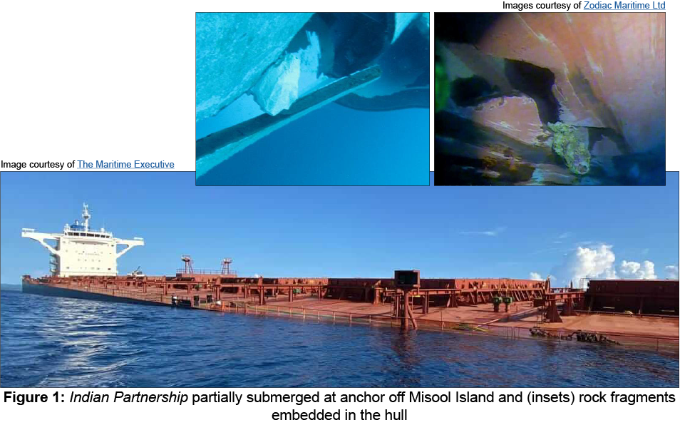
At 0409 on 23 April 2023, the UK registered bulk carrier Indian Partnership ran aground off the coast of Misool Island while transiting the Indonesian archipelago. The grounding caused significant breaches to the hull, leading to water ingress into the duct keel and five ballast water tanks (Figure 1).

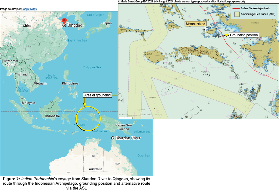
Indian Partnership had set sail from Skardon River, Australia on 19 April 2023, bound for Qingdao, China (Figure 2) with a cargo of bauxite and a maximum draught of 18.2m. Four days into the voyage, the vessel was nearing the east coast of Misool Island. At 0405, the vessel approached a 3-mile gap between two charted shoal areas and a few minutes later the vessel vibrated and dropped in speed. At this time the charted soundings indicated about 60m depth and the vessel’s echo sounder recorded an under keel clearance of just over 30m.

At 0411, bilge alarms activated and the vessel started to list to starboard (Figure 1). The master initiated a damage assessment and with water ingress confirmed the vessel was anchored in a sheltered offshore location. Following temporary repairs, Indian Partnership proceeded to a shipyard where the relevant repairs were made to the ballast tanks and duct keel.
The MAIB’s preliminary assessment identified that:
-
The vessel ran aground because it almost certainly struck an uncharted shoal.
-
The Electronic Chart Display and Information System (ECDIS) route for the previous voyage from China to Australia was developed offboard by a voyage optimisation and weather-routeing company. The southbound voyage had been completed without incident, in a ballast condition, with a maximum draught of about 8.9m.
-
• The northbound voyage plan created on board Indian Partnership was a reversal of the southbound track. Not all the relevant information available on the Electronic Navigational Chart (ENC) and associated ADMIRALTY[footnote 1] publications had been reviewed during the appraisal and planning stages for either voyage, resulting in a voyage plan with higher navigational risk and a route that passed close between two charted shoals.
-
The vessel did not follow the Indonesian Archipelagic Sea Lanes (ASL) (Figure 2), which were not mandatory but were International Maritime Organization (IMO) adopted transit corridors through the archipelago[footnote 2].
-
The ENC covering the area of the grounding was marked with a Category Zone of Confidence (CATZOC) of C, indicating that depth anomalies might be expected.
-
Indian Partnership’s safety management system documentation advised that mariners should exercise caution in CATZOC C areas.
-
The focus on minor waypoint adjustments using larger scale ENCs omitted the appraisal of smaller scale ENCs and reduced the possibility of identifying potentially more viable navigable routes. Such alternative routeing options could be missed on an ECDIS if the operator overscaled the ENC during planning. Additionally, zooming in beyond the original compilation scale during voyage monitoring could give the impression of greater accuracy than the source data provided and magnify positional errors.
Actions taken
The United Kingdom Hydrographic Office has issued a Notice to Mariners to insert a reported depth of 18.3m in the position of the grounding and forwarded the information to Pushidrosal, the Indonesian charting authority, to ensure the relevant charts are updated.
Zodiac Maritime Limited has:
- Completed an internal investigation into the grounding.
- Conducted an incident briefing with the vessel’s master.
- Distributed a briefing note to its staff about the voyage plan review process.
- Written to its fleet highlighting the lessons learned from the accident.
| Ship particulars | |
|---|---|
| Vessel’s name | Indian Partnership |
| Flag | UK |
| Classification society | Lloyd’s Register |
| IMO number | 9521409 |
| Type | Bulk carrier |
| Registered owner | Ronte Shipping Incorporated |
| Manager | Zodiac Maritime Limited |
| Operator | Oldendorff Carriers GmbH & Co. KG |
| Construction | Steel |
| Year of build | 2014 |
| Length overall | 292.0m |
| Registered length | 283.28m |
| Gross tonnage | 95,009 |
| Minimum safe manning | 15 |
| Authorised cargo | Dry cargo and grain |
| Voyage particulars | |
|---|---|
| Port of departure | Skardon River, Australia |
| Port of arrival | Qingdao, China |
| Type of voyage | International |
| Cargo information | 178,087t bauxite |
| Manning | 22 |
| Marine casualty information | |
|---|---|
| Date and time | 23 April 2023 at 0409 |
| Type of marine casualty or incident | Serious Marine Casualty |
| Location of incident | Near Misool Island, Indonesia |
| Place on board | Hull |
| Injuries/fatalities | None |
| Damage/environmental impact | Significant breaches of hull, leading to water ingress into five ballast tanks requiring dry dock repair |
| Ship operation | In passage |
| Voyage segment | Coastal |
| External and internal environment | Clear sky with a moderate breeze; slight seas; good visibility, air temperature 29°C |
| Persons on board | 22 |
-
A portfolio of electronic and paper nautical charts, publications, and digital services produced by the UK Hydrographic Office (UKHO), including comprehensive coverage of the world’s commercial shipping routes and ports https://www.admiralty.co.uk/ ↩
-
IMO Circular, SN/Circ.206, Guidance for Ships Transiting Archipelagic Waters. ↩