UKHSA and BGS publish updated radon map for Great Britain
The UK Health Security Agency (UKHSA) and the British Geological Survey (BGS) have published an updated radon potential map for Great Britain.
The risk of developing lung cancer from exposure to radon remains low and the vast majority of buildings remain outside Affected Areas.
Individuals and employers are encouraged to check the map to see if a radon test is advised in homes and workplaces in their area.
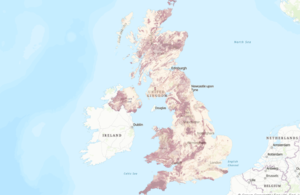
The updated radon potential map, produced by UKHSA and BGS, is the first in over 10 years and provides an authoritative analysis of the likelihood of a building being in a radon Affected Area (an area with higher radon potential).
Radon is a colourless and odourless gas that is attributed to 1,100 lung cancer deaths per year in the United Kingdom. The risk is highest among smokers and ex-smokers.
For most people, the risk of developing lung cancer from exposure to radon remains low and levels of radon have not increased across the UK. However, UKHSA advises you to test your home if you live or work in an Affected Area. There are several methods of reducing high radon levels in buildings.
The latest update to the map, available to view at UKradon.org, is the product of years of new analysis and research, combining the latest geological mapping with one of the largest databases of in-home measurements ever compiled.
While the vast majority of buildings remain outside radon Affected Areas, this new map has refined our knowledge of areas where high radon levels are more likely to occur. The overall number of buildings with high radon levels remains the same.
The radon map allows local councils, national and regional governments, social and private landlords, private homeowners and employers to assess the radon risk in their properties. It is also used in building regulations to inform where radon preventative measures should be incorporated in new buildings.
Tracy Gooding, principal radiation protection scientist at UKHSA, said:
While the vast majority of buildings remain outside radon Affected Areas, if the property you own is in a radon Affected Area, it is important that you arrange for a test. If you live in private or social rented accommodation, speak to your landlord, who should organise a test for you to carry out.
Employers can use this map to help undertake a suitable and sufficient risk assessment and take appropriate action where necessary.
The updated map provides information that allows property owners, landlords and employers to make informed decisions on the benefits of undertaking radon measurements and potential remediation work.
Russell Lawley, principal geologist at BGS, said:
Radon occurs in all rocks and soils. Using a revised statistical approach to our mapping of geology across Great Britain has enabled us to model where this geo-hazard is more likely to be present in buildings.
This map is a significant update to the previously published version and will help to raise awareness about this geohazard.
Guidance for radon Affected Areas can be found at UKradon.org.
Further information on techniques available to lower elevated levels of radon is also available.
The map has been updated in England, Wales and Scotland. The map for Northern Ireland, which was last updated in 2015, remains the same as before.
UK Health Security Agency press office
10 South Colonnade
London
E14 4PU
Updates to this page
-
Corrected to clarify that the number of lung cancer deaths per year is for the UK rather than Great Britain.
-
First published.